A walk along the White Cliffs As English icons go, they don't come much bigger than theWhiteCliffsofDover. Up to 100 metres tall in places, towering above the Channel and visible for miles. We take chalk cliffs for granted on the southern and eastern coasts of England, but globally they're actually surprisingly rare. The only other chalk cliffs outside the UK are to be found across the Channel in Normandy and near Calais, and on the two Baltic islands of Mon and Rügen. The very best place to see the white cliffs of Dover is from a passing boat. However, in the absence of marine transport, I decided instead to view them from above and set off on a two mile trek east along the clifftops. To the lighthouse.
It was quite some climb up to the summit of the cliffs from harbour level, or at least it was on foot. Lazier or less able visitors were able to drive direct to a clifftop carpark sponsored by Saga Holidays, which perhaps suggested that walking conditions weren't going to be especially strenuous. It certainly looked easy to walk from the car park to the visitor centre, or to amble along the nearby flat footpaths, but further east the ground looked rather more undulating. Indeed, just beyond the coastguard station anybody in stilettos would be in real trouble and sensible walking shoes were de rigeur. Nevertheless the initial view was excellent, both along the coastline and out to sea across the docks. Several people were stood with binoculars poised, scrutinising the passing shipping (of which there was plenty). Dog walkers were also out in force, although to my great surprise I never quite saw any yappy mongrels scampering over the cliff edge to their death.
In this Health and Safety conscious age, it was refreshing to see that nobody has yet erected luminous orange safety barriers along the edge of the cliffs. You can walk right up to the brink and look down at the sheer chalk beneath, if you so wish. Visitors are, however, recommended to keep at least five metres from the cliff edge just in case the rock decides that, after 70 million years in situ, today is the day to crumble spectacularly into the sea below. On average the shoreline retreats approximately 50cm each year, but in reality rockfalls tend to be rarer and more spectacular than this average might suggest. I was brave enough to venture up close anyway, and the fact that I'm still here today to post the photographs I took suggests that my risk analysis was well judged. Bloody fantastic views they were too.
The further I got from the car park, the smaller the crowds of fellow ramblers became. The footpath curved and climbed before descending again across another sinking valley. At one point narrow steps dropped almost vertically down the chalkface to Langdon Bay beneath, where one matchstick sized couple seemed to be enjoying the remote solitude of the wafer-thin pebbly beach. Back up top a handful of windswept trees thrust their stunted branches defiantly offshore, while grassy shoots pushed bravely up above the chalky soil to semi-cover a fallow field. And all the time, out on the horizon across the sea, there was France. Or maybe it was just a deep grey cloudbank, it was hard to be sure. I suspect the walk is rather more hospitable in midsummer, but even on a cold sunny day the experience was quite magical. And then there was the lighthouse...
SouthForelandLighthouse Just off the east coast of Kent, just below the waters of the English Channel, lie the treacherous Goodwin Sands. Hundreds of ships have foundered here over the centuries, so the nearby coast was a natural location for a lighthouse as early as 1499. The present South Foreland Lighthouse dates back to 1691, extended to its current height in 1890, and boasts several world-beating firsts: • the first lighthouse to be lit byelectriclight[Michael Faraday, 1858] • the first ship-to-shore radio transmission (from the South Goodwin lightship) [Marconi, Xmas Eve 1898] • the first ship-to-shore radio distress call (from the South Goodwin lightship) [Marconi, April 1899] • the first international radio transmission (to Wimeraux, France) [Marconi, March 1899] • the last UK lighthouse to be fully automated [Trinity House, 1998]
Today the South Foreland Lighthouse is owned by the National Trust, whose volunteers seemed very pleased to see me on Saturday and to show me around. I guess that, being in such a remote clifftop location some distance from the nearest public car park, they were glad of every visitor they could get. My guide was extremely knowledgeable (or else had been busy learning all the relevant facts over the winter break). He explained in detail how the lighthouse had been powered, enthused over an original 3KW light bulb and also demonstrated the intricate mechanism used to rotate the optic in the lantern room (recently restored). From the roof I could see down into the nearby village of St Margaret's (where Noel Coward and Ian Fleming once lived), but I decided that was too far to venture on today's journey. Having reached the very south-easternmost tip of the British mainland, I retraced my steps back along the clifftops to Dover. Absolutely knackering, but absolutely worth it.
70 miles southeast of London lies one of the most famous towns in England - Dover. The town's worldwide fame as the gateway to Britain rests on two geographical quirks. First there are the cliffs - tall, majestic and white - with just one accessible breach where the river Dour has cut a valley deep down through the chalk. And second there's France, just 21 miles away across the English Channel, making this the closest spot in the UK to continental Europe. And so the town of Dover grew up here on the Kent coast, between the white cliffs and opposite Calais. Over the years its unique frontline location has attracted the attention of Julius Caesar, William the Conqueror, Henry VIII, Guglielmo Marconi, Louis Bleriot, Adolf Hitler and numerous asylum seekers. Yesterday I joined their esteemed company by taking the train down to Dover to see the place for myself.
Dover's one of those places you usually pause and pass through, not somewhere you tend to stop. I'd been a few times before - down the big curvy ramp and onto the ferry - but only on school trips abroad and without disembarking from the coach. But there's actually plenty to do and see in and around the town itself, far more than I could manage in a day. The town's museum boasts a bronze age boat (the world's oldest seagoing boat, no less), dug up a few years ago when builders were scything a dual carriageway along the seafront. There's also the remains of a Roman'hotel' with extensive painted walls, apparently the best preserved Roman town house in the country (but closed until April). Most of the town centre is pretty standard, though. Gangs of chattering teens gather up side alleys and mass in the local park (I agree, Laura-Ann, Dover's far chavvier than I was expecting). Pensioners buzz between the minor chain stores on their mobility scooters (I have no idea why anybody would want to retire here - all the interesting places are up steep slopes). Property is cheap, and everything I saw hinted that unemployment is high. For many local residents Dover appears to be somewhere they're trapped, not somewhere they have a future.
DoverCastle It's been obvious to every military leader since the Iron Age where precisely on the southeast coast of Britain they should build their main fortress. Here, in Dover, above the harbour, beside the town, atop the sheer white cliff, bang opposite France. Both Julius Caesar and William the Conqueror diverted their invading armies a few miles up the coast from Dover, to where the defences were weaker, then marched in overland and established their own military presence here. The oldest building on site is the Roman-built lighthouse (or pharos), dating back to the first century AD. The bottom half still stands (pictured), tucked up beside the rear of the half-as-old Saxon church, although the dark interior of this decaying stone tower is now just somewhere for local pigeons and seagulls to roost. Henry II enlarged Williams motte and bailey by erecting a tall stone keep - still the castle's dominant centrepiece. It's a wonderful building to explore, full of spiral staircases, long passages and side chambers, plus there's a great view across Dover from the four turrets on the roof. Elsewhere you can descend deep into the castle's medieval tunnels - long snaking defensive pathways which twist on (and on) into the dark underbelly of the clifftop, just like you might expect to find beneath Hogwarts. There's also a much more up-to-date labyrinth of secret WW2 tunnels dug into the cliff, complete with underground hospital and command centre in which the Dunkirk landings were planned. It's an extensive site, so allow yourself more than 55 minutes for your visit - my late-entry ticket may have cost half price, but I don't think I did the place justice.
The port ofDover Dover is one of the original medieval CinquePorts (pronounced, rather worryingly, 'sink'). Whereas most of the other harbours have long since become unnavigable (or, indeed, landlocked), the port of Dover continues to thrive. The docks dominate the shoreline of the town, from the hoverport, cargo depots and marina to the west to the vast ferry terminals out east. During the railwayage trains ran right down to the docks, but declining rail traffic means that DoverMarine station is now long gone, replaced by a Cruise Liner terminal. Now almost everything and everyone arrives by road, so the Eastern Docks are by far the most important. The A2 trunk road cuts through the chalk and descends into the docks on concrete stilts, delivering articulated lorries, cars and coaches direct into the heart of the docks. It's only from a vantage point on the cliffs above that the full scale of operations is revealed. I looked down across acres and acres of flat land reclaimed from the sea, covered by tarmac, covered by parking spaces and brightly coloured containers. Lorry drivers and holidaymakers were being nudged and funnelled around the site, swirling through a series of booths and customs checks before parking up on the harbourside beside a 'food village' to await boarding. Giant roll-on roll-off ferries lined up to accept each new batch of escapees, before closing their bowdoors and chugging off through the gap in the breakwater and out into the Channel. It was hypnotic to watch and a reminder that, even in these days of air travel and Eurostar, Britain remains an island nation dependent on its links with the sea.
Harry Beck's London Underground map is such a design icon that computerfolk are forever designing spoof versions. There's the marvellous upside-down South London version, for example, and the ingenious London motorways map. But the usual trick is to retain the real diagram and just change the names of all 275 stations instead. Simon Patterson was probably the first (in 1992) with his Great Bear, but since then the tube map has also gone foody, German, sweary (not worksafe), Hollywood and (just last week) ingeniously musical. You can find tons more tube map variants over at Geoff's place and Owen's site.
And now to add to the collection (viavia) there's a brand new London Underground map where each station name is replaced by an anagram. Simple, but brilliant. See it here.
Not all London station names are especially angrammable (Bow Road, for example, becomes the none-too inspiring 'Woo Bard'). Some, however, are cunningly simple (like the new termini at 'Pigpen', 'Modern', 'Ragweed' and 'A Monster'). But the great majority of the new names are just amusingly stupid (like 'Crux For Disco' for Oxford Circus, and 'Frog Innard' for Farringdon). By way of illustration, I've listed below the revised names for all the stations along Silverlink's North London Line, from west to east. But if you take a good look at the map yourself, you'll probably have your own favourites...
North London Line: Inch Dorm, Greek Dawns, Sunny Burger, Count Oaths, Natal Concert, Swelled Injunction, Lake Sirens, Do Raspberry Bunk, Rubber Synod, What Stampedes, Dragonfly & Falcon Hire, Hate Shamed Path, A Log Spoke, Wok Stew Thinnest, Add Romance, Absorbancy & Neural Android, This Hungry & Boiling, Cyan Bourn, Dark Tonsil Glands, Centenary Chalk, No Mother, Why Kick Acne, Draft Rots, Wet Mash, Want Conning, Scouse Mouth, Striven Owl, Choir Howl Town.

In this Health and Safety conscious age, it was refreshing to see that nobody has yet erected luminous orange safety barriers along the edge of the cliffs. You can walk right up to the brink and look down at the sheer chalk beneath, if you so wish. Visitors are, however, recommended to keep at least five metres from the cliff edge just in case the rock decides that, after 70 million years in situ, today is the day to crumble spectacularly into the sea below. On average the shoreline retreats approximately 50cm each year, but in reality rockfalls tend to be rarer and more spectacular than this average might suggest. I was brave enough to venture up close anyway, and the fact that I'm still here today to post the photographs I took suggests that my risk analysis was well judged. Bloody fantastic views they were too.
Just off the east coast of Kent, just below the waters of the English Channel, lie the treacherous Goodwin Sands. Hundreds of ships have foundered here over the centuries, so the nearby coast was a natural location for a lighthouse as early as 1499. The present South Foreland Lighthouse dates back to 1691, extended to its current height in 1890, and boasts several world-beating firsts:
70 miles southeast of London lies one of the most famous towns in England - Dover. The town's worldwide fame as the gateway to Britain rests on two geographical quirks. First there are the cliffs - tall, majestic and white - with just one accessible breach where the river Dour has cut a valley deep down through the chalk. And second there's France, just 21 miles away across the English Channel, making this the closest spot in the UK to continental Europe. And so the town of Dover grew up here on the Kent coast, between the white cliffs and opposite Calais. Over the years its unique frontline location has attracted the attention of Julius Caesar, William the Conqueror, Henry VIII, Guglielmo Marconi, Louis Bleriot, Adolf Hitler and numerous asylum seekers. Yesterday I joined their esteemed company by taking the train down to Dover to see the place for myself.
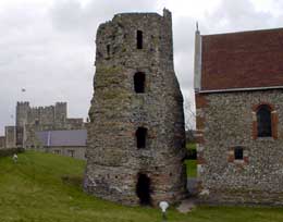
It's been obvious to every military leader since the Iron Age where precisely on the southeast coast of Britain they should build their main fortress. Here, in Dover, above the harbour, beside the town, atop the sheer white cliff, bang opposite France. Both Julius Caesar and William the Conqueror diverted their invading armies a few miles up the coast from Dover, to where the defences were weaker, then marched in overland and established their own military presence here. The oldest building on site is the Roman-built lighthouse (or pharos), dating back to the first century AD. The bottom half still stands (pictured), tucked up beside the rear of the half-as-old Saxon church, although the dark interior of this decaying stone tower is now just somewhere for local pigeons and seagulls to roost. Henry II enlarged Williams motte and bailey by erecting a tall stone keep - still the castle's dominant centrepiece. It's a wonderful building to explore, full of spiral staircases, long passages and side chambers, plus there's a great view across Dover from the four turrets on the roof. Elsewhere you can descend deep into the castle's medieval tunnels - long snaking defensive pathways which twist on (and on) into the dark underbelly of the clifftop, just like you might expect to find beneath Hogwarts. There's also a much more up-to-date labyrinth of secret WW2 tunnels dug into the cliff, complete with underground hospital and command centre in which the Dunkirk landings were planned. It's an extensive site, so allow yourself more than 55 minutes for your visit - my late-entry ticket may have cost half price, but I don't think I did the place justice.
Dover is one of the original medieval Cinque Ports (pronounced, rather worryingly, 'sink'). Whereas most of the other harbours have long since become unnavigable (or, indeed, landlocked), the port of Dover continues to thrive. The docks dominate the shoreline of the town, from the hoverport, cargo depots and marina to the west to the vast ferry terminals out east. During the railway age trains ran right down to the docks, but declining rail traffic means that Dover Marine station is now long gone, replaced by a Cruise Liner terminal. Now almost everything and everyone arrives by road, so the Eastern Docks are by far the most important. The A2 trunk road cuts through the chalk and descends into the docks on concrete stilts, delivering articulated lorries, cars and coaches direct into the heart of the docks. It's only from a vantage point on the cliffs above that the full scale of operations is revealed. I looked down across acres and acres of flat land reclaimed from the sea, covered by tarmac, covered by parking spaces and brightly coloured containers. Lorry drivers and holidaymakers were being nudged and funnelled around the site, swirling through a series of booths and customs checks before parking up on the harbourside beside a 'food village' to await boarding. Giant roll-on roll-off ferries lined up to accept each new batch of escapees, before closing their bow doors and chugging off through the gap in the breakwater and out into the Channel. It was hypnotic to watch and a reminder that, even in these days of air travel and Eurostar, Britain remains an island nation dependent on its links with the sea.
Odd loon dung runner spam
Oh boy...


 In this Health and Safety conscious age, it was refreshing to see that nobody has yet erected luminous orange safety barriers along the edge of the cliffs. You can walk right up to the brink and look down at the sheer chalk beneath, if you so wish. Visitors are, however, recommended to keep at least five metres from the cliff edge just in case the rock decides that, after 70 million years in situ, today is the day to crumble spectacularly into the sea below. On average the shoreline retreats approximately 50cm each year, but in reality rockfalls tend to be rarer and more spectacular than this average might suggest. I was brave enough to venture up close anyway, and the fact that I'm still here today to post the photographs I took suggests that my risk analysis was well judged. Bloody fantastic views they were too.
 Just off the east coast of Kent, just below the waters of the English Channel, lie the treacherous
  70 miles southeast of London lies one of the most famous towns in England -
  It's been obvious to every military leader since the Iron Age where precisely on the southeast coast of Britain they should build their main fortress. Here, in Dover, above the harbour, beside the town, atop the sheer white cliff, bang opposite France. Both Julius Caesar and William the Conqueror diverted their invading armies a few miles up the coast from Dover, to where the defences were weaker, then marched in overland and established their own military presence here. The oldest building on site is the Roman-built lighthouse (or
  Dover is one of the original medieval
  Oh boy...