Tuesday, September 17, 2019
One thing Flickr allows me to do is look on a map to see where all my photographs are located. It doesn't allow you to do this, that facility was withdrawn years ago, but I'm allowed a map so that I can drop every fresh photo onto its correct geographical location. I added my first photos to Flickr way back in 2005, and have now uploaded over 15000 in total. They're mostly in and around London and the south east, but also widely spread elsewhere.
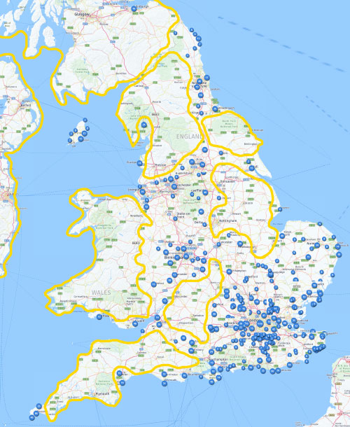
So I decided to stitch together several snapshots to create a giant map of the UK to show where my photos have been taken. I hoped this might be a good way to view my travels across the country and to see where I've been... and, more particularly, where I haven't.
The blue blobs show where I've taken photos, maybe one, maybe several. The blue blob in the centre of London simply says 'lots'. Meanwhile the yellow-bordered zones show large tracts of Britain where I haven't been... or haven't blogged... or at least haven't uploaded any photos.
The island of Ireland is a blank.
So is Scotland, other than Edinburgh and a cluster on the Outer Hebrides (not shown).
So is Wales, other than Swansea and Cardiff.
Rest assured I have travelled more widely than that, but before 2005 so it doesn't show up.
As for England, I have five significant unphotographed zones:
1) Lancashire, the Pennines and the Lake District (other than Blackpool and Lake Windermere).
2) North Yorkshire
3) Nottinghamshire, Lincolnshire and the Fens (other than Retford and Skegness)
4) The south Midlands (a swathe from Rugby to Swindon via Cheltenham)
5) The Southwest (other than Penzance, Exeter and south Dorset)
I have taken note of these results, and am considering future plans.
...or read more in my monthly archives
Jan26 Feb26
Jan25 Feb25 Mar25 Apr25 May25 Jun25 Jul25 Aug25 Sep25 Oct25 Nov25 Dec25
Jan24 Feb24 Mar24 Apr24 May24 Jun24 Jul24 Aug24 Sep24 Oct24 Nov24 Dec24
Jan23 Feb23 Mar23 Apr23 May23 Jun23 Jul23 Aug23 Sep23 Oct23 Nov23 Dec23
Jan22 Feb22 Mar22 Apr22 May22 Jun22 Jul22 Aug22 Sep22 Oct22 Nov22 Dec22
Jan21 Feb21 Mar21 Apr21 May21 Jun21 Jul21 Aug21 Sep21 Oct21 Nov21 Dec21
Jan20 Feb20 Mar20 Apr20 May20 Jun20 Jul20 Aug20 Sep20 Oct20 Nov20 Dec20
Jan19 Feb19 Mar19 Apr19 May19 Jun19 Jul19 Aug19 Sep19 Oct19 Nov19 Dec19
Jan18 Feb18 Mar18 Apr18 May18 Jun18 Jul18 Aug18 Sep18 Oct18 Nov18 Dec18
Jan17 Feb17 Mar17 Apr17 May17 Jun17 Jul17 Aug17 Sep17 Oct17 Nov17 Dec17
Jan16 Feb16 Mar16 Apr16 May16 Jun16 Jul16 Aug16 Sep16 Oct16 Nov16 Dec16
Jan15 Feb15 Mar15 Apr15 May15 Jun15 Jul15 Aug15 Sep15 Oct15 Nov15 Dec15
Jan14 Feb14 Mar14 Apr14 May14 Jun14 Jul14 Aug14 Sep14 Oct14 Nov14 Dec14
Jan13 Feb13 Mar13 Apr13 May13 Jun13 Jul13 Aug13 Sep13 Oct13 Nov13 Dec13
Jan12 Feb12 Mar12 Apr12 May12 Jun12 Jul12 Aug12 Sep12 Oct12 Nov12 Dec12
Jan11 Feb11 Mar11 Apr11 May11 Jun11 Jul11 Aug11 Sep11 Oct11 Nov11 Dec11
Jan10 Feb10 Mar10 Apr10 May10 Jun10 Jul10 Aug10 Sep10 Oct10 Nov10 Dec10
Jan09 Feb09 Mar09 Apr09 May09 Jun09 Jul09 Aug09 Sep09 Oct09 Nov09 Dec09
Jan08 Feb08 Mar08 Apr08 May08 Jun08 Jul08 Aug08 Sep08 Oct08 Nov08 Dec08
Jan07 Feb07 Mar07 Apr07 May07 Jun07 Jul07 Aug07 Sep07 Oct07 Nov07 Dec07
Jan06 Feb06 Mar06 Apr06 May06 Jun06 Jul06 Aug06 Sep06 Oct06 Nov06 Dec06
Jan05 Feb05 Mar05 Apr05 May05 Jun05 Jul05 Aug05 Sep05 Oct05 Nov05 Dec05
Jan04 Feb04 Mar04 Apr04 May04 Jun04 Jul04 Aug04 Sep04 Oct04 Nov04 Dec04
Jan03 Feb03 Mar03 Apr03 May03 Jun03 Jul03 Aug03 Sep03 Oct03 Nov03 Dec03
Jan02 Feb02 Mar02 Apr02 May02 Jun02 Jul02 Aug02 Sep02 Oct02 Nov02 Dec02


