(In case four days of writing about Tyneside was too much for you, here's a post about bus changes in Stratford.)
Stratford's gyratory system is currently one-way, but Newham council have plans to make it two-way.
They launched a consultation last autumn, which I told you all about at the time, asking the general public what they thought of the proposals. 355 members of the public responded, and 93% were in favour, which means the plans are going ahead. Here's the consultation leaflet, if you want to see a map of the new road layout.
As well as introducing a two-way traffic system by spring 2019, Newham also intend to introduce road calming measures, separate cycle tracks, wider pedestrian crossings and improved landscaping. They also said TfL would issue a separate consultation to look at how bus routes through Stratford would be affected, and last week TfL were finally able to do just that. The consultation closes on 21st July.
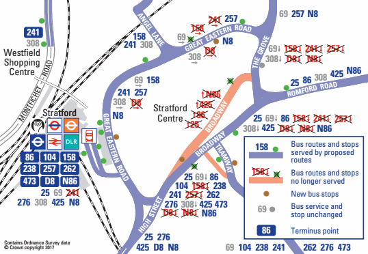
And here's what they're proposing. Simple, huh?
No?
Here's the same map, but I've removed all the red "routes no longer served" (and all the nightbuses).
That's still complicated enough, but let me see what I can unpick for you.
With regards to bus routes...
• Routes 69 and 308 won't be changing.
• Every other bus route is being partially rerouted to follow the same roads in both directions.
• Every bus route except the 69 and 308 will serve Stratford bus station in both directions.
• TfL have made a set of pdf maps to compare all the old and new routes.
With regards to new bus stops...
• Two new bus stops are being added on the inside of the ring road to serve buses travelling anti-clockwise.
• One of these will be opposite the bus station, and will be served by the 158, 241 and 257.
• The other will be near the Picturehouse, and will only be served by the 257.
• Another new stop is being added along Tramway Avenue, so there'll now be stops on both sides.
• The bus station is going to be reconfigured, with a new central loop and fewer stops at the roadside.
With regards to dead bus stops...
• The bus stop round the back of St John's Church will be removed because that bit of Broadway is being pedestrianised. All eastbound buses will stop further back outside the entrance to the Stratford Centre.
• The bus stop on Broadway outside the Town Hall will be removed. All buses will stop further back instead, either opposite the church or just round the corner on Tramway Avenue.
• The bus stop opposite the Theatre Royal will be removed, and the three remaining bus routes will stop further down Great Eastern Road.
And because it's still not entirely obvious what all that means, let me break it down by destination.
No change - all buses will go first to the bus station.
At the moment the best place to catch a bus to Bow is outside the Town Hall, because all four bus routes stop there. In future the best place will be the bus station, for the same reason. Only the 25 and 425 will stop on the Broadway.
No change - all buses will stop on Tramway Avenue and then go direct to the bus station.
Buses leaving the bus station will no longer loop round the gyratory but will take the quicker anti-clockwise route. Buses won't stop on Broadway, but at a new stop on Tramway Avenue.
The same route as now, but with a detour to the bus station and back. Apparently buses won't stop anywhere in central Stratford except the bus station, which is either madness or somebody's left a dot off the map.
The same route as now, but stopping at a new stop on Tramway Avenue.
The upshot is...
• Routes will generally be simpler and more direct.
• It's going to be easier to catch a bus to/from Stratford station.
• The bus station's going to be busier, and a more important place for catching buses.
• Far fewer buses will be serving the northeast of the town centre, i.e. outside Morrisons and the library.
In conclusion, I think I understand what's going on only because I've spent the last hour trying to unpick the maps and write the above summary. I wonder how many other people are going to bother, and then submit a response? It's all pretty much a done deal anyway... Newham are changing the roads, so TfL have got to change the buses. And sure, it's a big change, but we'll all get used to it eventually.
(In case a post about bus changes in Stratford was too much for you, there's always four days of writing about Tyneside to catch up on.)
The Metro is Tyneside's light rail system, a knot of lines coiled down the Tyne valley, initially opened in 1980. For a two line system it's oddly complicated - not the Green line which links the airport to Sunderland, but the Yellow. This is like the Circle line on steroids, with a giant northern loop out from Newcastle city centre to The Coast, and a long arm which crosses the river to terminate one mile from a station trains were at one hour earlier. It makes more sense when you're on it.
I struggled to buy a ticket from the machines at a station where the staffed Travel Shop had recently been closed. The Day Saver ticket was hidden down an unexpected route on the menu, so I had to ask the bloke by the barriers for help, then the machine couldn't read my banknote and cancelled the transaction, so I had to ask the bloke by the barriers again. "We're not supposed to come over and help," he said, "because management think the machines are self-explanatory. Also, try pushing your banknote along the left hand edge of the slot." We caught our train eventually, despite management's best efforts, and headed out to enjoy some sights downriver.
Wallsend (Segedunum)
WallsendMetrostation is the only public building in Britain with bilingual signs in Latin. Platform 1 is Suggestus 1, potential smokers are warned to Noli Fumare, and even the warning about penalties for ticketless travel has been translated for time-travelling passengers. This unique artwork exists because Hadrian's Wall ended nearby, or at least it did once extended east from Newcastle in 127AD, hence this point marks the edge of the Roman Empire. The site of the former fort of Segedunum is now a tourist attraction, complete with millennial Visitor Centre and airport-style observation tower. Take the lift to the ninth floor to view the footprint of the garrison, and the former site of the Swan Hunter shipyard, and (at present) five giant yellow towers destined to end up supporting an offshore windfarm.
Downstairs is a Roman gallery which explains the history of the fort and the civilisation that built it, and explains it well, then you can head outside and walk around. Only a few bits of excavated foundation remain, perhaps not surprisingly given that the site has in its time been part of a colliery and covered by terraced streets. Crossing the main road allows you to see what remains of the last few metres of Hadrian's Wall, which is basically a wiggly line of stones, plus a full-height reconstruction of what it might have looked like. There's also a reconstructed bathhouse with roof problems, sealed off at present, but the admission charge has been reduced by £1 to make up... and £4.95 is quite frankly a bargain.
The paradox of Segedunum is that it's excellent but empty. Despite being a sunny summer Sunday there were no more than a dozen visitors present, and that includes the three who left when we arrived and the four who arrived two hours later on our way out. My hunch is that everybody local who wants to see it has seen it, or has been round on a school trip, and the attraction lacks the gravity to lure wider tourists in. Whatever, a visit to Segedunum comes highly recommended, if nothing else to keep the lovely ladies in the cafe in gainful employment.
South Shields
There are two 'Shields' at the mouth of the Tyne, one North and one South, the latter being the larger. South Shields also faces the North Sea and has excellent beaches, so is the ideal destination for Tynesiders seeking a coastal retreat in high summer. We joined the crowds on Ocean Road heading to the promenade, passing timewarp guest houses with No Vacancies, a museum proud to be part of Catherine Cookson Country and an indoor pool built for inclement weather. On the other side of the funfair are an enormous stretch of golden sand and some scrappy dunes, liberally scattered with windbreaks, reddened flesh and beach cricket. At the end of one long breakwater is the skeletal Herd Groyne lighthouse, quite the landmark hereabouts, and beyond that another shining strand with rocks for scrambling. London has nothing half as good within easy striking distance.
A few marinas exist but the populace of Tyneside don't generally have the wherewithal to go messing around in boats, so yachts, cruisers and jetskis make only infrequent appearances. Instead the most popular means of water transport is the Shields Ferry, which crosses every half hour from jetties upstream, first operated in 1377 and now with considerably more modern craft. Seasoned commuters sit downstairs, whereas we one-offs can never resist a seat on deck, all the better to compare the modernised shores of South Shields with the historic slopes of North Shields. That and the ruins on the headland at the mouth of the river... which is where we headed next.
Tynemouth
Whatever preconceptions southerners might have of Tyneside, Tynemouth shatters them. Its high class Georgian terraces are somewhere Hampstead's residents would feel at home, and the central shopping street (or 'village') is much more Southwold than Southend. The station too is a cut above, a former terminus with a glistening canopiedroof (resembling several greenhouses), plus a chic weekend market filling both concourses. The headland is dominated by what's left of Tynemouth Prioryand Castle, in prime defensive position at the entrance to the estuary, and sheltered behind is a sandy cove accessed down a not-inconsequential flight of steps.
We queued in baking heat for fish and chips from Marshalls, the Fryery by the Priory, and were not disappointed... except by the "cheesecake in batter" which (of course) turned out to be more slab-of-Kraft then New York vanilla. Had there been more time we'd have explored the beaches to the north, including the nationally-acclaimed sweep of Longsands, the cove at Cullercoats, and ultimately the resort of Whitley Bay. Alas the Metro had other ideas and hiccuped, introducing an hour-long delay, so they'll have to wait. But blimey, Tynesiders are blessed by coastal treats, so easily accessed (most of the time) by train.