Let's take a walk along one of the City of London's B roads - the B500.
Here's a road sign which proves it exists, and that it starts at Holborn Circus.
This photo was taken on New Fetter Lane which is officially one end of the A4 (the very last few metres if you're travelling in this direction or 130 miles from Avonmouth if you're going in the other). Holborn Circus is a five-way junction, primarily where the A4 meets the A40, but also the meeting point of the B500 and B521. A statue of Prince Albert used to stand bang in the middle but in 2014 they nudged him onto High Holborn to improve traffic circulation. That's the B500 poking off to the northeast, or Charterhouse Street as it's better known.
It's not a historic road, despite its name, having been created in the 1860s at the same time as Holborn Viaduct. That carried east-west traffic across the Fleet Valley for the first time, which meant a separate connection was needed down to Farringdon Road (which now followed the line of the lost river below). Initially it was called New Street, somewhat unoriginally, but swiftly earned the better name Charterhouse Street because that's where it led. It's still very much a road on a slope.
A small City parklet has been squeezed into the sharp corner between Charterhouse Street and Holborn Viaduct. It's not especially exciting, more a patch of lawn surrounded by benches you can't sleep on, and the bins very much need emptying and the fountain's been switched off and drained, but it's well kept and the topiary's smart and it looks like it could cope with two dozen sandwich munchers of a lunchtime. A convenient Pret lurks immediately behind, weekdays only, shuts 3pm.
The first building on the northern side is 1 Ely Place, formerly a branch of Nat West but recently transformed into offices, which means bike stores and showers in the basement where the bank vaults used to be. Ely Place is an amazing street, a private Georgian cul-de-sac built on the site of the Bishop of Ely's medieval palace and still home to his 13th century chapel, but it's not part of the B500 so I can't explore it or tell you more. For similar reasons I won't be telling you about Saffron Hill or Shoe Lane which bear off further down.
Charterhouse Street has its very own Bus Stop M, served by route 17, although it's closed at the moment due to cable repairs on the other side of the road. The opposite bus stop is used by terminating services on route 25 if there isn't enough space on the stand on Holborn Viaduct. As for 17 Charterhouse Street this is the HQ of world-renowned diamond merchants De Beers, a total fortress and very recently refurbished. Very soon we reach Farringdon Street, the valley-bottom road which Charterhouse Street crosses.
Unfortunately the B500 stops here because the remainder of the road has been declassified. That's a shame because the next stretch is fascinating, and also in flux as the Museum of London prepares to move into Smithfield Market, and those refrigerated warehouses have seen better days, and look there's Fabric nightclub, and yes it smells of meat, and here comes historic Charterhouse Square. Alas I'm blogging none of this because the B500 runs for only 150 metres so that's all you get.
No, I won't be introducing Random City B Road as a regular feature.
The main reason for this is that there are only three B roads in the City of London.
B100: Beech Street → Chiswell Street → Finsbury Square → Sun Street (0.6 miles) B400: Chancery Lane (0.3 miles) B500: Charterhouse Street (part) (0.1 miles)
They're an interesting trio but also rather short. I like how they're all multiples of 100. This is mostly (but not entirely) coincidental. Also two of the B roads merely run along the boundary of the City rather than through it, the sole exception being the B100.
Four further B roads start on the City boundary but run entirely outside it.
B134: Alie Street → White Church Lane → Osborne Street → Brick Lane (0.9 miles) B144: Bunhill Row → Bath Street → Shepherdess Walk → Eagle Wharf Road (1.1 miles) B501: St John Street (0.7 miles) B521: Hatton Garden (0.3 miles)
There used to be six more City B roads, all since declassified.
B128: Gresham Street (0.3 miles) B129: Fore Street → Red Cross Street (0.3 miles) B130: Old Broad Street (0.3 miles) B131: Lombard Street (0.2 miles) B132: Lower Thames Street → Upper Thames Street (1.2 miles) B133: Arthur Street → Monument Street (0.2 miles)
A lot of roads in the City were declassified in the 1990s when the Ring of Steel was introduced. The B129 was lost in the redevelopment of the Barbican. The B132 was reclassified as the A3211 when it became a dual carriageway.
A1: Aldersgate Street (396 miles) A3: London Bridge (78 miles) A4: New Fetter Lane (130 miles) A10: Bishopsgate (100 miles) A11: Whitechapel High St (62 miles) A40: High Holborn (263 miles)
A201: Farringdon Street (3.5 miles) A300: Southwark Bridge (1.1 miles) A501: Moorgate (4.5 miles) A1211: London Wall (1.3 miles) A3211: Victoria Embankment (2.4 miles)
A1210: Mansell Street (0.4 miles) A1213: Gracechurch Street (0.3 miles) A4208: Shoe Lane (0.3 miles)
The City is the only district in Great Britain to contain A roads starting with 1, 2, 3, 4 and 5. It's also the historic centre of the road numbering network. The A3, A10, A11, A40 and A501 used to converge at Bank, with the A1 and A4 starting close by.
#nerdfactOriginally the B500 ran along the north side of Smithfield Market, the B501 along the east side, the B100 along the south side and the A201 along the west side (three different starting digits for roads around a single building is unique).
One does not simply walk into Thamesmead. It skulks within an unbridged bend in the Thames, hemmed in by brownfield, warehousing and dual carriageways. Great things were planned for it fifty years ago, but only by those who'd never live there. It's somewhere you visit deliberately, rather than passing through, so all too easily overlooked. It's also inexorably changing, which is why it's always worth going back.
Unsurprisingly the sub-neighbourhood getting the biggest regenerative kick is the swathe closest to the station (not that much of Thamesmead is anywhere near a railhead, but Abbey Wood will be bringing purple trains a short walk to the south). A gaudy gold-clad tower coupled to a large Sainsburys arrived first on the Greenwich side, but the main action is now across Harrow Manorway within the London borough of Bexley. All the concrete flats facing the road have been summarily demolished and the only building beyond the roundabout is a Marketing Suite & Discovery Centre painted with the slogan Today. Tomorrow. Together. Yeah right.
To get an idea of what'll be coming next head closer to the lake, to Southmere, where developers Peabody have been intermittently busier. This used to be TavyBridge, the iconic corner with the raised concrete piazza and terraced flats looking out across the water. It may have looked photogenic in cinemascope, for example at the close of Beautiful Thing or during the waterfight in A Clockwork Orange, but in real life there was little alluring about a minor shopping parade above a car park whose chief offering was a Costcutter.
The new flats look exactly like you'd expect them to, generically brick-clad and taller than what was here before. Not many are yet habitable which is how I found myself walking up an alley between a few front doors and a building site, disconcerting one vest-clad resident who evidently wasn't used to passers-by. Thamesmead's original architects eschewed ground level entry for fear of potential Thames flooding, but the new lot don't seem to be as worried.
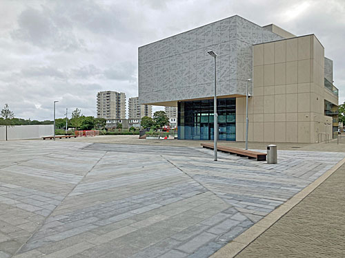
The estate's new centrepiece is Cygnet Square, an irregular piazza leading down towards the lakeside. It's finished but not yet activated, so essentially a dead space at present, boasting a few benches facing nothing much, some lampposts, a litter bin and a tree. It was supposed to include a large central water feature but that got scrapped to save money and the drear end result is austerity writ large. The three-storey building alongside is The NEST, Thamesmead's new library, or in developerspeak a hub promoting resident wellbeing. I wouldn't quite go so far as describing it as "stunning" or "eye-catching", but compared to the temporary shack that's been dispensing books for the last few years it's a gamechanger.
Binsey Walk, where Kubrick filmed Alex and the droogs strutting by the water, is sealed off and has been for several years. Last time I was here in 2018 they'd just decanted the residents and were preparing to knock everything down, which I can confirm they have now done, although at least the steps down into the lake haven't been dug up. When fresh flats arise rather more people will have a view of the lake, but they'll also need to be relatively better off than the original tenants. Even Thamesmead is desirable now, who'd have thought.
Thankfully it's still possible to walk round the lake the other way, past a freshly spruced-waterfront boasting a brightly-coloured pontoon. This sticks out just far enough to get a good view of Cygnet Square and the blocks rising behind, augmented by a line of plants corralling some waterfowl, as if installed by someone needing photos for a promotional brochure. It contrasts starkly with the last lakeside concrete terrace on Portmeadow Walk, not to mention the four 1970s tower blocks on the elevated grey walkway beyond. This still looks like somewhere C4's Misfits would have caused trouble, unlike the new stuff which won't be on any location manager's shortlist.
The far side of the lake remains the realm of geese, so watch where you tread, but has also been smartly upgraded with a rim of green. Take fresh paths down through fresh meadow to a series of fresh jetties poking through fresh waterplants, all the better for watching the ducks, geese and swans. The developers have done a good job here. Further round is the former Lakeside Centre, since appropriated as an arts centre by my local gallery (who seem intent on cultural takeover in suburbs far beyond Bow). This squat concrete building always seems to be locked and unnapproachable when I walk past, but at least the security van with its growly dog has been sent packing.
Don't get the wrong idea, the vast majority of Thamesmead looks exactly the same as before, and there's a heck of a lot of it between here and the Thames. But great change is afoot betwixt the lake and the station, in this visionary suburb that's been becoming architecturally less adventurous with every evolution. It pays to drop in and explore sometimes, ideally before all the memorable stuff gets whipped away.