Somewhere sporty: Guildhall The City of London isn't renowned for its sport. There's a swimming pool and a bowling green, and there are several gyms catering to pumped-up financial whizzkids, but there's not really enough room for any major sporting facility. Thankfully, for my purposes at least, this wasn't always the case. 20 centuries ago Londoners flocked from across the City to the site now occupied by the Guildhall for a regular fix of sporting competition and general carnage... because here was the original Roman Amphitheatre.
The Guildhall is the City's seat of local government, and has been since the 15th century [photo]. Entrance to the magnificent medieval Great Hall is free, via the modern administrative block nextdoor (architectural verdict: not lovely). Guildhall's stone walls are (mostly) original, but alas the ornate oak-panelled roof is a post-1941 copy of a post-1666 copy. The hall hosted the trials of both Lady Jane Grey and Archbishop Cranmer, amongst others, and every year the new Mayor's inaugural banquet is held here. Banners representing the 12 great Livery Companies hang beneath the ceiling, as befits the historic headquarters of a ceremonial organisation whose wealth grew out of mercantile trade. Beneath the Guildhall there's the largest medieval crypt in London, while nextdoor there's a rather more recent Art Gallery... which holds a secret.
It's set procedure when erecting a new building in the City to invite archaeologists on site to dig down and check that nothing of ancient importance is about to be obliterated. And so in 1988, when preliminary soundings were being taken for the new Guildhall Art Gallery, Roman remains were unexpectedly discovered in four separate trenches. On joining all the clues together experts realised that they had a major find on their hands - the eastern entrance to London's long lost amphitheatre. Construction of the art gallery was put on hold for five years while plans were redrawn. The curving perimeter of the arena was marked out in black paving slabs around the Guildhall courtyard above [photo], and the new gallery finally opened in 1999 with a restored ancient monument in its basement.
A visit to the Art Gallery will set you back £2.50. For this you get to look at some fine paintings upstairs and entry to the Amphitheatre chamber downstairs. To be honest there's not much to see, just a few chunks of lumpy stone wall [photo], but they've been sympathetically presented within a long dark space. Illuminatedgreen silhouettes provide a sense of scale, if not of history. Cross the line from the 'seating area' into the 'arena' and the sound of cheering fills the air (it was actually recorded at an England football match, but don't tell anyone). At your feet is a preserved wooden drain, used to empty the arena of rainwater and other, rather redder, liquids.
It's not easy to stand here today, beneath the ground, and imagine the amphitheatre as it used to be on the surface. An elliptical stone wall decorated with intricate marble inlays. Travelling gladiators battling one another across the arena. Frightened animals despatched with bloodthirsty brutality. The regular public execution of convicted criminals. 6000 spectators roaring down from rows of tiered wooden seating. And it all happened here, right in the civilised heart of the modern City. Come and see. by tube: St Paul's, Bank, Moorgate by bus: 100
Somewhere retail: Leadenhall Market The City of London was established on trade and commerce. Everywhere you look there's somebody selling something to somebody else, be it commodities, financial services, insurance or that strange economic spread betting which burns out sharp-suited City dealers long before their planned early retirement. So it's not surprising that there are, or were, markets everywhere across the Square Mile. Smithfield for meat (still going strong), Billingsgate for fish (now relocated to Docklands) and Spitalfields for fruit and vegetables (now relocated to Leyton) are the most famous of these. One other longstanding retail centre is Leadenhall Market, tucked away atop Cornhill on the site of what used to be Roman London's forum. The original 14th century market specialised in meat, game and fish, and attracted Poulterers and Cheesemongers from across the southeast. It sounds a bit like modern Borough Market, only without the olives and chorizo sausage.
In 1881 Leadenhall Market was reorganised and the buildings replaced by the stunning iron and glass arcade we see today [photo]. Ornate painted columns support four arched roofs which meet at a central octagonal skylight [photo]. All available surfaces are decorated, mostly in maroon and gold, and Victorian lanterns hang from the ceiling. Unfortunately appearances can be deceptive. Whilst some of today's shops still sell meat, cheese and fish, many others are now just average shopping mall fodder. Look, that's a Pizza Express, and that's Cards Galore, and over there is another outbreak of expensive coffee. The remaining marketpubs are better, so I'm told, but they (and every other shop here) were closed on Saturday and the arcade frequented only by inquisitive tourists wielding cameras. I hope that the character of this charming conservation area can survive the retail assault of 21st century London, and I must go back later (on a weekday) to check. by tube: Bank/Monument by bus: 35, 47, 48, 149, 344
THE UNLOST RIVERS OF LONDON River Rom Stapleford Abbotts → Romford → Dagenham (6 miles)
[Bourne Brook → Rom (+ Ravensbourne) → Beam → Thames]
Well what did you expect the river that flows through Romford to be called? It's a long one too, given three different names on its downhill journey. The River Rom rises just beyond the M25 as the Bourne Brook, a dully tautological name, but thankfully that's in Essex so I've not got to walk that bit. Three miles down, in the village of Stapleford Abbotts, it turns south and transmogrifies into the Rom. Then below Romford, at the confluence with The Ravensbourne (no, not that one), it changes its name again to become the Beam River. This last three mile stretch perfectly defines the border between Havering and Barking and Dagenham, which just goes to show how crucial rivers are in defining modern London. Checking on a map before I set out I assumed I'd be walking a lot of the route along roads, but this turned out not to be the case because there were extensive riverside paths. Indeed what I'd been expecting to be a trifle purgatorial proved anything but, although I doubt the riverbanks would be quite so welcoming in February. [10 photos]
Stapleford Abbotts is the first village out of London on its far northeastern rim, located a few dips beyond Havering-atte-Bower. As such to reach it requires travelling on one of TfL's least frequent buses, the 90-minutely 375 from Romford, and some carefully coordinated scheduling. About half of the passengers on the post-shopping run alight in H-a-B, while the rest of us continue to the straggly strings of mostly modern houses that define S A. The Bourne Brook has its own bus stop, which is more than this trickle of water between cottages rightly deserves, and its own lane which doglegs off towards Lambourne End. The stream next appears at Bourne Bridge, as a barely perceptible feature, and it's from this point down that the river is officially known as the Rom.
A footpath tracks the Rom's first few hundred metres, running up the side of a house with horses, then across a field littered with evidence of their diet. Within a clump of trees two narrow footbridges lead across a tributary (the Spurgate Brook) and then the main stream, now at least with perceptible flow. The next mini footbridge may not look significant but it's where London begins, as can be deduced by the Essex-style footpath marker on one side and a Havering-esque roundel on the other. Alas by now the river has darted off across private land, the local landowners confining ramblers to a narrow strip of grass between paddocks so that their horses can safely graze.
You'll know the next bit if you've ever walked London Loop section 20, ascending a low hill along the wooded edge of Havering Country Park. There's also a fantastic view across central London, from the spiky Dome and dense Docklands cluster to the familiar silhouettes of the South Bank and City. I've trained my camera on the horizon, across the green indentation of the Rom valley, and very definitely not on the farmer and his family out inspecting the horses at the foot of the nearest field. Nevertheless I'm unnerved to see his Shogun slowly ascend the slope, pull over alongside and wind down the window for a chat. In the awkward conversation that follows he moves from outright suspicion to inviting me to pop down to the farm to share the negatives, and I think we're both equally relieved as the other moves on.
That's it for fields. The Rom hits built-up London alongside Carter Drive, where some suspiciously young lads in baseball caps sit in souped-up motors waiting for me to get out of the way. This is Havering Park, a low-spec interwar estate which would have swamped the valley to the north had not the Green Belt been slapped down. I'm expecting to have to walk the streets but was pleased to find a freshly-mown waterside path to follow between the backs of tiny gardens - the Collier Row Green Link. The river is barely visible beneath lush billowing vegetation, a more than pleasant scene which will be repeated at several other points downstream. And yet absolutely nobody else is out taking advantage of this half mile natural amenity, presumably because local residents are more car people than walkers.
I enter Collier Row Recreation Ground behind a trio of young girls leading their toddler brother towards the playground. "Run!" they shriek, "the old man's going to get you!", and the littl'un runs with all his might. It's a very friendly borough, Havering, so long as you fit in. The Rom gets a namecheck on the bridge at Collier Row Road, flowing through its first drab concrete channel between a builders' merchant and the Gospel Hall. And then it dashes off across inaccessible nomansland, past allotments and the back of a school playing field, so please bear with me while I walk fifteen minutes of pavement.
King George's Playing Fields are a triangular kickabout space, seemingly for the walking of dogs around the perimeter, with the Rom forming a decorative border along one side. Approaching the 'Teenage Area' the river looks at its most normal, a shallow brook overshadowed by trees, with the mandatory blue rope dangling above the shoals. And then the river escapes again, ducking beneath the Eastern Avenue dual carriageway to enter a wedge of retail sheds to the north of Romford town centre. The cul-de-sacs leading off North Street have names like Brooklands Approach and Riverside Close (very close, if you live in the latter).
Romford has learned to be cautious of its namesake river. In August 1888 the Great Flood inundated the High Street to a depth of several feet, destroying shopkeepers' stock and washing thirty thousand beer barrels far downstream. It took the town six months to clean up, and the disaster finally spurred the council to build better drainage across the town. In the 1950s the Rom was reengineered as a deep concrete channel, with what looks like a slightly-raised footpath to one side, the banks now much beloved by grafitti artists. Meanwhile the section between the ring road and the railway was permanently culverted, much of this stretch now covered by The Brewery superstores complex, or more accurately its car park. Little do they realise as they hunt for a parking space, or take the scenic escalator to the cinema, or waddle into the Toby Carvery, that the town's namesake river lies beneath.
The Rom reappears beyond the viaduct, still tamed by concrete, emerging to public view on the ring road (round the back of an office building which, damn, I've been trying not to revisit for over 15 years). The river has been honoured with its own streetname, Rom Valley Way, and consequently by the Rom Valley Way Retail Park (which boasts both a Mothercare and Carpet Right). It's a shame there isn't a computer warehouse for some wag to name Rom ROMs, but the river always feels tolerated rather than celebrated round here. And then we're at Roneo Corner, named for the Roneo Vickers factory that once stood here, now an extra-busy road junction. It's here that the boundary with Barking and Dagenham feeds in, and continues to the Thames, but we'll do that tomorrow if you don't mind. Or even if you do.
For my next alphabetical visit to unsung suburbs we're off to Farnborough, not the Hampshire town with the air show but the former Kent village on the outskirts of Orpington. What a lovely place to live; convincingly rural, urban-adjacent and suitably bypassed.
Farnborough has Norman roots and grew up astride a ridge on the main road from London to Sevenoaks. A bit further on than Locksbottom and not quite as far as Green Street Green, if that helps you locate it. The name means 'village among the ferns on the hill', or did when that name was originally Fearnbiorginga. For many years it boasted several coaching inns, then on 13th April 1927 a bypass was opened for which current residents are extremely grateful, publicans excepted. It's now a quaint linear village on the brink of the North Downs, but with a wedge of suburban infill on the bypassed flank which helps sustain a busy community, so essentially the best of both worlds. If you've ever walked London Loop section 3 you'll have seen this for yourself.
In the middle of the village is a triangular space faced by rows of cottages and a mortgage broker. The central greenspace has all the obligatory parochial features - a village sign, a flagpole, some benches around the base of a tree and one of those flat silhouettes of a WW1 soldier with his rifle planted in the ground. A small flowerbed has been immaculately planted with bright bedding plants, all of which looks uplifting until you spot that the sponsor is the local mausoleum, or as the business-speak puts it "the UK's first indoor above-ground burial facility". Renting a niche for your loved one starts at £40 a month, rising to £93,555 for a 99 year lease on a family vault.
Villagers have been particularly good at placing informative plaques beside points of interest, for example outside old inns and alongside the village pump. That's a nice old pump I thought, then I read more carefully and learned it's not the original (they bought it at auction) nor is it on the original site, instead positioned on some incongruous grass where the village pond used to be. Another plaque, nudged into a picket fence, points out the prominent site of an 18th century coaching inn called The George. After the bypass was built it became a pub called The George and Dragon, then in the 1970s merely a restaurant and more recently a small millennial housing development. It's a little odd to be looking at a black and white photo of bowler-hatted passengers in horse-drawn coaches while in front of you a window cleaner is up a ladder using his squeegee on replacement uPVC windows.
Two former coaching inns survive - The Woodman and the Change of Horses (formerly known as the New Inn). Coach drivers would stay here overnight, their horses put out to pasture in the field opposite, while passengers were instead accommodated in greater comfort at The Whyte Lion up the road in Locksbottom. Today both Farnborough pubs lure in their punters with Craft Beers and Home Cooked Food, and in one case Dog Friendly Quiz Nights (although on closer inspection that's probably two attractions). I note that The Woodman's somewhat unadventurous menu tops out at £15 for 'Trio of sausages' whereas the Change of Horses' longlist stretches to £21 for 'Ultimate Pie of the Day', so I'd suggest your palate would probably prefer the latter.
The shops are decent, along a parade that's patently been extended as the size of the village has grown. The only chain in sight is Londis where the Post Office still resides, while elsewhere you can get your bike fixed, your nails done and some brunch cooked. The village barber is called Ieuan and the village delicatessen is run by Nanny Smith, although I suspect that may be a pseudonym. Birds Tea Rooms are sadly long gone, this the preferred refreshment opportunity for the weekend crowds that started flocking from London after the number 47 bus was extended to terminate here in 1913. As for the former bank, seemingly much too large for such a small village, it's been cleverly repurposed as the local doctors' surgery. The blacksmith's cottage nextdoor is creepily overdecorated, this because it's been converted into what looks like an exuberantly twee antiques shop.
10 Farnborough nuggets
• Farnborough's main road is one of London's 57 High Streets.
• The village green alas got turned into a road junction, it's where the bypass bears off.
• A milestone near The Woodman confirms 'London 14 Sevenoaks 10'.
• This being ex-Kent yes, there is a converted oast house.
• I spotted a private cul-de-sac called Strawberry Fields, but no Penny Lane.
• Farnborough Old Boys Guild FC lost five nil to Otford on Saturday.
• The village hall hosts Karate, am-dram, bridge, pilates and two W.I.s.
• The cottage with the tiny front door on Church Street is called Little Door Cottage.
• It's a 25 minute walk to Orpington station up Tubbenden Lane.
• Wikipedia says Nigel Farage was born in Farnborough, but that may just be because Princess RoyalUniversity Hospital in Locksbottom is technically in Farnborough parish.
For the best part of Farnborough you have to head south down Church Road, this leading unsurprisingly towards the church of St Giles The Abbot. It's impressively old and flinty, the main portion of the nave dating back almost 900 years, and topped by a typically squat Kentish spire. Even if you have to make do with the exterior it's pretty impressive, including a large graveyard, the village war memorial and a seriously chunky yew tree planted in 1643 after a particularly ferocious storm. The grave to hunt for is that of Urania Boswell, better known as ‘Gipsy Lee’, whose ostentatious Romany funeral procession in 1933 was memorably captured by Pathé News.
Below the church the land opens up and drops away into open countryside, a boon for every local dogwalker, or you can thread down through a strip of woodland instead. At the foot of the slope you enter High Elms, now a 250 acre country park but originally the country seat of the Lubbock dynasty. The 4th Baronet, John Lubbock, was one of the more consequential Victorian politicians. It was he who introduced the Bank Holidays Act to Parliament in 1871, also the Ancient Monuments Act in 1882 which preserved Stonehenge and Avebury, also he who coined the words coined the terms "Palaeolithic" and "Neolithic", also a founder member of the Electoral Reform Society, also Chairman of the London County Council, also President of the Royal Statistical Society, also a childhood friend of Charles Darwin who lived a short distance away at Down House. Not bad for a posh boy from Farnborough.
Today you can wander freely round his estate, other than the chunk that's become a golf course, exploring chalk slopes, ornamental gardens and deep woodland. Alas the big mansion burnt down in 1967 and the site is now a flat lawn surrounded by all the original terraces and shrubbery so quite an eerie prospect, not least the drive that sweeps up to a crescent of tiles laid outside the kitchen door. Closer to the car park Bromley council maintain an outdoor education centre complete with beehives, dipping pond and nature trail, although you have to come at the weekend to pick up local maps and trail leaflets. The cafe was proving very popular, even midweek, although I'm not sure the ladies who lunched really wanted the wild boar burger in a brioche bun at the top of the specials board.
It seems extraordinary that this is part of our capital city, but that's F in London for you.
Going back to my roots: Croxley Green, Herts
my family, 1930s-1990s
All of which ancestral wandering brings me back to the village where I grew up. OK, so it's a bit of a cheat pretending that a commuter town with a population of eleven thousand is a village, but in comparison to neighbouring Watford the place is positively rural. Croxley Green lies in the southwest corner of Hertfordshire on the edge of Metroland, so you may have seen the place lovingly revered in John Betjeman's definitive 1973 documentary.
"Child of the first war, forgotten by the second, we called you Metroland. We laid our schemes, lured by the lush brochure, down by-ways beckoned, to build at last the cottage of our dreams, a city clerk turned countryman again, and linked to the metropolis by train."
My music teacher appeared in Metroland, conducting the school orchestra at Croxley's annual "let's pretend to be a village" village fair. I'm relieved that John and his BBC camera crew didn't turn up three years later because that was the year I was selected as one of the 24 maypole dancers, and wearing short trousers on television isn't good for one's street cred. I did wonder whether my maypoling had been immortalised on the new village sign, but closer inspection revealed that all of the twirling silhouettes are female - damn.
I could write at least a month's worth of posts about CroxleyGreen but I won't (I'll save that for some year in the distant future when I'm determined to haemorrhage readership). Today I'll just content myself with a report from the site of the village's most famous export. Right opposite the house where my dad grew up.
This is Common Moor Lock on the Grand Union Canal. Just over 70 years ago my newlywed grandparents moved into a Metroland semi on the banks of the canal here (hidden behind the trees to the left at the rear of the photo). Their lovingly-tended garden sloped down to the canal towpath at a gradient of 1 in 5, so it was all the more impressive that I chose their lawn to take my very first toddling steps. I wouldn't risk it today because the latest owners appear to have abandoned a car at the bottom of the garden, next to a pile of bricks and some rusty wire fencing. Looking out across the canal there used to be a fine view of the John Dickinson Paper Mill, home of world-famous CroxleyScript paper. Bet you've used it. DH Lawrence swore by it. I remember the huge mill buildings well, standing sheer above the canal like an industrial cliff face, but alas they no longer stand. 150 years of paper production ceased in 1980 and the site (right of photo) is now covered by a swathe of modern housing - with tiny flat uninspiring lawns.
According to the Ordnance Survey there are eight hamlets within the boundaries of Greater London, of which five are in the borough of Bromley. Over the weekend I visited two of them in the hinterland between Orpington and Swanley.
If you only saw this view of a row of houses you might think Hockenden was nothing unusual. But beyond the hedge on the other side of the lane are paddocks and open fields rising to beechy woodland on a windy ridge, because Hockenden is a hamlet strung out along a country lane and somehow all of this is in London.
The lane swings in from Upper Hockenden which is very much part of Swanley and very much in Kent, but the Greater London boundary now follows the bypass and Hockenden finds itself on the London side. You either drive in or you find the narrow footbridge over the A20 and descend down Trunks Alley past the discarded Asda trolleys. Here we find a couple of makeshift homes sealed behind fierce security gates with spikes and flashlights, plus the first of several Beware of the Dog signs and a field where horses bide their time while not being ridden. The houses look a bit more normal past the speed limit sign - see first photo - although the owners have a habit of calling them cottages because we're in the countryside now. One with eight bedrooms ("located on a generous plot in a semi rural location") has just sold for a million.
The centre of the hamlet might be the triangular patch of grass where the postbox is, with its misaligned fingerpost and friendly sign saying Unsuitable for heavy goods vehicles, or it might be a bit further round the corner past the cottages under renovation and the high hedges and the collapsed fence. This is where the big farm and the big house are, not the original manor but a listed weatherboarded 18th century farmhouse, again with twiddly gates and a warning about a dog. Part of the farm is now a Construction Academy where you can accredit digger-related skills and part still has the remains of an oast house and a row of hop-pickers' cabins. I think I met the owner because he asked if I was looking for something in that way you test out strangers, so I swiftly moved on.
A couple of public footpaths lead off Hockenden Lane, though from what I saw you might have to negotiate past youths on trail bikes along the way. Walking out is more direct than driving, especially now that Star Lane has been obstructed by concrete blocks to prevent fly-tipping. Technically this is where the Low Emission Zone starts, but one joy of living in Hockenden is that you can own a belching jalopy and not pay a penny to the Mayor so long as you do all your shopping in Kent. The southern end of the hamlet goes by the name of Hogspring, for archaic reasons, and boasts yet another set of stables and some heavily fortified bungalows - ideal for those who want to live in the countryside without seeing it.
But the most remarkable thing in Hockenden lies just around the last bend tucked away within the woods. All you can see from the road is an automatic gate labelled Brocken Hurst and a nameplate depicting three shapely human silhouettes, and beyond that a flowerbed and a timber screen. But there is a very good reason why nobody wants you looking in and that's because this is one of Britain's largest nudist camps. The North Kent Sun Club established itself here in 1958 amid 45 acres of chestnut woodland, and today the Naturist Foundation run events and camping holidays for those who think bare is beautiful. They have a newly-refurbished swimming pool, extensive games courts and a pavilion with cafeteria and bar, not to mention by the looks of it a fabulous carpet of bluebells preparing to erupt just in time for next month's 5K Fun Run. There's a lot more to this hamlet than meets the eye.
A mile south of Hockenden, down Sheepcote Lane, lies the additional hamlet of Kevington. The Ordnance Survey thinks it's called Kevingtown but the 'village sign' is sure it's Kevington, which is only fair because this hilltop cluster has nothing towny about it. The 'village pub' also used to be the Kevington Arms so there's further proof, although it's now a private residence called Blueberry Farm and very much not a farm either. What we have here is a staggered crossroads with a few houses on three of the arms, again nominally cottages but these have a stronger architectural claim. Residents seem less likely to keep horses than those in Hockenden, more likely to lovingly tend their gardens and collectively proud enough to have erected a millennial sundial, suggesting Kevington's a more cohesive community.
The main road from St Mary Cray to Crockenhill runs straight through, which is good because it means Kevington actually gets a bus service. They may be TfL bus stops but the 477 is not a TfL service, just a Kent bus delivering shoppers to Orpington, Dartford and (until Easter) Bluewater. A scrap of pavement runs down one of the hills, but only far enough to aid the postman and then you're on your own in the traffic. Signs warn of Tractors turning, which seems fair because one did chug past at a decent lick.
At the foot of the hill (but tucked safely out of sight) is Kevington Hall, a Georgian pile built for one of the directors of The East India Company. In its time it's also been used as a primary school and to billet Canadian troops, and has since been snazzed up as a wedding venue and conference retreat (now taking bookings into 2023). Their website describes the hall as "one of Kent’s best kept secrets", perhaps because it isn't actually in the county but instead nudges up against mundane semis on the outskirts of St Mary Cray. Best not tell guests there's a low secure hospital for young people with mental health, behavioural or psychological difficulties nextdoor (latest Ofsted report - Outstanding), because Kevington too is full of secrets.
RANDOM BUS(part 2)
Route 493: Tooting - Richmond Length of journey: 13 miles, 95 minutes [map]
Let's wrap up my latest randomLondon bus route by completing the second half of the journey (from Wimbledon to North Sheen). [part 1]
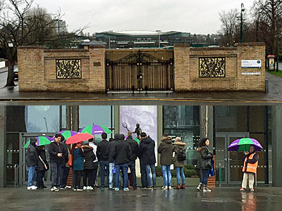
Wimbledon Tennis Club and Museum: Officially it's the All England Lawn Tennis and Croquet Club, but the bus stop outside dumbs down that title somewhat because the whole thing wouldn't fit. The 493 is the only bus to serve this premier sporting location, unless the tournament is on in which case it's diverted elsewhere for fear of getting stuck in the crowds. For the rest of the year there's a museum to visit, and a cafe, and a shop where various purple and green accoutrements are yours for a price. Or you can go on a tour, which the bunch of mostly foreign tourists I could see through the gate seemed to have been enjoying despite the rain. I left them to it, and decided to go for a walk round the site, which soon proved considerably larger than I'd been expecting. The walls break occasionally at gates allowing sight of tightly-packed outside courts and refreshment/toilet facilities for the throng, and the occasional midwinter employee scuttling between blocks. One of the best views is at the southern tip of the site where the contours rear up, while a few residents on Somerset Road have installed extra large roof-level balconies to provide an overview of summertime action.
Round the back of the club the road rises gently to pass hospitality and media facilities, and lonely-looking security guards, and a large separate block of indoor courts for when the weather's like this. And the road keeps climbing - no shortcut possible when the car park's closed - leading further and further up into residential nirvana. Some extremely desirable properties lurk up here on the hillside below the common, along almost-private roads on leafy plots with acres behind. The occasional 4×4 justifies its expense by powering up a single track hill, to pull in onto the gravel beside some gabled hideaway. The eventual descent emerges beside the AELTC's immaculate croquet lawns, several of them, perhaps a little muddier than usual at this time of year. To return to the bus stop requires a further trek past the practice courts, and the emerald spaceship of Court No 1, a full mile and a half complete. Best don't consider following in my footsteps, there's a reason Fortress Wimbledon looks better on the telly.
A long gap between 493s means a lot of people on board, although I do manage to grab a seat near the front where the bright young things have left space for the elderly. This proves fortuitous, because the windows have almost completely steamed up and the only available porthole is through the windscreen at the front. Trust me, there is nothing worse on a bloggable bus journey than not being able to see out of the window, and a blinkered view is at least better than none at all. We reach Southfields station, where a sharp left has the old lady in front of me grabbing hold of a pole for stability, before turning again to tour the Southmead estate. Blimey, how London's residential nature can change in a street or two, from highly desirable to towers of flats. "Do you stop at the shops?" the old lady asks the driver, and yes in this direction we do, so off she steps a minute later. A brief spell on the busy A3 ends at Tibbet's Corner, a once-rural glade despoiled by a split-level roundabout, and then we tour the top edge of Putney Heath. I'm aware that there's much more to explore here, from the bus village at the Green Man to the duelling grounds in the woods, but very little is visible through the smears. I resolve to alight immediately ahead, to switch to a vehicle less wreathed in condensation.
Danebury Avenue: I have three minutes before the next bus arrives, which is just long enough to check out one of my favourite corners of Roehampton. The AltonEstate is a landscaped concrete masterpiece, or a failing community, depending on which viewpoint you believe. Wandsworth Council have a masterplan in place to regenerate the unlisted area round the shops, details of which can be seen on consultation boards stored against the window of the library. But this means the library's likely demolition, along with slab block Allbrook House which looms above, and the adjacent Alton Activity Centre. A poster taped up in the bus shelter alerts residents to campaign groupAlton Regeneration Watch who are concerned that local democracy is being overruled and that current residents might well be losing out. It's an increasingly familiar story across London, and I worry that next time I visit Danebury Avenue the library, the laundrette and The Right Plaice might be on their way to being replaced by something incomers would prefer.
The next bus is bunched up so close to the previous service that it has barely half a dozen on board, and so my 360 degree panorama is restored. Progress through Roehampton is horrifically slow, thanks to a set of temporary traffic lights installed courtesy of TfL's Road Modernisation Plan. An ambulance is parked up at a bus stop near Queen Mary's Hospital, alongside a 493 going nowhere in the opposite direction. On closer look I spy a stretcher on the pavement, and paramedics aboard the bus escorting a passenger to the door, on a journey that unexpectedly stalled, and hopefully turned out OK. Coming up next is Rosslyn Park RFC, one of the many rugby clubs that have relocated to southwest London over the years, its pitch busy with action but surrounded by sheds.
Ahead lies Barnes Common, where we turn left onto the Upper Richmond Road, which we'll be following all the way. Other than the bridge over the Beverley Brook, this is wholly unfamiliar territory, and I'm grateful to the 493 for bringing me somewhere unexpectedly new. Specifically that's East Sheen, a well-to-do Victorian neighbourhood, one step back from Mortlake and the river. Sheen is the original name for Richmond, and slips easily into various shop names including Sheen Sports, Sheen Tyres, The Sheen Cobbler and (my personal favourite) Sheen Beauty. We have a new passenger, a retired gentleman reading the FT, who has one of the loudest most theatrical coughs I've ever endured. I'm hoping his behaviour is merely an affectation, until he whips out a paisley hanky and fills it, before returning to the business news and coughing on.
Here's an oddity, a bus stop labelled with the terminus point for the route a full ten stops before we actually get there. North Sheen station is barely 200m up a sideroad, whereas we'll be nearly quarter of an hour in getting there via the jammed centre of Richmond. Regular passengers know to get off the bus on Sheen Road and walk to the shops from there, whereas those who stay on get to tour the one-way system, much longer in this direction than the other. This brings us to Richmond Bus Station, more an afterthought than a facility, where umpteen services flood in to a single bus stop before queueing to rejoin the melee on the main circuit.
The Museum of Richmond: It suddenly strikes me that I've never visited this borough museum, which is remiss, although perhaps understandable. It's hidden two floors up in the Old Town Hall, accessed via a door down a passageway by the toilets, hence it's a pleasant surprise to discover a lengthy gallery round the final corner. Richmond, it's soon clear, has a vast amount of proper history as opposed to, say, the nothing much of Barking and Dagenham. Richard II lived in a manor by the river, before Henry VII built a magnificent royal palace and named it Richmond after his ancestral Yorkshire castle. He died here in 1509, as did Elizabeth I a century later, before Cromwell's men demolished almost everything, indeed a lot of what's catalogued in the museum has been swept away. The borough also has claims to fame in the worlds of theatre and petrochemicals - rayon was first synthesised in Kew - while North Sheen was the site of London's first council housing, way back when this was properly Surrey. The displays have a dated feel, but the information shines through, and even the latest WW2 exhibition manages to personalise the topic above the parochial. Closed Sundays and Mondays.
And finally, time to head back east on the 493 to North Sheen. My final vehicle is mostly empty but evidently recently packed, hence the curse of the steamed up windows has returned. That's OK, I've seen Richmond's high street before, on the slow chug up to the station and beyond. There are almost as many buses as cars, a status which only gradually declines along the dual carriageway from Richmond Circus. Our final destination is Manor Circus, another roundabout, or more precisely the huge Sainsburys to the other side, or more precisely still a bleak bus stand nearer to Homebase. Silhouettes of aeroplanes roar overhead, this spot lies precisely on the approach to Heathrow's southern runway. And sheesh that was an epic journey, quite possibly the most I've ever written about a bus route - only a handful of London buses travel further.
✅ Village pond (ring of benches, reedy growth, warning of deep water, rustic litter bins, lifebelt on back of bus shelter, inevitable ducks)
✅ Village green (picnic benches, memorial trough, beacon, premature fallen leaves, beech mast, dogmess bins, playground, bronze statue of girl reading book)
✅ Village shop (shuts for lunch, reopens bang on time, sparse shelves, AI-drawn poster in window, still sells newspapers but also artisan breads and Fairtrade jars, includes craft workshop space)
✅ Former village shop (was bakery, now Eight Mediterranean, "an exciting new coffee shop and restaurant concept offering a selection of the very best of Turkish/Mediterranean cuisine using only the best quality raw materials with special attention being paid to the preparation and presentation of the product as well as the healthiness factor", also breakfast, also cake, chef required)
✅ 'The Old Police House' (currently for sale, offers in excess of £600,000, but there is no 'The Old Post Office' because the Post Office is still open)
✅ War memorial (flat slab rather than inscribed cross, four WW1 silhouettes because one would be insufficient, crocheted wreath, one of last year's poppies still in situ, visit by Air Cadets still a month off)
✅ Bus shelter (four buses a day to a choice of provincial towns, also redundant bus shelter now used for community library, three shelves of books including Bill Bryson, John Grisham and Val McDermid)
✅ Village pub (former Charringtons but now freehouse, early drinkers at window table, blue-timbered bar, homemade Lasagne Special, Quiz Night every Wednesday, potwasher wanted)
✅ Village noticeboard (map, crimestopping advice, upcoming gatherings, parish council notices, subject matter of parochial interest, cultural event which on closer inspection is in nearby town)
✅ Village signpost (points to Women's Institute Hall because of course it does, also Scout Hut, also Playing Field, also 'School' because that's not ambiguous in a village)
✅ Village church (not in village centre but an annoying walk way especially on inclement Sundays, flinty, Norman, rubber stamp for pilgrim passports, Reverend Helen, churchwardens called Chris and Marjory, summer Sunday teas, poorly-located Millennium Hall)
✅ Village hall (prominent Union Jack, potted tubs, annexe named after village elder, regular activities including short mat bowls and Barré with Fi)
✅ Village Club (prominent Union Jack, hanging baskets, bingo, pool, snooker, darts, quizzes, also meat raffle every Friday, also poker every Sunday evening, new members welcome)
✅ Village newsletter (articles include Nigel's Nature Notes and Martial Arts Summer Update, adverts include investment advice and mobile chiropodist, planning notices include single-storey rear extension on Ricketts Hill Road, upcoming events include WI Harvest Lunch and An Evening With Owls)
✅ Street furniture (telegraph poles covered with ivy, old lamppost with LED lamp, horseriding sign, postbox which turns out to be someone's mailbox)
✅ Cottages (some old, some painted, a few terraced, picket fences, ceramic nameplates, shrubbery starting to go red, birdtables)
✅ Bungalows (carport, charging point, veranda, box hedge, pampas grass, loft extension, solar panels, skip for building works, multiple bins)
✅ Detacheds (oddly-shaped pile the first owner somehow slipped past the parish council planning committee, odd name like Wareslea or Glen Nevis, entryphone, gravel drive, room for four cars, security camera, yapping dog)
✅ Lanes (lanes with no pavement which is fine because nobody walks anyway, lanes that peter out into "unsuitable for motor vehicles", unmade road surfaces because the council isn't responsible, corners residents tend to take slightly too fast, lanes that have to be signed 'Public Footpath' because otherwise they'd look too private)
✅ Public footpaths (those generally only used by dogwalkers, those which are just obscure cut-throughs, those which end up in scrappy woodland, those which squeeze between back fences, those you can't imagine anyone using but there's still a Costa Coffee cup halfway along, those which are so steep you'd only walk down)
✅ Villagers (grey-haired shoppers, adolescents back from weekend sport, owner occupiers on their knees in front garden flower beds, bistro sippers, Waitrose unloaders, reluctant carwashers, suspicious twitchers, actual member of Bucks Fizz, seven-time Grand Prix motorcycle World Champion, one of the Cambridge Five spy ring)
✅ Red London bus (departs every 30 minutes from the shelter by the pub, ideal if you want to get to New Addington, far better than schlepping up the hill, driver takes the Hail and Ride sections quite fast, helps groups of teenagers escape to the nearest decent shopping parade, helps Surrey residents take advantage of everything London has to offer, timetable is for a stop at the other end of the route thus useless and has been in situ since March 2024 because TfL never check these things, ensures Tatsfield is surprisingly easy to get to)
Villages outside London reachable by TfL bus
» Colnbrook by 81
» Denham by 331
» Chigwell by 167
» Stapleford Abbotts by 375
» Joydens Wood by B12
» Knockholt and Halstead by R5/R10
» Tatsfield by 464 (possibly the villagiest of all)
» Mickleham by 465 (or this one)
» Claygate by K3
» Sunbury by 216/235
Baker100 - Baker Street station Station opened: Saturday 10th January 1863 Bakerloo line platforms: tiled with an ingenious Sherlock Holmes design, constructed from miniature Sherlock Holmes silhouettes [photo]. Change here for: Jubilee line (a very easy same-level interchange), Metropolitan line, Circle line, Hammersmith & City line. You'd be quicker changing here: From here to Waterloo by Bakerloo line takes 10 minutes. From here to Waterloo by Jubilee line takes 9 minutes. Thrilling fact:Baker Street was one of only seven underground stations on the world's first underground line between Paddington and Farringdon. Immediately outside the station: hundreds of tourists buying tacky souvenirs, long queues for sightseeing buses, a statue of the ubiquitous Sherlock Holmes, Transport for London's Lost Property Office (it's amazing what people lose). Nearest baker: Presumably there were once bakeries in this street, but I couldn't find one. There's a small tiled arcade above the station where you can buy pizzas, chocolate bars and nuts. There's a row of touristy gift shops and cafes in front of the station where you can buy a very artificial looking apple danish. But something traditional and baked, like a loaf of bread? Not a chance. Nearest loo: Beneath the pavement, just across the road from the station, are a pair of well-tended public conveniences. I had to pass a sleeping dog to get into the gents, then walk round a tall green pot plant to get to the urinals. The tiles above the splashback were illustrated with colourful cartoon characters, but a Westminster council CCTV watched my every move, to the last drop. I've been here before: Winding your way down on Baker Street(Gerry Rafferty, 1978)

The Guildhall is the City's seat of local government, and has been since the 15th century [photo]. Entrance to the magnificent medieval Great Hall is free, via the modern administrative block nextdoor (architectural verdict: not lovely). Guildhall's stone walls are (mostly) original, but alas the ornate oak-panelled roof is a post-1941 copy of a post-1666 copy. The hall hosted the trials of both Lady Jane Grey and Archbishop Cranmer, amongst others, and every year the new Mayor's inaugural banquet is held here. Banners representing the 12 great Livery Companies hang beneath the ceiling, as befits the historic headquarters of a ceremonial organisation whose wealth grew out of mercantile trade. Beneath the Guildhall there's the largest medieval crypt in London, while nextdoor there's a rather more recent Art Gallery... which holds a secret.
It's set procedure when erecting a new building in the City to invite archaeologists on site to dig down and check that nothing of ancient importance is about to be obliterated. And so in 1988, when preliminary soundings were being taken for the new Guildhall Art Gallery, Roman remains were unexpectedly discovered in four separate trenches. On joining all the clues together experts realised that they had a major find on their hands - the eastern entrance to London's long lost amphitheatre. Construction of the art gallery was put on hold for five years while plans were redrawn. The curving perimeter of the arena was marked out in black paving slabs around the Guildhall courtyard above [photo], and the new gallery finally opened in 1999 with a restored ancient monument in its basement.
A visit to the Art Gallery will set you back £2.50. For this you get to look at some fine paintings upstairs and entry to the Amphitheatre chamber downstairs. To be honest there's not much to see, just a few chunks of lumpy stone wall [photo], but they've been sympathetically presented within a long dark space. Illuminated green silhouettes provide a sense of scale, if not of history. Cross the line from the 'seating area' into the 'arena' and the sound of cheering fills the air (it was actually recorded at an England football match, but don't tell anyone). At your feet is a preserved wooden drain, used to empty the arena of rainwater and other, rather redder, liquids.
The City of London was established on trade and commerce. Everywhere you look there's somebody selling something to somebody else, be it commodities, financial services, insurance or that strange economic spread betting which burns out sharp-suited City dealers long before their planned early retirement. So it's not surprising that there are, or were, markets everywhere across the Square Mile. Smithfield for meat (still going strong), Billingsgate for fish (now relocated to Docklands) and Spitalfields for fruit and vegetables (now relocated to Leyton) are the most famous of these. One other longstanding retail centre is Leadenhall Market, tucked away atop Cornhill on the site of what used to be Roman London's forum. The original 14th century market specialised in meat, game and fish, and attracted Poulterers and Cheesemongers from across the southeast. It sounds a bit like modern Borough Market, only without the olives and chorizo sausage.
"Leadenhall Market is at present the largest, and perhaps the best supplied market in Europe. It consists of three courts; the first is called the Beef Market: on Tuesdays this court is a market for leather; on Thursdays, for baize and wool; on Fridays it is a market for hides; and on Saturdays, for beef. The second court is still called the Green Yard and is now a market for veal, mutton, lamb, etc. in the middle, and on the south and west sides, are houses and shops for fishmongers." William Pyne, The Microcosm of London (1808)In 1881 Leadenhall Market was reorganised and the buildings replaced by the stunning iron and glass arcade we see today [photo]. Ornate painted columns support four arched roofs which meet at a central octagonal skylight [photo]. All available surfaces are decorated, mostly in maroon and gold, and Victorian lanterns hang from the ceiling. Unfortunately appearances can be deceptive. Whilst some of today's shops still sell meat, cheese and fish, many others are now just average shopping mall fodder. Look, that's a Pizza Express, and that's Cards Galore, and over there is another outbreak of expensive coffee. The remaining market pubs are better, so I'm told, but they (and every other shop here) were closed on Saturday and the arcade frequented only by inquisitive tourists wielding cameras. I hope that the character of this charming conservation area can survive the retail assault of 21st century London, and I must go back later (on a weekday) to check.Going back to my roots: Croxley Green, Herts
My music teacher appeared in Metroland, conducting the school orchestra at Croxley's annual "let's pretend to be a village" village fair. I'm relieved that John and his BBC camera crew didn't turn up three years later because that was the year I was selected as one of the 24 maypole dancers, and wearing short trousers on television isn't good for one's street cred. I did wonder whether my maypoling had been immortalised on the new village sign, but closer inspection revealed that all of the twirling silhouettes are female - damn.
This is Common Moor Lock on the Grand Union Canal. Just over 70 years ago my newlywed grandparents moved into a Metroland semi on the banks of the canal here (hidden behind the trees to the left at the rear of the photo). Their lovingly-tended garden sloped down to the canal towpath at a gradient of 1 in 5, so it was all the more impressive that I chose their lawn to take my very first toddling steps. I wouldn't risk it today because the latest owners appear to have abandoned a car at the bottom of the garden, next to a pile of bricks and some rusty wire fencing. Looking out across the canal there used to be a fine view of the John Dickinson Paper Mill, home of world-famous Croxley Script paper. Bet you've used it. DH Lawrence swore by it. I remember the huge mill buildings well, standing sheer above the canal like an industrial cliff face, but alas they no longer stand. 150 years of paper production ceased in 1980 and the site (right of photo) is now covered by a swathe of modern housing - with tiny flat uninspiring lawns.
RANDOM BUS (part 2)
Station opened: Saturday 10th January 1863
Thrilling fact: Baker Street was one of only seven underground stations on the world's first underground line between Paddington and Farringdon.