And so ends diamond geezer's ninth annual tube week. I continue to be amazed by how much interactive interest the London Underground inspires, even amongst people who rarely or never use it, so thanks for all your 200+ comments. And I'm also surprised, every year, that I don't run out of new tube-related stuff to write about. I mean, nine years and I still haven't written a tube week post about closed-downstations. Maybe next year...
Tube quiz (40) The problem: There are 11 tube lines in London. Your challenge is to identify a journey that travels along each of these 11 lines once, and travels exactly one station along each line. Note: No walking from one station to another is permitted. You may not use transport other than these 11 lines (no buses, taxis, Thameslink, etc). After travelling one station along any line, you must change to another line. Assume Tottenham Court Road is open as normal. Example: Start at Farringdon, travel on the Circle Line to King's Cross, travel on the Northern line to Euston, travel on the Victoria line to Warren Street... and now you're stuck because you've already travelled on both the lines passing through this station. The solution: There are several ways to do it. Can you find one?
Tubewatch (40)OSI Ten years ago the Oyster system was but a flash in a developer's eye, and today we almost all use it. Touch, swipe, wave... and you're through. It helps us get home faster, it saves us from carrying small change, and it helps TfL to employ fewer staff. London's rail network is mighty complicated, and sometimes the combination of gates, interchanges and human error ends up with us unintentionally paying extra. But at other times the software is set to be kind, to allow us to do something slightly out of the ordinary, to twist the rules. And so it is with the OSI - the Out of Station Interchange.
Say you want to change lines, maybe even change mode of transport, but the system forces you to touch out and then touch in again. Won't you be charged twice, for two journeys? Not if it's an OSI. At designated OSIs the system allows you through, so long as you transfer in a set amount of time, and only charges you once. For example at Hammersmith. If you arrive on the Hammersmith & City but want to cross to the District, that's fine. The OSI permits you 20 minutes to cross the main road, maybe buy a coffee, even nip off to the toilet, then continue your journey. Pay as you go, but no need to pay extra.
Here's a list of all the acceptable Underground to Underground OSIs (if it's on this list, then exiting and re-entering is free) (if it's not on this list, then exiting and re-entering costs extra) 15 minutes allowed: Bank, Bank - Monument, Kenton - Northwick Park, King's Cross St Pancras, Waterloo 20 minutes allowed: Elephant & Castle, Euston - Euston Square, Hammersmith, Wood Lane - White City, Paddington 25 minutes allowed: Hanger Lane - Park Royal 30 minutes allowed: Goodge Street - Tottenham Court Road, Leicester Square - Tottenham Court Road (temporary, during platform closure)
Here's a list of OSIs between the tube and other modes of travel (which might be more useful) Underground to DLR: Bow Road - Bow Church, Canary Wharf, Canary Wharf - Heron Quays, Tower Hill - Tower Gateway Underground to Overground: Shepherds Bush, Kenton - Northwick Park, Kilburn - Brondesbury, Finchley Road - Finchley Road & Frognal, West Hampstead - West Hampstead, Kentish Town - Kentish Town West, Camden Town - Camden Road, Archway - Upper Holloway, Seven Sisters - South Tottenham, Walthamstow Central - Walthamstow Queens Road, Leytonstone - Leytonstone High Road Underground to National Rail: Bounds Green - Bowes Park, Clapham North - Clapham High Street, Sudbury Hill -Sudbury Hill Harrow (plus interchange at lots of central London termini, eg Cannon Street) (plus at lots of same named stations, eg Balham)
For a full list of Oyster-friendly Out of Station Interchanges, look here. TfL don't broadcast this list willingly, indeed it normally takes a Freedom of Information request to prise it out of them. I've sourced many of this year's Tube Week lists from other people's TfL FOI requests, as catalogued here. Please, whatever you do, don't start firing off petty trivial FOI requests at TfL. It only annoys them and wastes their time, and the information you'll get back is never very... (oooh, blimey, who knew?)
For lots of useful background information on Oyster, I can heartily recommend this site - an independent guide to using the little blue swipecard. What's a Continuation Exit? How do you mix Travelcards with Pay As You Go? How long is a Maximum Travel Time? All covered. The Oyster system may work smoothly most of the time, but when it gets complicated or cocks up, there's no need to pay more than you should.
(n.b. today's tube quiz will be along later this morning, at the obvious time)
Tube geek (39)Circle It's not just London has a Circle line. Here are some other world cities with circle lines (and the number of stations on the loop). Isolated circles: Tokyo 29, Madrid 28, Delhi 21, Beijing 18, Glasgow 15, Singapore 15, Detroit 13, Moscow 12, Sydney 7 Shared circles: Seoul 43, Nagoya 28, Berlin 27, London 27, Shanghai 26, Osaka 19, Oslo 13, Miami 8 Round and back loops: Brussels, Bucharest, Chicago, Hamburg, Incheon, Liverpool, London, Madrid, Melbourne, Newcastle, Paris, Singapore, Sydney, Tokyo, Vancouver.
Tube quiz (39)Tube fiction This erroneous line diagram graced the westbound platforms at Mile End for years, until modernisation swept along and replaced it. Can you spot the fictional District line station? And then can you spot the fictional station in each list below? 1) see photo 2) Wood Green, Wood Lane, Wood Road 3) Aldgate, Highgate, Moorgate, Newgate, Southgate 4) Heathrow Terminal 3, Heathrow Terminal 4, Heathrow Terminal 5 5) Clapham Common, Clapham Town, Clapham North, Clapham South 6) Ruislip Gardens, Ruislip Central, Ruislip Manor, South Ruislip, West Ruislip 7) West Ealing, West Ham, West Hampstead, West Harrow, West Kensington 8) East Finchley, North Finchley, West Finchley, Finchley Central, Finchley Road 9) Elm Park, Hyde Park, Kilburn Park, Newbury Park, Queen's Park, St James's Park, Woodside Park 10) East Acton, North Acton, South Acton, West Acton, Acton Broadway, Acton Central, Acton Town Answers are in the comments box, so don't peek until you've had a go at guessing them all.
Tubewatch (39)Mile End (sigh) As we've established on many a previous occasion, TfL employ a special team of cretins to install their next train indicators. Is there an ideal place on a ceiling to install one? Great, let's fix it somewhere else. Is there a clear line of sight all the way down the platform? Right, let's block the view. Can you read the text clearly? Tell you what, let's stick a security camera and a "Way Out" sign directly in front. I am convinced that there must be two groups of contractors working at underground stations - those who install next train indicators and those who install everything else. There seems to be no coherent planning whatsoever between the two, and one somehow always gets intheway of the other.
For example I have, several times, moaned about the next train indicators at Mile End station. Here we are at one of East London's busiest interchanges, where stepping between the District and Central lines should be easy as can be. But if you want to know when the next train's due and where it's going, bad luck, because from much of the platform the information's entirely illegible.
Mile End station got upgraded a couple of years ago, after a lengthy hiatus where it looked like the decorators had gone home mid-job. As part of that upgrade the roof was lowered, concealing the station's lofty arches beneath an artificial white ceiling. Problems with water ingress were to blame, with the new shielding needed to conceal drip trays which prevent customers getting occasionally damp. Trouble is, they're really rather low ceilings, low enough that tall people can easily reach up and touch them. And this created a problem. Hang a normal-sized next train indicator from the new rather-low ceiling and very tall people might easily hit their head. Health and safety decreed that this would never do, so the overhead obstruction had to move.
So contractors removed all the next train indicators from the middle of every platform at Mile End, and relocated them instead at the far western end. You can't bump your head on a metal sign if it's at the end of the platform, that was their rationale. Trouble is, you can't see it easily either, especially not from 130 metres away at the far eastern end of the station. And then the planners made things worse by installing four new platform signs, at the bottom of the stairs, one a few yards in front of every NTI. Even fortunate souls with keen eyesight didn't have a hope of reading where the next Central line train was going, because a sign telling them this was "Central line westbound platform 1" now blocked the view. Important real time information hidden by simple static information, that was the problem. Installed by cretins. Westbound platform 1: next train indicator at far end of platform, blocked by platform sign Westbound platform 2: next train indicator at far end of platform, then shunted in from edge of platform so it's unreadable from anywhere other than the foot of the stairs, then blocked by platform sign Eastbound platform 3: next train indicator at far end of platform, blocked by platform sign Eastbound platform 4: next train indicator at far end of platform, blocked by platform sign
TfL thought they had a partial solution, however - a second size of Next Train Indicator, You've seen them - smallish, squarish, several lines of electronic display. So they added a few of these to the central pillars in roughly the middle of the platform. Great if you're the member of staff hanging around waving your plastic bat despatching trains, but tough to read from much further away because they're concealed by the next pillar along. Plus almost all of the boards point away from the far eastern end of the platform, so they're also impossible to see. From a significant proportion of Mile End's platforms, alas, next train information cannot be seen. Is there a train coming? Dunno. How many minutes away is it? Not a clue. Shall I just stand here and hope for the best? Fingers crossed.
With Mile End being an interchange, and hundreds of rush hour commuters crossing along the full length of the platform, lack of visibility proved a problem. Passengers were leaning out over the edge of the platforms to try to peer round the edge of the annoying intermediate sign, in the vain hope of maybe seeing what was coming next. They all knew that standing in front of the yellow line was dangerous, but they stood in front of the yellow line all the same in a quest to uncover unseen information. And did TfL care? Nope, they just left all the signage where it was, because that was where rules and regulations deemed it had to be. And so things would have stayed, had not health and safety intervened.
Enter HM Inspector of Railways, who turned up at Mile End earlier this year to carry out a risk assessment of his own. He was particularly interested in the information displays mounted on the west end walls and concluded that the display on the westbound Central Line platform effectively invited passengers "to put themselves in a position of danger". While they were trying to stare long distance down the platform, a train could whoosh up from behind unseen and knock them down. That was his expert opinion, so station staff were forced to take urgent immediate action... removing the blocking sign on platform 1! I rarely cheer for health and safety, but it's only thanks to the inspector's visit that the next train indicator is visible again. Admittedly you still need the eyes of a hawk to read it, but that's better than the continuing obstruction on platforms 2, 3 and 4 where no similar decapitation risk was perceived.
Two underlying problems came to light in the inspector's report. Firstly, the lack of coherent risk assessment procedures when installing passenger displays. Nobody had thought "might it be a bit dangerous to position all the next train indicators at one end of the platform at the foot of a busy staircase?" - they'd only thought "nobody'll bump their head down there, so that'll do". And secondly, the limited technology available to the project team involved in the station upgrade. TfL only had two types of next train indicator - the long thin one and the small square one - and neither of these were appropriate at Mile End. But TfL are now looking at procuring different-sized next train indicators for use across the network, including a less deep information display which can be mounted on low ceilings without causing a further hazard. Well, that's what they told the inspector anyway.
Will Mile End really get its own bespoke next train indicators? Only time will tell. But it would be nice to think that information displays on all four platforms might one day be fit for purpose, thanks to a nice man with a clipboard, rather than some inadequate off-the-shelf solution installed by cretins.
Meanwhile, how one station's name on the map haschanged... 1998-1999: North Greenwich 2000: North Greenwich for the Dome 2001 - June 2007: North Greenwich Jul 2007 - Aug 2009: North Greenwich for the O2 Sep 2009 - Sep 2010: North Greenwich Oct 2010 - present: North Greenwich for the O2
Tube quiz (38)Baker-loo Within months of opening, back in 1906, the Baker Street and Waterloo Railway had been renamed the Bakerloo. The diary column in London's Evening News first suggested the name - a contraction of two stations near opposite ends - and it stuck. But could other tube lines be rebranded today with similar portmanteau names? The Jubilee could become the Stratmore line, for example, while the Hammersmith & City might be better as either Hammerking or Barksmith. The District line has so many ends to choose from, but maybe Upbledon, or Richminster? In fact, aren't the trains that ply between Wimbledon and Edgware Road already frequently referred to as Wimbleware services? I'm sure you can do better... Do try to make your names catchy, or a bit clever, or both (Heathcock is good, Terminalfosters is bad). The Northern, Metropolitan and Central lines have lots of arms and loops to describe. The Mill Hill East and Olympia shuttles could do with names (while the latter survives). And I know I don't normally include the DLR and the Overground in tube week, because they're not tube lines, but they have so many different routes that giving each a separate name might be a damned good idea.
Tubewatch (38)Pot pourri • The Bank/Monument complex (see Tube week 5) is one of the busiest interchanges on the Underground network. If you were building it from scratch (and there weren't bank vaults in the way) you wouldn't have built this nightmarish clogged-up warren of passageways, stairs and escalators. So majorplans are afoot to remodel the Northern line platforms, and also to create another station entrance in King William Street with step-free access. The biggest change will be the digging of a brand new southbound Northern line tunnel, and the re-use of the old one as a circulation space for passengers. A bit like there now is at Angel, which used to be narrow and congested and no longer is. The official consultation process is now underway, with plans online here and a special exhibition at 10 King William Street from 8am to 6pm until Friday 11 November [Ian'sbeen]. Don't all rush, because the consultation runs until 31st December next year. Construction isn't then due to begin before 2015, with completion scheduled for (blimey) 2021. Expect congestion for some years yet.
• And, while we're talking new projects, the Croxley Rail Link continues to edge forwards towards possible realisation. Several weeks of widespread public consultation were undertaken back in the spring, revealing detailed plans for diverting the Watford spur of the Metropolitan line to Watford Junction. Next Monday the outcomes of that consultation are being released, via "six new fact sheets", followed by drop-in sessions throughout the rest of the month. That's 16th November in Fuller Way, Croxley, then the 17th at Watford Museum, then two local schools (Laurence Haines on the 22nd and Watford Boys on the 24th). A possible completion date is 2015, but everything depends on a DfT funding decision next month. Fingers crossed?
• I was travelling home on the Metropolitan line last night, on one of the new S Stock trains, when my train stopped at King's Cross St Pancras. What a lovely step-free gap between train and platform, I thought, unlike the big drop down from the old A Stock trains. I was sitting opposite the wheelchair space, which made me recognise how impressively accessible these new trains are. But then I looked up at the Metropolitan line diagram above the carriage windows - the purple line with coloured circles to show all the step-free stations. Eight white circles (for step-free access from street to platform) and no blue circles (for step-free access from street to train). Hang on, I thought. There's step-free access from street to platform, and these new trains have step-free access from platform to train, so surely there must be step-free access from street to train. So why does King's Cross have a white circle on the S Stock line diagram when surely it should have a blue circle? Any wheelchair user on board the train might look at the wrongly-coloured map and assume it was impossible to get off, which it clearly isn't. Why, I mused, have TfL gone to all the expense of fitting updated line diagrams in these new accessible trains, only for them to include blatantly incorrect information. And then I remembered that the rollout of wheelchair accessibility symbols on tube maps is already a wholly illogicalinconsistent shambles, so this stupidity was nothing unexpected, and went back to reading my newspaper.
Tube quiz (37)All change, all change There's no interchange, anywhere, between the District line and the Metropolitan line. So travelling from any station that's only on the District line to any station that's only on the Metropolitan line requires changing trains at least twice. Are there any other tube journeys which need a minimum of three trains? Any that need four?
Tubewatch (37)Brockley Hill You'd know where Brockley Hill was if it had its own tube station. On the northern edge of town, where the A41 marks the boundary between Harrow and Barnet, that's where. And Brockley Hill should have had its own tube station, nearly did have its own tube station, still has remnants of its own tube station. Except it never did get its own tube station, after all kinds of reality unexpectedly kicked in, which is why it remains an obscure London backwater. And rightly so.
There were plans in the mid-1930s, big plans, to extend the Northern line beyond the suburbs. The railway had already been responsible for the urbanisation of large areas of Middlesex beyond Golders Green, and now the plan was to repeat this beyond Edgware. Three more stations, one at Brockley Hill, one at Elstree South and one at Bushey Heath, each with vast tracts of undeveloped countryside alongside ready to be covered with housing stock. A few preparatory works were completed, but then World War Two started and all efforts transferred to finishing the High Barnet branch instead. After 1945 London's priorities were different, and legislation to enforce an encircling Green Belt stopped work in its tracks. It was pointless to build a new railway if there were no houses to serve and no passengers to carry, so the extension was cancelled and the line still halts at Edgware.
Head into the 1920s housing estate north of Edgware station today and there are a few clues to what didn't quite happen. Most of the houses are typical Betjemanesque Tudorbethan semis, or similar, but a thin line of more modern housing stock has infilled along the line of the railway-to-be. Campbell Croft is thin and a bit exclusive, while Shelley Close is more mainstream with room for bungalows on one side of the road only. Stirling Avenue is fairly normal, as cul-de-sacs go, if rather more contoured than I'd expect a potential railway track to be. And then the invisible line hits the Edgware Way dual carriageway - which, if you look carefully, has a layby by a lone brick wall which was due to support the Northern line [photo]. But it never arrived. The Green Belt starts precisely here.
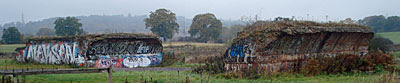
Beyond the A41, so long as you cross carefully, it's all fields. Damp autumnal grassland, uncultivated and meadowed, where thin fingers of the Edgwarebury Brook drain down. One small corner beyond the river has become Edgwarebury Park, while the remainder (as far as the M25, on a distant ridge) is an extensive nature reserve specked with scabious and sedge. Car boot sales are held here on Sundays, big ones, although the season's over now and the tyre tracks are gone. And amidst the grassland, between the hatchback sales pitches, there's an intermittent line of dilapidated brickwork. Welcome to Brockley Hill station.
Five brick piers are all that's left of the low viaduct which should have carried Northern line trains north to Bushey. Of these only one still has sufficient curvature to confirm that these were once arches - the rest have long since crumbled away [photo]. Each stumpy pillar is about ten foot off the ground, I'd guess, each colonised by vegatation, each standing alone in a very deliberate line. One's a flattened U-shape, so it's possible to can scramble up the pile of earth on the inside, then clamber up onto the top of the stonework for an aligned view. And they've all been graffitied, because Barnet's artists love an unsecured canvas, bringing a splash of colour to these islands of brown in a sea of green. [photo]
Check on an Ordnance Survey map to see a faint cutting running north alongside the dual carriageway, heading for Elstree South where there isn't a station either. Next up was London Transport's Aldenham works, which used to repair buses but is now a large industrial park, and finally Bushey Heath which is merely a roundabout. It would all have looked so very different, almost wall-to-wall urban sprawl, had the Northern line reached out this far. But instead Elstree still feels like a village, and the Edgwarebury Brook still runs through open fields, and residents in the new Barratt housing by the Brockley Hill roundabout have to walk ten minutes up the hill to Stanmore station instead. The tentacles of the London Underground, they only stretch so far, and some corners of London are best left well alone. (If you haven't already seen it, Jay Foreman's video about the Northern Heights extension is detailed and ace)
Tube geek (36)Depth and height How deep, or how high, does the Underground network go? London's surprisingly hilly, but only in places, so some of the answers may surprise you...
Stations closest to sea level: West Ham (1m above); Bermondsey, Canning Town, North Greenwich (2m above); Canary Wharf, Elephant & Castle, Kennington, Lambeth North, Parsons Green (3m above) Stations highest above sea level: Amersham (145m above); Chalfont & Latimer (122m above); High Barnet (111m above); Chesham (110m above); Hampstead (108m above); Highgate (100m above) (all based on typical ground level outside station)
Tubewatch (36)Travel tools It's not too many years ago that, if you wanted to catch the tube, you had to turn up at your local station and hope. And now there's no need to say "Oh it's not running, damn!" so long as you've checked the internet or your smartphone first. But I do wonder if you've noticed all the available travel tools at your disposal to keep an eye on how the trains are running. Here's my tube week compilation.
Live travel news All the latest news is on the map on the TfL website, the one with the coloured delays and suspensions, and you already know about that. Then there are the rainbow boards at stations (which you can widgetise and add to a webpage of your own design, if you so choose). Me, I really like the live travel alert service, which sends me a text message every morning if there's disruption on my commute into work, and another on the way home, ditto. You can pick any route of your choice, and any time for the text messages to be sent, or maybe get the info by email instead. Dead clever. Also dead clever are the live departure boards which show the next trains due at almost any station on the network, even if you're sitting at home or in the office. Sometimes they're much better than the information you'd get from the next train indicator board if you were standing at the station.
Engineering work Every weekend we expect engineering hell (unless it's December, that is, when you'll be glad to hear TfL have cleared the decks almost completely to enhance pre-Christmas shopping trips). Next weekend's engineering works are always visible diagrammatically here, or else you can sign up here to get the same information emailed to you weekly. Click the "future dates" option above the map to see disruption on any of the next 28 days - here's Saturday 3rd December, for example - almost clear! If you really need to know up to three months into the future, there's the planned works calendar - recently revamped into a tabular format which does seem strangely familiar. Or for six months advance warning, this regularly-updated pdf has everything you need.
Normal service Being a "turn up and go" railway, the tube doesn't really do timetables. Except there are timetables, obviously, they're just not terribly widely circulated. Download the timetable for any tube line or any tube station from here (or from the interactive map here). Often they're a bit vague, but sometimes they're unexpectedly specific. You might even spot something perversely unusual, like the fact that Bow Road has two Circle(!) line trains each morning at 0524 and 0543. Who knew?
Tube quiz (36)Intermediate stations How well do you know the tube network? Below are ten pairs of stations, each from a different line. All you have to do is pick the correct station inbetween. Easy? Pick from the dropdown list each time. 1) Wembley Central → → Harlesden 2) Grange Hill → → Fairlop 3) Mansion House → → Monument 4) Upney → → Dagenham Heathway 5) Westbourne Park → → Latimer Road 6) Wembley Park → → Dollis Hill 7) Ruislip Manor → → Rayners Lane 8) Tooting Broadway → → South Wimbledon 9) Boston Manor → → Hounslow East 10) Finsbury Park → → Tottenham Hale Answers are in the comments box, so don't peek until you've had a go at guessing them all.
Time once again for diamond geezer to go totally tubular with another week devoted to the London Underground. Prepare for five days of quizzes, quirks, commentary and obscure statistics. Eight years ago I looked at the busiest stations and journeys where it was quicker to walk. Seven years ago I investigated tube line colours and the easiest interchanges. Six years ago I discussed overcrowding and precisely where the underground is underground. Five years ago I wrote about accessibility and why people never move down the platform. Four years ago I examined the agonies of Bank/Monument and taking your bike on the tube. Three years ago I spent the entire week wondering why 'next train' indicators are installed by cretins. Two years ago I visited the tube's least used station and wondered where all the litter bins went. And last year I took the Chesham shuttle and bemoaned the evils of the new King's Cross passageways. I hope there's still something left to write about this year. Mind the doors.

And so ends diamond geezer's ninth annual tube week. I continue to be amazed by how much interactive interest the London Underground inspires, even amongst people who rarely or never use it, so thanks for all your 200+ comments. And I'm also surprised, every year, that I don't run out of new tube-related stuff to write about. I mean, nine years and I still haven't written a tube week post about closed-down stations. Maybe next year...
Tube geek (40) Just a minute
Tube quiz (40)
Tubewatch (40) OSI
Tube quiz (39) Tube fiction
So contractors removed all the next train indicators from the middle of every platform at Mile End, and relocated them instead at the far western end. You can't bump your head on a metal sign if it's at the end of the platform, that was their rationale. Trouble is, you can't see it easily either, especially not from 130 metres away at the far eastern end of the station. And then the planners made things worse by installing four new platform signs, at the bottom of the stairs, one a few yards in front of every NTI. Even fortunate souls with keen eyesight didn't have a hope of reading where the next Central line train was going, because a sign telling them this was "Central line westbound platform 1" now blocked the view. Important real time information hidden by simple static information, that was the problem. Installed by cretins.
Enter HM Inspector of Railways, who turned up at Mile End earlier this year to carry out a risk assessment of his own. He was particularly interested in the information displays mounted on the west end walls and concluded that the display on the westbound Central Line platform effectively invited passengers "to put themselves in a position of danger". While they were trying to stare long distance down the platform, a train could whoosh up from behind unseen and knock them down. That was his expert opinion, so station staff were forced to take urgent immediate action... removing the blocking sign on platform 1! I rarely cheer for health and safety, but it's only thanks to the inspector's visit that the next train indicator is visible again. Admittedly you still need the eyes of a hawk to read it, but that's better than the continuing obstruction on platforms 2, 3 and 4 where no similar decapitation risk was perceived.
• I was travelling home on the Metropolitan line last night, on one of the new S Stock trains, when my train stopped at King's Cross St Pancras. What a lovely step-free gap between train and platform, I thought, unlike the big drop down from the old A Stock trains. I was sitting opposite the wheelchair space, which made me recognise how impressively accessible these new trains are. But then I looked up at the Metropolitan line diagram above the carriage windows - the purple line with coloured circles to show all the step-free stations. Eight white circles (for step-free access from street to platform) and no blue circles (for step-free access from street to train). Hang on, I thought. There's step-free access from street to platform, and these new trains have step-free access from platform to train, so surely there must be step-free access from street to train. So why does King's Cross have a white circle on the S Stock line diagram when surely it should have a blue circle? Any wheelchair user on board the train might look at the wrongly-coloured map and assume it was impossible to get off, which it clearly isn't. Why, I mused, have TfL gone to all the expense of fitting updated line diagrams in these new accessible trains, only for them to include blatantly incorrect information. And then I remembered that the rollout of wheelchair accessibility symbols on tube maps is already a wholly illogical inconsistent shambles, so this stupidity was nothing unexpected, and went back to reading my newspaper.
There were plans in the mid-1930s, big plans, to extend the Northern line beyond the suburbs. The railway had already been responsible for the urbanisation of large areas of Middlesex beyond Golders Green, and now the plan was to repeat this beyond Edgware. Three more stations, one at Brockley Hill, one at Elstree South and one at Bushey Heath, each with vast tracts of undeveloped countryside alongside ready to be covered with housing stock. A few preparatory works were completed, but then World War Two started and all efforts transferred to finishing the High Barnet branch instead. After 1945 London's priorities were different, and legislation to enforce an encircling Green Belt stopped work in its tracks. It was pointless to build a new railway if there were no houses to serve and no passengers to carry, so the extension was cancelled and the line still halts at Edgware.
Five brick piers are all that's left of the low viaduct which should have carried Northern line trains north to Bushey. Of these only one still has sufficient curvature to confirm that these were once arches - the rest have long since crumbled away [photo]. Each stumpy pillar is about ten foot off the ground, I'd guess, each colonised by vegatation, each standing alone in a very deliberate line. One's a flattened U-shape, so it's possible to can scramble up the pile of earth on the inside, then clamber up onto the top of the stonework for an aligned view. And they've all been graffitied, because Barnet's artists love an unsecured canvas, bringing a splash of colour to these islands of brown in a sea of green. [photo]