Today I'm completing my walk tracing the disused railway between Bow and Victoria Park (1850-1944). If yesterday was mostly flats, today is mostly dual carriageway.
Just to the north of Old Ford station, somewhat unexpectedly, the trackbed of the disused North London Railway can still be seen. Step out onto the footbridge at the end of Old Ford Road and there it is, an overgrown strip of green running immediately alongside the A12, plain as day.
A quick bit of local infrastructure history. The A12 is part of the East Cross Route, one of the few sections of the GLC's proposed London Motorway Box to be bulldozed through to completion. It was planned in the 1960s, by which time the North London Railway was only being used for freight, so it made sense to build the new road alongside an existing breach in the townscape. Between 1973 and 1984 an ever-decreasing number of trains ran alongside what was then an urban motorway, the A102(M), before the tracks were finally lifted leaving a thin strip of land unsuitable for development. If only the railway had closed before the road opened a much more efficient use of land could have been achieved, but chronology dictated otherwise. [1893 map][1949 map]
The flats alongside the line are part of the Locton Estate, another Tower Hamlets neighbourhood laid out before the railway closed, otherwise they could have fitted in a couple of extra blocks. The flats on Candy Street are additionally constrained to the north due to the intervention of Joseph Bazalgette's Northern Outfall Sewer. By coincidence this is also the point where his High Level and Middle Level Sewers converge, rising to the surface beyond Victoria Park to continue their journey to Abbey Mills above ground. Thames Water still maintain a depot here to keep an eye.
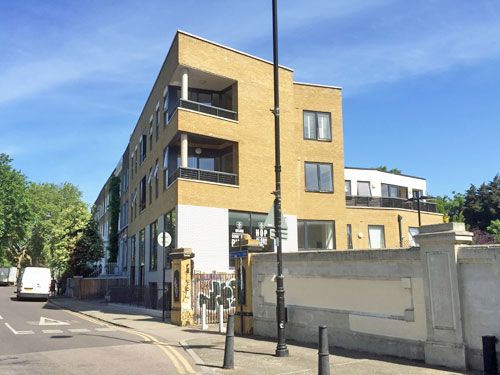
The former railway has become a stripe of woodland by the time it reaches Wick Lane. Here the abutment of the original bridge lingers on as a graffitied brick wall, easily spotted alongside the letterbox tunnel beneath the A12. Ducketts Apartments across the street are the only housing to have been built on the railway alignment north of Old Ford. Another brick abutment marks the point where trains once crossed the Hertford Canal, not many feet above the towpath, and has again proved irresistible to purveyors of aerosol art.
This brings us to the unlikely tale of Britain's first railway murder, which occurred on this very line in July 1864. City banker Thomas Briggs was heading home on a late train from Fenchurch Street to Hackney Wick when he was robbed and beaten for his gold watch, then thrown from the compartment. His body was spotted on the tracks by the driver of the next southbound train and taken to the nearby Mitford Castle pub where he died from his wounds. A German tailor called Franz Müller was accused of the crime after selling the watch chain to a jeweller, subsequently arrested in New York and sentenced to death by hanging. The incident captivated the nation and led to the introduction of communication cords in all train carriages. In 2011 Kate Colquhoun wrote a finebook about the case called Mr Briggs' Hat, which I have attempted not to over-spoiler.
A few years ago you could have popped into the Mitford Castle for a pint, although by this time it had lost its upper storeys and been renamed the Top O' The Morning. Alas the pub closed in 2013, and in 2015 was demolished to make for way a jarring stack of luxury apartments and a new pub called The Italian Job. This being borderline Hackney the new place majors in craft beer and 'insane sourdough pizza', while the noticeboard outside informs us that lockdown tragically aborted a Mothers Day cupcake-baking class. At least they've reaffixed the heritage plaque outside, but its murderous legend doesn't fit the incorrigible hipster vibe.
Cadogan Terrace, you may remember, is inner London's only single track road with passing places. Its Georgian terraces face Victoria Park and no longer have a railway chugging along the rear, so residents must be doubly pleased. The run of houses broke only for Wallis Road, here reduced to a stubby cul-de-sac after the A12 barged brutally through. At its lowest point a thickly wooded embankment is the sole clue that trains were once carried overhead. For pedestrians or those on two wheels a dramatic footbridge extends further across six lanes of traffic as the East Cross Route splits to meet the Hackney Wick interchange.
The junction's complex because it was supposed to link to the North Cross Route but that was never built, for which residents of Camden, Highbury and Dalston remain eternally grateful. It was also complicated by the presence of the North London Railway, which swept across the left-hand carriageways at what used to be ground level via a brand new concrete viaduct. This touched down on the wooded embankment you can see in the middle of the photo, which was also the site of Victoria Park station, by this time defunct. The viaduct was finally removed in the late 1990s, having carried no passengers and very little freight.
The entrance to Victoria Park station was on the bend in Cadogan Terrace opposite what used to be the park's Station Gate. Today it's a car parking space, immediately behind which the A12 carves by in cutting, summarily demolishing all trace of the main building and two platforms. The brick footings of a former signal box survive on the far side of the chasm above the Hackney on-ramp. A third platform existed to the rear, this time on the Stratford line, because we have finally reached what used to be the junction with what's now the Overground. Don't bother looking out of the window on your next journey between Homerton and Hackney Wick because you won't see it because it isn't there. A12 one, North London Railway nil.
Today (and tomorrow) I intend to follow the route of the nearest disused railway to my home, which I have somehow never got round to blogging before.
The line in question was opened by the East & West India Docks & Birmingham Junction Railway in 1850, and was once important, but declining patronage and bomb damage saw it close to passengers in 1944 and to freight in 1984. The trackbed to the south of Bow was reused as part of the DLR in 1987, but the northern tracks were subsequently lifted and have mostly been covered by housing. It's that defunct northern section I'm attempting to trace, aided by the fortunate coincidence that the entire mile falls within my quarantine box.
The North London Line didn't originally go to Stratford but to Poplar, because that's where the docks were. The first westbound trains headed for Islington and Camden, but in 1865 a viaduct was opened connecting Dalston to a new terminus at Broad Street and services were diverted there instead. From Poplar to the City typically took three quarters of an hour, thanks to the inefficiently roundabout route, with trains running every 15 minutes at peak times. You can read a (very) full history of the line on the excellent Disused Stations website, or perhaps join the North London Railway Historical Society to get your four-monthly newsletter fix.
I'm going to start my journey at Bow station, or as it's now known Bow Church. The original station building was on the northern side of Bow Road, with a lofty chapel-like roof and ten arched windows along its frontage, whereas the DLR station was added on a fresh site to the south. Down below were four platforms, the extra two feeding spurs long since built over which allowed southbound trains to head towards Fenchurch Street or Plaistow [1897 map][1955 map]. The bomb-damaged building was retained as a parcel depot after closure but removed entirely when the DLR was built, and today a lowly car hire lot covers the spot. Bow station should not be confused with Bow Road, the disused Great Eastern Railway station 100 yards down the road (1876-1949), nor Bow Road, the later Underground station (still operational).
Just beyond the former platforms the two remaining tracks now narrow to one so that DLR services can rise steeply to curve round towards Stratford. But originally the line ran straight ahead with no connection to the Great Eastern Mainline, amid a veritable granny knot of railways dividing up the heart of Bow. I'd like to show you the modern view from the front of the DLR but that would involve non-essential travel, so here's someone else's front-seat video instead.
To see where the line went next requires a five minute walk down to the police station then back up into the Malmesbury Estate. Trains ran along the back of Caxton Grove, whose terraces have long since been replaced by flats or, on the railway side, a scrap of recreation ground. This is the Four Seasons Green Play Area, a breakout space for local families, thus alas locked at present to avoid unnecessary congregation. In normal times I would have entered the 'Dog Agility Area' at the rear and looked over the fence towards the site of an old signal box, but this too is currently an illegitimate option.
Continuing north immediately requires crossing another railway, this time the mainline into Liverpool Street. The chunk of Bow beyond has been comprehensively redeveloped since the war, one of the most recent additions being a slanting brick block on the former railway alignment in Morville Road. Those giant bluebells are part of an oversized community art project round here - we'll be passing two huge anemones and a massive daisy later. Earlier cul-de-sacs covering the ex-railway have Thatcher Era stamped all over them, with a parking space for all. Having walked up Primrose Close and back for no readily apparent reason, I can confirm that the disapproving Neighbourhood Watch vibes are strong.
At Tredegar Road comes one of the few obvious relics of the old railway, a humped bridge. Cars and buses still slow to rumble over it, despite the fact no train's been underneath since 1984 and housing either side ensures none ever will again. Both Victorian parapets survive, in grubby brick, one now with a communal bin store stashed behind.
The next wall of flats is a 21st century bastion, marketed as The Heart of Bow, and then we hit the Lefevre estate, formerly Lefevre Road, Lefevre Grove and Lefevre Terrace. Its blocks are each named after a Roman god or goddess, individually illustrated in cartoon form above the main door, which must have seemed like a good idea at the time. The estate's centrepiece is a linear park brightened by those hugeanemones I mentioned earlier, whereas railway-hunters need to slip down one of the forbidding cul-de-sacs to discover the former alignment. Chariot Close, between Juno House and Saturn House, is a direct hit on the up platform of our next station.
This is the same estate viewed from the A12, shielded by a barrier block with fearsomely small windows to muffle the roar of the former motorway. The down platform was at its northern tip. Here we find Old Ford station, an 1867 addition to the line which unsurprisingly faced Old Ford Road. This ridiculously long street once ran from York Hall in Bethnal Green to the McDonald's drive-through at the Bow Roundabout, but construction of the A12 severed it in the low 600s, precisely here.
Old Ford station's L-shaped building had a central arched doorway between three pairs of matching windows, and the words North London Railway written in cement across the facade. Also closed in 1944 the building lingered on until 1967 before being demolished, although the RailwayTavern across the road survives intact. Looking at the mundane flats covering the station entrance today, it's hard to imagine earlier residents stopping to buy a newspaper from the W.H.Smith bookstall in the ticket hall before starting their commute into the City.