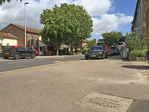
138 miles north of Newham the Greenwich Meridian finally hits the coast in the Lincolnshire town of Cleethorpes. [map][6 photos]
Marine Embankment, Cleethorpes [53.542°N 0°W]
A strip of stainless steel across the coast path marks the spot. It'd be a fairly anonymous spot otherwise, a mile from the buzz of the town's pier and promenade, facing the mouth of the Humber Estuary across the dunes. But Cleethorpes' borough surveyor had the sense to mark the meridian's crossing in 1933 and today a cluster of commemorative clutter has joined it.
The line cuts diagonally across the path, as you'd expect on a northeast-facing coast. It was provided by a Sheffield foundry with a view to proving that their metal plates could withstand maritime corrosion (and has passed that test with flying colours).
At one end is a signpost pointing towards several far-flung destinations including London, Moscow, New York and Sydney. The North Pole is 2517 miles away and the South Pole 9919 miles distant, which places Cleethorpes 20% of the way down this particular line of longitude. Inexplicably the only other item on the precise alignment is a hulking black bin labelled 'Litter' and 'Dog Waste', and I hate to think what the symbolism of this might be.
The other significant marker here is a two ton granite globe funded by the Cleethorpes Renaissance Town Team. It's only five years old but much of Europe and Africa have already rubbed off its surface so I couldn't tell if the meridian had been marked in a special way. Inscribed on the plinth underneath is the legend 'The World revolves around Cleethorpes' which is an admirably proud civic statement if scientifically untrue. The plinth originally supported a sundial, which means this location has featured at one time or another a metal strip, a signpost, a sundial and a globe - the full gamut of meridian markers.
Three benches face out to sea, or more strictly river. The Humber is still a couple of miles from entering the North Sea, the East Yorkshire shoreline low and very distant, with the occasional ship or tanker passing inbetween. Two garrisonedplatforms can be seen amid the muddy waters, Haile Sand Fort and Bull Sand Fort, built to guard the mouth of the estuary during World War 1. SpurnHead is out there somewhere, but being very flat your best chance of seeing it is to spot the lighthouse at its tip. Turning up on the back edge of a storm is not recommended, the view reduced to a thin grey line between the dunes and a leaden grey sky... plus the benches tend to be very wet.
The coast path is half walkway half cycleway, and breaks here for a brief red paved interlude. On the Cleethorpes side it heads past the back of a caravan park and five glum rows of garage-sized beach huts. Almost all were locked shut as I walked by, the sound of a whistling kettle emerging from the odd one out as a husband raised his binoculars towards birds wheeling above the salt marsh. Downriver the path soon reaches the Meridian Car Park at the end of Meridian Road and then an extensive (non-meridian) caravan park. Beyond that are the Humberston Fitties, a 1920s plotlands development of 320 chalets whose leases prohibit residency during the stormy months of January and February.
A narrow gauge track carrying the Cleethorpes Coast Light Railway runs immediately south of the meridian cluster. The railway has been sequentially extended along the coast over the last seventy years, the most recent addition taking it into the adjacent hemisphere, and now runs for a full mile and a half. The closest station to the meridian line is the terminus at Humberston North Bay Lane, its signal box plainly visible to the east. The other stations are Kingsway and Lakeside Central, the latter boasting a signal box which doubles up as 'The Smallest Pub On The Planet' (spoiler: the Guinness Book of Records disagrees). A whistle informed me that trains were indeed running despite the inclement weather, but the service which chuffed slowly past was carrying more staff than passengers.
Just beyond the railway are the ruins of the Pleasure Island Theme Park, which alas became economically unviable in 2016 and awaits redevelopment. The Meridian Showground nextdoor isn't having a good 2020 but one of the Meridian Point Craft Units is open for trading should anybody turn up. Venture further towards the boating lake and you'll discover a small zoo, a Chinese restaurant, a dour flat-roofed-pub, a taproom and a multiscreen cinema in what feels very much like Cleethorpes out-of-town leisure destination. But a steel strip across a footpath was enough for me, not quite the Greenwich Meridian's final landing point but a longitudinal link to back home all the same.
To complete my journey along the Greenwich Meridian through Tower Hamlets and Newham, today I'm covering the section north from Stratford station. It could be worse, I could be blogging all the way to Cleethorpes. [map][photos]
Stratford station [51.543°N 0°W]
Stratford station may resemble a sprawling octopus with platforms firing off at all angles, but only one of them crosses the meridian. Crossrail's future platforms miss by some distance. Platforms 9 and 10 serving long distance Greater Anglia services almost reach. But the occasionally-served platform 10a extends a fair bit further to the east, so anyone walking 40m beyond the last shelter could find themselves waiting for a train on the zero degree line.
To take a decent photograph of the far end of the platform I made my way to the unnamed service road that lurks behind Stratford One, the Unite Students accommodation fortress, and ignored all the notices suggesting the public aren't terribly welcome back here.
MSG Sphere [51.544°N 0°W]
A large chunk of land remains undeveloped behind Stratford station on a triangular site bounded by platform 10a, platform 11 and the High Speed 1 trench. What's planned to erupt here is the MSG Sphere, a huge globular music'n'entertainment venue more capacious than the Manchester Arena, optimally located alongside the perfect transport hub. It'd also sit astride the meridian, which is a boast the O2 down in Greenwich can't quite match. But this 92m tall golfball will also have "a fully-programmable exterior that serves as a digital showcase for the venue, artists and partners", which basically gifts central Stratford an unavoidable advertising screen contaminating the night sky. Planning permission is pending but not yet granted. Whether investors deem the place profitable in a new normal future is yet to be seen.
Eurostar trains cross the meridian here, just before entering/after exiting the tunnel between Stratford International and Dagenham.
New Garden Quarter [51.545°N 0°W]
It sounds like Telford Homes spun their Residential Development Buzzword Generator when they named New Garden Quarter. Obviously it's new. Yes there is a central garden. No it's not a quarter, just a dense horseshoe of flats built across brownfield land round the back of Westfield. The sales brochure describes it as "a contemporary interpretation of a classic London Square" but although the intention was Grosvenor Square what the architects delivered was a bland white-faced fortress with a jumped-up children's playground in the middle. The meridian runs past the automatic bollards on the central access road, immaculately paved but with the whiff of bins.
To prove it's not all regeneration round here, a tiny light industrial estate survives across Penny Brookes Street. They'll repair your vehicle, they'll tint your window, they'll polish your nails, but best of all they'll fire you up jerk chicken if you're Jamaican Me Hungry.
Warren Gardens [51.548°N 0°W]
This is random. Warren Gardens is the very definition of an insignificant street, a dozen lowly flat-roofed postwar houses on a gently curving dead-end terrace. One resident has built a play castle in their tiny front garden, complete with battlements, while most have left theirs lightly weeded. But among the paving slabs out front is one with a Greenwich Meridian marker, partly because the zero degree line passes through number 3 and partly because someone at Newham council inexplicably decided Warren Gardens deserved one of the borough's trio of commemorative markers. Abbey Lane and Stratford High Street I get, but this is fantastically niche. Alas the paving slabs have been relaid at some point and someone accidentally rotated the meridian marker through 90° so it now points east/west and is essentially invalid.
We now enter a grid of Victorian terraced streets so the opportunities for meridian marking dry up somewhat. I did find a mysterious circular footprint on the correct alignment in Chandos Road Open Space, but I suspect it's just the remnants of a dead bench or similar.
Crownfield Road [51.552°N 0°W]
Here's one last slab in the pavement. It's on the south side of the Crownfield Road during a brief run of unterraced houses outside number 153. It's got a crack across it, thankfully not along the central line, but then it is thirty-six years old. You may notice there isn't an 'N' in the middle, and that's because we're not (quite) in Newham any more - Crownfield Road is the first street in Waltham Forest. Sixty meridian-crossed streets in Waltham Forest were marked with green thermoplasticcompasses for the millennium, but this gets a bit samey after you've seen a few, plus most of them are now looking very much the worse for wear. I did check out the first in neighbouring Drapers Road just so you get the idea, but best stop there.
• Today's 8 photos can be found here
• The entire set of 40 photos can be found here
• Further meridian markers are listed here and here
Having passed out of Tower Hamlets yesterday, today I'm continuing my walk along the Greenwich Meridian through Newham. Bear with me, we will eventually reach somewhere you actually recognise. [map][photos]
Greenway [51.532°N 0°W]
The Northern Outfall Sewer passes just north of Abbey Mills Pumping Station, above ground on a brick viaduct, with the Greenway permissive footpath running along the top. In 2004 a rather charming meridian marker was embedded in the tarmac, an analemmaticsundial. Stand in the right place, which varies month by month (for reasons previously explained), and your shadow will point towards the correct time. If the brass numerals around the edge look quirky that's because they were designed by children at Manor Primary School in collaboration with artist Kate Williams. Only if you wander over to read a small plaque on a nearby pillar is it mentioned that the noon line aligns perfectly with the Greenwich Meridian, and I wonder how many of those walking or cycling by have ever realised the full significance.
By coincidence this is also the point where Abbey Lane passes underneath the mighty sewer pipes. I'm reliably informed there's another meridian marker down here, a slab set in the ground, but although I've been back twice I cannot find it. I suspect it's either been removed or has been obscured by rampant vegetation... I need to come back in winter and check.
Rick Roberts Way [51.533°N 0°W]
This is a dull backroad, essentially a ratrun through a light industrial estate, and meridianly unmarked. I mention it partly because the building to the north (now vacant) is St Clements Press where The Guardian used to be printed when it was awkwardly shaped. Meanwhile across the road is the Mercedes Benz service centre which moved from the site ofthe Olympic Stadium, and whose car park now features several weary notices saying no, this is not the entrance to the Covid-19 test centre.
Channelsea Path [51.535°N 0°W]
The ChannelseaRiver once threaded north from Three Mills through almost-the-heart of Stratford, but wasn't compatible with a growing suburb so was covered over. Between the Greenway and Stratford High Street they turned it into a footpath, a meandering stripe of tarmac lined by bogstandard vegetation and with a minimal number of access points. Walking along it requires passing out of human sight for several minutes, and within shouting distance only of the back of the Jubilee line depot, so can be somewhat unnerving. The Greenwich Meridian deigns to cross at the northern end where a concrete block topped with insectlike art has been plonked in the middle of the path. The 'Channelsea Gateway' was created by the same team that installed the Greenway sundial, which makes me think its location is deliberate, but this time the accompanying plaque stays silent on the matter.
The meridian scores a direct hit on Buzz Bingo, formerly Gala Bingo, on Stratford High Street. Perhaps they could introduce a zero ball to celebrate the fact.
Stratford High Street [51.539°N 0°W]
Hurrah, an actual proper meridian marker set into the pavement. This one is located on the north side of the High Street on the bridge above the Jubilee line, specifically the southbound Jubilee line if you want to be really accurate. The slab's been slanted so that the line across the middle follows the correct alignment, and in the centre is Newham's appealingly spiky 1970s logo. Coincidentally this is a letter 'N' which adds reinforcement that the line points north, which indeed it duly does. I understand there are three such plaques across the borough, one in Abbey Lane (that I couldn't find), one here and another further north (that we'll get to tomorrow).
Meridian Square, Stratford [51.542°N 0°W]
Bullseye! An arbitrary line drawn due north from a telescope in Greenwich just happens to pass through one of London's most important transport interchanges. It lines up perfectly with the revamped pedestrian crossing at the southern end of the Stratford Bus Station. It grazes the passenger-free corner of the bus station behind the mess room and staff toilets. It crosses Great Eastern Road on the slant. It passes through newly-introduced Bus Stop P. It ducks beneath the shiny scales of The Shoal. It then runs pretty much perfectly along the row of doors at the entrance to the Stratford Centre (or possibly a few feet further back through Burger King and Subway). Purely by coincidence this shopping mall portal has become a dividing line between hemispheres... outside west, inside east.
But this is not what the nearest meridian marker says. Inexplicably a geographically incorrect line runs across the main piazza, bold as brass, on the wrong side of the supersized pedestrian crossing. Embedded alongside is a ribbed metal rectangle reading Meridian Line 0°0'0"E when in fact this is 0°0'2"W. If the meridian truly ran along this alignment it'd make sense of the piazza being called Meridian Square, as it has been since the millennium when Stratford station was upgraded. But Newham's planners appear to have made a lazy assumption, then compounded it in 2010 when the brass line was added as part of an upgrade to prepare for Westfield crowds. Thirty metres, it turns out, makes all the difference.
The meridian was previously marked by a twirly sculpture called Time Spiral, again in not quite the right place, but this was removed to Maryland ten years ago (and lost its clock faces to boot). The name 'Meridian Square' appears to have been lost more recently. It was officially used on the street signs at the entrance to the taxi drop-off serving Stratford station, but the remodelling of the bus station shifted taxis elsewhere so this particular loop of road has been sealed off. As of last month it lies behind a shield of whitewashed hoardings and will probably never see traffic again. If you'd like to complain about this action you have until Wednesday next week to apply to the High Court for a suspension order.
Bluntly, the marking of the meridian through Stratford is a mess. It is marked where it doesn't exist and it isn't marked where it does. There again, the modern GPS meridian actually runs through the 4-way atrium at the centre of the Stratford Centre, 100m to the east, so you could wonder why anyone is bothering at all.
The meridian passes through the 23-storey Unex Tower on its way into Meridian Square and through the 33-storey Legacy Tower on its way out, so I suspect that's the Greenwich Meridian laser scuppered.
• Today's 12 photos can be found here
• Tomorrow we continue from Stratford station
Today I'm continuing my walk along the Greenwich Meridian through Tower Hamlets and Newham... or attempting to walk along it because direct passage becomes a lot harder from here thanks to a derelict gasworks, a tidal river and several industrial estates. So, plenty to look forward to... [map][photos]
New Village Avenue [51.513°N 0°W]
Much of the postwar Aberfeldy estate, cut off behind the A12 and the A13, has succumbed to regeneration over the last decade. Most of the housing association flats bordering the East India Dock Road have been knocked down and replaced by something sparklier, blockier and more likely to have a 24 hour concierge. Initially the marketing team called it Aberfeldy Village but they've since morphed to calling the site Oxbow, which is a godawful name because a) it's not in Oxford b) it's not in Bow and c) it does not in any way resemble a disconnected meander. The main thoroughfare retains the name New Village Avenue, however, although there's nothing rural about a long grassy canyon with occasional footbridges crossing an imaginary water feature. About the only thing I like about the development is that they remembered the Greenwich Meridian exists and marked it with a lovely brass spike across one of the walkways.
The meridian passes through Watermans House, Traders House and Blairgowrie Court. None of these are as vibrant as the marketing collateral claims.
Abbott Road [51.514°N 0°W]
Nudging up against all this redevelopment malarkey, Abbott Road is a throwback to when these South Bromley streets were the closest to the docks. Only a few Victorian buildings survive, but the majority of residents are still lucky enough to have proper houses rather than flats. The meridian cuts invisibly across the point of a triangular parklet past a road sign using not quite the right typeface pointing not quite the right way.
Poplar Gas Works [51.516°N 0°W]
In the 1820s the Poplar Gas Company opened its first gasworks alongside a bend in Bow Creek. It did its dirty job for decades, out of general sight, and grew to accommodate threegasholders, two retort houses and numerous tanks and gantries. In 2010, its job done, British Gas announced plans to demolish the lot and remediate the 20 acre site. 28,000m³ of mucky spoil was removed, much of it by barge, and today the land is securely fenced awaiting, you guessed it, 2800 flats. Tower Hamlets nodded through planning permission earlier in lockdown, with full completion scheduled to take many years. One major benefit will be the opening up of 500m of riverside path, but on the downside the developers have only been asked to leave space for footbridges across the Lea rather than funding any themselves, leaving future residents potentially rather cut off.
The Greenwich Meridian cuts across the heart of the site, as you can see on this artist's impression culled from the masterplan. Unfortunately I've had to add the red line myself as the architects appear to have completely overlooked the meridian's existence. It doesn't get a mention anywhere in their 24 page Design Evolution document, and the footprint of the blocks and towers entirely disregards the alignment. There are always other factors to be taken into consideration, of course, but it does seem a terrible waste of geographical good fortune given that branding a location 'Meridian Something' invariably adds value.
A footbridge across to Cody Dock was granted planning permission in 2010 but has never been built, as if this section of the Lea Valley Walk is forever cursed.
Bow Creek [51.518°N 0°W]
The River Lea is broad and tidal at this point, and also entirely inaccessible to the public. The meridian crosses the river just downstream of Cody Dock, tantalisingly out of reach, and enters the London borough of Newham through the depot of GBN Services Ltd, specialists in skip hire, recycling and waste transfer. To stand on the zero degree line you need to head for the stretch of South Crescent immediately outside the arched entrance to Cody Dock, close to a cluster of parked-up street sweepers, and deftly dodge any passing trucks.
Cody Dock itself is lovely, an evolving community asset to be proud of, but alas it misses the meridian by about twenty metres.
Cody Road [51.521°N 0°W]
The Cody Road Trading Estate houses numerous businesses London needs but nobody wants to live near. As such the location is ideal because absolutely nobody does. High fences and locked gates screen off cement works, electricity substations, builders yards, document archives, car rental depots, windscreen repairers, food wholesalers, even a dealer in eels. If the wind's in the right direction you might also get the whiff of freshly-roasted coffee but that's a rare treat. The meridian crosses Cody Road in the tiny gap between North Crescent and South Crescent where the pavements are generally clogged by unmarked delivery vans and off-duty ambulances. May you never have any good reason to visit.
For the next 700 metres there is no public access to the meridian, other than those aboard trains between West Ham and Bromley-by-Bow stations. The easternmost of the Twelvetrees gasholder cluster is narrowly scraped.
Long Wall Path [51.528°N 0°W]
Here's one of my favourite local paths, a secluded dogleg clinging to the north bank of Abbey Creek. It was closed for ten years while Thames Water completed adjacent works on the Lee Tunnel but reopened in 2016 connecting Three Mills to the Greenway. The waterfront is mostly obscured by undergrowth and mud while inland is screened by a security fence, so it can feel a bit like you're walking through a green tunnel. I used GPS on my phone to try to work out where the meridian passes, and I think it's the one spot where the undergrowth has been trodden down and the fence has been yanked open, but ultimately there is no escape.
The field in which the first two series of Big Brother took place is (almost) just behind the fence (but marginally into the western hemisphere).
Abbey Mills Pumping Station [51.531°N 0°W]
Not only is this an absolutely glorious building but the Greenwich Meridian slices through the cruciform engine room. Abbey Mills Pumping Station was built by Joseph Bazalgette as part of his 1860s sewage masterplan and helped flush London's effluent down the Northern Outfall Sewer towards Beckton treatment works. It is ridiculously over-decorated, but Victorians liked to go way over the top in their public works. These days most of the work has been taken over by a separate silvery-roofed pumping station, also coincidentally astride the meridian, but the old girl still adds her weight when required. Should you ever get the opportunity to look inside, as I managed in 2011 with Open House, move mountains.
Apologies, there's only been one proper meridian marker in today's post, right at the beginning. We'll do better tomorrow.
• Today's 10 photos can be found here
• Tomorrow we continue from the Greenway
I thought this might be a good time to walk the Greenwich Meridian. Not all of it but the three miles through Tower Hamlets and Newham because that's easily accessible. This blog loves nothing better than following an invisibleline across a landscape, and the Greenwich Meridian is about as important as an invisible line gets. It's also annoyingly ambiguous as there have been four marginally different meridians at Greenwich over the years, each aligned with a different telescope, while modern GPS systems use a separate line approximately 100m to the east. I'm going to be following the Bradley Meridian because that's what the Ordnance Survey use, plus it's the most likely to have been marked with plaques, brass strips and other markers. We'll be passing at least a dozen of these. [map][photos]
Brunswick Wharf [51.507°N 0°W]
The Greenwich Meridian skims across the Thames and enters North London with a flourish. A large tiledcircle with a compass at its centre marks the spot, cleaved in two by a thin bronze strip stretching across the promenade. Stand by the railings and you can look due south down the edge of the North Greenwich peninsula past a jetty and a driving range towards the observatory on its hilltop, possibly with a boat cutting through the water inbetween. This spot used to be covered by the BrunswickHotel, one of two hostelries built to cater for those travelling though Blackwall by steamer. Initially it was the more upmarket of the two, famed for its whitebait suppers, but by 1900 it was left serving low quality beer to dockers and in 1930 it was demolished.
It's nice here, a quiet corner of the Thames Path with a sweeping river view. A locked gate labelled 'Jubilee line replacement boat services' prohibits further westward progress.
Prime Meridian Walk [51.508°N 0°W]
When the East India Import Dock got filled in they built a power station on it, and when that was demolished Barratt Homes got first dibs. Here they built the Virginia Quay estate, a stepped stack of very-1990s flats, and their architects had the forethought to recognise the passage of the Greenwich Meridian. The entire zero degree line is free of buildings and laid out as an attractive beech-linedavenue. called Prime Meridian Walk. This rises gently from the riverside to cross Newport Avenue, then acts as an alleyway between a playground and the back of a Nisa supermarket. In total it runs for 250 yards which is the longest you can walk along the meridian anywhere in north London... or would be if only someone hadn't positioned a car parking space halfway along.
Sexton Court's back garden fence also aligns with the meridian at one point, so technically it's impossible to walk the precise line here too.
East India station [51.509°N 0°W]
East India is one of a handful of London stations which lie on the Greenwich Meridian. Both of the elevated platforms are crossed, at the far eastern end, the precise alignment apparently once painted across the track as a red line (alas long faded). Conveniently an extension of Prime Meridian Walk continues beneath the viaduct, narrowly missing a large concrete pillar, so passage is a lot easier to see at ground level. Better still the meridian line then heads straight up the front of a 25-storey residential block, the Elektron Tower, whose footprint was deliberately nudged so as not to block the Greenwich Observatory's laser. Vertical meridian markers are rare but here there are two, one on each flank of the tower.
Greenwich Observatory's green laser fires along the Airy meridian where the line up the side of the building follows the Bradley meridian, in case you were wondering how both can be correct.
East India Dock Tunnel [51.510°N 0°W]
The western portal of this short modern underpass (linking Aspen Way to the A13) aligns pretty much perfectly with the meridian, but is not marked.
Telehouse [51.511°N 0°W]
When the East India Export Dock got filled in the London Docklands Development Corporation turned it into an administrative estate. Tower Hamlets built their new town hall at one end and one of London's first data centres opened at the other. The London Internet Exchange (LINX) started out in 1994 as the home of Pipex and today, as Telehouse, is the centre of most of the UK's data networks. The British hub of the main transatlantic fibre cable between Europe and North America lies somewhere inside this campus of chunky windowless buildings, which means it's highly likely today's post passed through Telehouse before it reached your screen. And yes, there is as much security around the perimeter as you'd expect at such a strategically important location.
Telehouse have plans to expand onto the adjacent Travelodge site, which is why the Travelodge is moving to a site by the Aspen Way roundabout, which is why that mysterious red cycleway has suddenly appeared alongside.
East India Dock Road [51.512°N 0°W]
I hadn't spotted either of these plaques before, which just goes to show the power of research. The plaque on the wall is dated 28th February 1991 "and commemorates the widening of the East India Dock Road". The road had been in existence for almost 200 years as a thoroughfare connecting London to south Essex, but needed to become a dual carriageway hereabouts to cope with Blackwall Tunnel and Docklands traffic. The closest plane tree was planted, the plaque tells us, by the Minister of State for Transport, a Tower Hamlets councillor, an LDCC board member and the managing director of Telehouse. The granite rectangle embedded in the pavement may or may not be of a similar vintage, and reads The Greenwich Meridian Line 0° Longitude Established 1884.
A matching granite slab can be found on the same alignment on the opposite side of the road (but without a matching plane tree).
• Today's 10 photos can be found here
• Tomorrow we continue from New Village Avenue