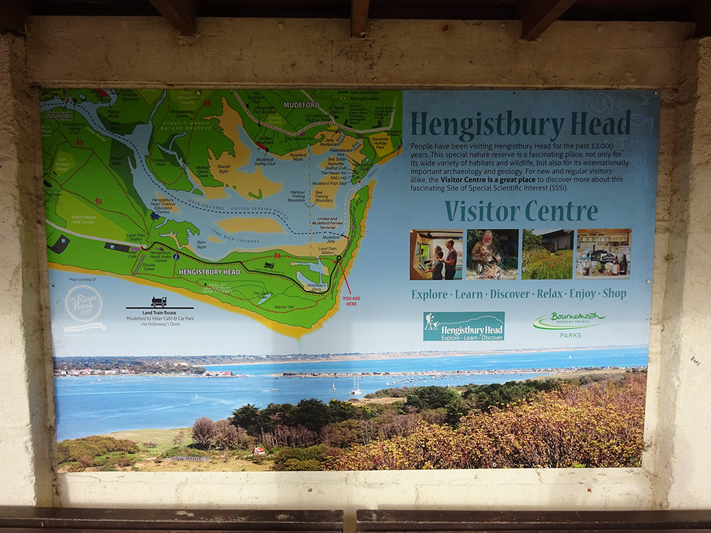
A lot of the south coast is unbroken gently-curving coastline, interrupted only by rivers entering the sea. But some of these interruptions are spectacular, the mouths to natural harbours often part-protected by a hooked headland or sand bar. So it is at Christchurch where the harbour is tucked behind a long sandstone headland - that's Hengistbury Head - and almost sealed by the sandy protrusion of Mudeford Spit. Not only is it a gorgeous seascape it's also possible to walk a complete circuit of the harbour, aided only by a teensy ferry hop from tip to tip. So I did. [Visit Hengistbury Head][40 photos]
The arc of Poole Bay runs ten miles from Sandbanks through Bournemouth to Hengistbury Head with sandy beaches all the way. I started my assault on the headland from Southbourne, easternmost of the coastal suburbs, which is just off the bottom left hand corner of that map. Here a solid grid of bungalows and retirement-focused avenues suddenly breaks into open duneland, the sand underfoot not always the easiest to walk on. It being a bank holiday the beach was packed, thinning slightly as proximity to car parking space decreased, the roasting contingent including dune-sitters, sand-sprawlers and drippy paddlers between the groynes. I stuck slightly inland, following an intermittent boardwalk, and enjoyed the sight and sound of skylarks emerging from the Whitepits and arcing overhead.
This is not the only way in. From the Wick Ferry at Christchurch a mile-long footpath offers a harbour-side shortcut from which the harbour itself is rarely seen. Alternatively you can just drive in past the golf course to a final car park where £6.40 for two hours probably isn't going to be enough. These routes pass a cafe and then a proper Visitor Centre complete with natural history galleries, geological exposition and the inevitable gift shop, or so I assume. By following the track 200m closer to the sea I missed the lot, mainly because it was so hot I didn't fancy adding another ten minutes to my walk. You probably don't want to skip it if you come.
A ditchy rampart called Double Dykes crosses the headland here, a defensive fortification dug in the Iron Age to protect Hengistbury's far end. It's fenced off so you now have to walk around it, additionally because the field contains a 4000 year-old barrow cemetery from the Bronze Age, but that seclusion has done wonders for the wild flowers within. This is also the last point before the headland rears up to a chunky wedge, this part officially called Warren Hill. I could have followed the beach and walked below the cliffs but instead the allure of the rising track was too great, all the better for gaining an overview of the surrounding landscape.
Near the top of the ascent is a skew pillar of yellowish rock strata, this an artwork called Layers of Bournemouth built in situ for a fringe festival in 2018. It's perhaps there to distract from the actual cliff face immediately ahead where encroachment is strictly forbidden. A few steps and a twisty climb later you're at the summit trig point, admittedly only 36m up but with a view the Ordnance Survey would have revelled in. That's Bournemouth in the distance round the curl of Poole Bay, also the sweep of the estuary with Christchurch Priory at its head, barely a mile away but I'd walked much further to get here. Also visible for the first time is the lineof huts on the sand bar at the end of the harbour, still tiny, and yes across the sea that's The Needles on the Isle of Wight. I grinned, but then I always was a sucker for geomorphology and height.
The National Coastwatch have taken advantage too with a small hut, a dishy mast and a telescope trained on the start of the Solent. According to the whiteboard out front there had already been 20 'incidents' this year, the last of these the day before. The path weaves down past a gouged lake that in Victorian times was a quarry for ironstone shipped off to the Welsh collieries, that is until unbridled erosion to the headland (and public opinion) caused works to cease. Poole Bay ends at a final groyne pointing seaward, beach occupancy now minimal, and the path pauses by two overelaborate wooden benches where you can stare out towards the next coastline twiddle at Hurst Point. Turn left for Mudeford Spit.
This is again not the only way in. The walk round the base of the cliffs must be dramatic because, as usual, you don't really get a sense of their fragility and majesty from on top. But there's also a much simpler path on the harbourside of the hill, this time nigh flat and passing through properly ancient woodland. This is where those with pushchairs and picnic baskets go, also the famous Land Train that first shuttled along in April 1968. Locals initially detested the intrusion, even scattering nails across its path to deter the owners, but a six month trial swiftly became a long-term summertime connection and today it's run by the council (single ticket £4.95, card and contactless only).
I can't tell you what Mudeford Spit is normally like because I arrived at what might just have been its annual peak - half past two, bank holiday afternoon, mid-heatwave. The sand bar is a kilometre long and barely 100m wide with a chain of 400-or-so brightly paintedbeach huts all along one side. They're a decent size too, many equipped with solar-powered electricity and an upper mezzanine for potentially sleeping overnight, and I was dead impressed that almost half appeared to be in use despite the relative inaccessibility of the location. Out of these spilled reddened retirees, watersporty types and full family groups, all seemingly normal enough so I was shocked later to discover that these beach huts sell for up to half a million pounds, such is the allure of the barely-attainable seaside.
At the farthest tip are the Black House, a fenced-off enclosure for plovers and a thin bar of sand that tapers to a point. A deep but narrow channel is all that separates Mudeford Spit from Mudeford Quay, this the ultimate outflow from the harbour. To cross would only be a 50m swim, were this not strongly discouraged due to strong tides, whereas on foot it's a six mile walk. Thankfully the Mudeford Ferry exists to shuttle spitgoers and headtrippers back and forth, but departing from a jetty halfway down the spit so crossing feels more like you're getting your £3.50-worth. Two catamarans operate the peak schedule, each with a maximum capacity of 32 but less if someone's carrying a bike, sailboard or trolley. This time it's strictly cash only but cats, dogs and parrots ride for free.
This is again not the only way in. Bournemouth Boating Services run a river cruise from Christchurch Quay to Mudeford Spit, essentially a scenic jaunt through the harbour but also the simplest way to reach the sandy beach hut bonanza from where people actually live. But this time the single fare is £11, a hefty amount that must soon add up if you're out here regularly. Also all the ferries cease ferrying at 5pm precisely, this bad news if you're enjoying a gorgeous sunny afternoon on a farflung coastal feature and plan any kind of evening revelry. Such are the downsides of an expensive tiny property it's impossible to drive to.
The ferry delivers you to Mudeford Quay beside a stack of lobster pots I don't think were only there for tourist purposes. Alongside are a few fishermen's cottages and a heaving pub, also the local lifeboat station, also a quayside rammed with small children lowering lines into the water to catch crabs. This was smuggling central back in the day, as a self-guided Smuggler's Run Trail explains should you choose to follow the multiplicity of boards towards the town. I merely hiked back to Christchurch the easy way along suburban streets, completing my circuit of the harbour and all somehow without overheating. Things may not be precisely the same if you visit as the spit has a long history of breaching, reshaping and regrowth, but this time I was really pleased I'd chosen Christchurch over over-familiar Poole and Bournemouth.