TfL's name includes a strong clue that their job is supposed to be providing transport in London. But their influence stretches across the border of the capital, mainly for historical reasons, with several services running beyond. The Metropolitan line heads out into Herts and Bucks, for example, and the Central line serves a chunk of southwest Essex. Meanwhile as many as sixty London bus routes ply their trade outside the boundaries of Greater London, providing an often invaluable service to residents who don't pay London council tax. To make things fair, local authorities outside London pay a grant to TfL to ensure these peripheral buses continue to run. So what happens when that grant is cut? We're starting to find out.
Last November, Essex County Council voted to end a £586,000 subsidy to TfL which helped pay running costs for bus routes 20 and 167. Both these routes begin well inside London, head for the boundary and then run about five miles into Essex. Route 20 starts in Walthamstow and leaves the capital near Woodford, before continuing through Buckhurst Hill and Loughton to Debden. Route 167 starts in Ilford and leaves the capital near Grange Hill, before continuing through Chigwell, Buckhurst Hill and Loughton to Debden. TfL has no remit to serve these Essex locations, so might the end of council funding see these two buses cease?
A myriad of deregulated bus services run beyond the Greater London boundary, without the need for subsidy to prop them up. This usually means fares cost more, often quite a bit more, as those who live outside the capital know well. And it usually means buses run less frequently, or stop in the early evening, and maybe don't run at all on Sunday. But without that half million pound grant to top them up, why should Loughton and Debden continue to be an anomaly?
Essex's cut in revenue took place in April, but TfL have taken until this month to respond. A consultation has been launched proposing that route 167 be cut back, terminating in Loughton rather than Debden. That'll cut about 20 minutes off the route, and reduce the number of vehicles needed to run the service, so should therefore save a bit of cash. But they're not cutting the service all the way back to the boundary, which means residents of Chigwell and Buckhurst Hill will still be able to catch buses their taxes no longer pay for.
Perhaps more surprising is TfL's proposal to leave route 20 alone. This bus spends about half its time in London and half its time in Essex, but the Essex half is to see no reduction in service whatsoever. And I think that's rather impressive. Indeed if you step back and look at what TfL have actually done, they've noted that the 20 and the 167 run along virtually the same route between Loughton and Debden and withdrawn the less frequent of the two. Nobody along this part of the route loses out, except in frequency, and TfL still rakes in money from fares to help offset the loss of grant.
Residents of the council estates of Debden and the Towie streets of Loughton aren't happy, particularly those who'll now need to catch two buses to make their journey rather than one. But here's where the Mayor's Hopper ticket suddenly makes a difference, because by the time this cut is made it'll continue to be possible to travel from Debden to, say, Chigwell, for the price of one fare rather than two.
And there are still two other TfL buses out here that aren't being affected. The 397 will still run from Chingford to Debden, providing a more direct link to Loughton, although that packs up before eight in the evening. And the 549 will still pootle up the backstreets, ensuring Roding Valley gets some sort of bus service, but this now only runs every 70 minutes and for only six days a week.
It's not yet the case that residents of Loughton and Debden must rely on the whims of private suburban operators. But they do have severalofthese already, including very brief circular buses, buses with A and B suffixes, buses that only run on Sundays, and a bus that runs only once a day. It all makes TfL's "frequent, reliable, simple and comprehensive" network look positively modern.
Meanwhile eyes are turning to the borders with Hertfordshire, whose councillors have made a very similar move. The county used to subsidise five TfL-operated cross-boundary routes at a cost of £390,000 a year, but that money also stopped in April, and local residents are concerned. The affected buses are the 142 and 258 from Watford, the 107 and 292 in Borehamwood, and the 298 from Potters Bar. Each of these has a long section outside Greater London, indeed for the 107 it's most of the middle of the route.
TfL could decide to lop back the buses to the borderline, for example terminating the 142 and 258 at Bushey Heath, although they'd then lose out on a lot of fares to Watford. They could choose to remove some of the faffing around the outer estates that the 292 does on either side of Borehamwood, or perhaps even all of it. They could rejig the local service pattern to provide more efficient coverage inside London and fewer bits outside, whilst still ensuring that key boundary locations like the Royal National Orthopaedic Hospital remain served. Or they could just back out of Hertfordshire altogether, as they have with most of Bucks and Berks, and leave the commercial operators to it.
All that TfL have said at present is "There are no current plans to make alterations to any of our bus services that run to and from Hertfordshire" but also that "If in the future we propose to make any changes, we will undertake full stakeholder and public consultations as we do for any bus service." The Essex experience suggests that a consultation might well be on its way, but it's unlikely to propose the complete withdrawal of routes that manyresidentsfear. Instead I wonder if they'll look at the four miles of double bus route between Bushey Heath and Watford and try the Debden trick again, removing either the 142 or 258 from this stretch. We'll have to wait and see.
In future other neighbouring counties might decide to drop or remove their subsidies, with the number of red bus services crossing into Surrey already looking quite anomalous. Meanwhile TfL still need to respond to a significant cut in central government funding, and to balance the budget now they have a Mayor who refuses to increase fares. The lesson from Loughton appears to be that they're keen to make minimal changes to the bus network, focusing on route efficiency and the protection of community links. But we live in times of financial cutbacks, and outer London in particular can perhaps expect to see more of this kind of thing.
You can see it from the M25. Between junctions 26 and 27, where the orbital skims the edge of Epping Forest, a Palladian mansion is visible across the fields. This is Copped Hall, built in the 1750s on a historic site with links to royalty and Shakespeare, and whose frontage hides the damage wreaked by a great fire within. But a band of volunteers are putting the house and garden to rights, and every so often they open up and invite the general public inside. Top trip. [12 photos]
Where was King Henry VIII while Anne Boleyn was getting her head chopped off? Pacing the yew avenue at Copped Hall listening for confirmation from cannon fire at the Tower, if the story is to be believed. Where was Catholic Princess Mary quarantined during the reign of her brother Edward VI? Copped Hall again, for sure. And where did the very first performance of A Midsummer Night's Dream take place? Many believe it was in the long gallery at Copped Hall, on the occasion of the wedding of the owner Sir Thomas Heneage, one of Queen Elizabeth's favourites. That's a pretty impressive line-up of Tudor hearsay.
By the 18th century the estate had passed to the Conyers family, who demolished the original hall and built a new one, and it's this that motorway drivers espy today. The final owners were the Wythes, who went off to church one Sunday in 1917 expecting a small fire to be put out, and returned to find their house ablaze. The building and estate were left to decay, suffering neglect and vandalism as well as the carving of the M25 through the edge of the estate. Then in 1995 the shell was bought up by the Copped Hall Trust, and their long term goal is to restore the house to its Georgian splendour. With a lot of help from donations and volunteers, against all the odds, they're getting there.
Guided tours of Copped Hall take place on the third Sunday of every month, except December. The front gates open at 10am and close at 11am, so you have a very narrow window to arrive, but the subsequent perambulation takes the best part of three hours, which is damned good value for the £8 fee. First you get an hour and a bit's tour of the house, then a brief refreshment break, and then an hour and a bit's tour of the garden. All three parts are great, and the garden's clearly at its very best in summer.
The restoration of the house is an amazing example of what can be achieved long term by a dedicated group. When they started work there were trees growing inside and unstable chimneys tottering in the wind. Today the building's weatherproof with replacement wooden floors, and all the rooms on the lower levels have been at least part restored. The kitchen in the cellars looks very much like a kitchen, the lady's bedchamber looks good enough to be used in modelling shots, and the high-ceilinged saloon is once again an ideal space for entertainment.
But it's an expensive project. Every replacement window costs in the order of £2000, and the same for the flagstones of the cantilever staircase now being reinstalled, while the expert plasterwork is thanks to a participant on a previous tour who said "oh I could help you with that" and now does the lot.
Our guide on Sunday was excellent, and led us through the rooms with a mix of knowledge and good humour. We had to rush through a few on the ground floor because they were being used by a local Shakespearean company preparing to deliver some outdoor theatricals, just one of the many events that take place in this splendid setting. If you fancy some jazz, or a lecture, or a wildlife photography course (the latter heavily oversubscribed), Copped Hall has something for you.
They also do a lot of educational work - it's easier to get grants that way - and some of the rooms in the north wing are given over to a fascinating series of exhibition panels. We could have lingered longer there, indeed probably in every room, but that three hour deadline was ticking away. Goodness knows how they'll fit everything in when the second floor is opened up, rather than being accessible only via a couple of rickety ladders.
The tea was nice, and the cakes were excellent. Sometimes at these places you get pre-packaged muffins or limp sponge, but this spread was diverse, lush and home-baked (including two gluten-free options). Refreshments are served in the Racquets Court, a precursor of squash, where a small gift shop helps supplement the Trust's income. Rather more money comes from the private apartments around the stable courtyard, leased out to some very fortunate residents as a financial kickstarter at the beginning of the restoration period.
The Trust own 24 acres of garden surrounding the house, and that's in remarkably good shape. This is thanks in no small part to a further phalanx of volunteers, who prefer to serve in the borders rather than on the fabric of the building. Each appears to have their own appointed empire, one doing fantastic work in the rock garden where the original Elizabethan mansion used to stand, another single-handedly laying down a gravel path to a recreation of Henry VIII's yew avenue.
But the finest achievements are in the Walled Garden, at four acres the largest walled garden in southeast England. The Trust almost didn't buy it, which would have been a terrible loss, but over two decades they've turned an overgrown quadrangle into a place of diverse beauty. One corner is mostly orchard and topiary, another bursting with beds and blooms, with a pear-arched pergola leading down to a central pool where dragonflies dart. As we walked around we frequently bumped into the individuals responsible for each separate blaze of colour - I suspect they're always here - and the plant sale in the rusting greenhouses did a roaring trade. I'm no gardener but I could tell this was something special. If horticulture is your thing, garden-only tours are also available once a month.
Getting toCopped Hall is easiest if you drive, indeed walking there is a bit awkward. I hiked from Epping station in about an hour, taking the scenic route via the top of Epping Forest, but you can walk along the road to Ambresbury Banks, where the pavement only fades away for the last stretch down Crown Hill. This way you get to see the hall's pine and rhododendron drive, dramatically severed partway along by an eight lane cutting. Or you can walk in from the foot of Bell Common, taking a small footpath where the M25 emerges from tunnel along the edge of two fields and along a gravelled lane. This way you also get to spy on Wood House, a white-gabled mansion which Rod Stewart is currently moving out of.
You've missed this month's Copped Hall openings, but there are a couple of opportunities next month, including a day with even longer tours than usual. Stick a visit in your diary for sometime in the future when the weather's nice, which is what I did months ago, and I'm delighted to have finally made the effort to go.
Guided Tours: 3rd Sunday, arrive 10-11am, £8 Extended Tour Day: Sunday 17 July, arrive 10am-1pm, £8 Garden Afternoons: 1st Sunday (Apr-Sep), arrive 2-4pm, £5 Open Days: 29 May, 28 Aug, arrive 11am-4pm, £8 Apple Day: 9 Oct, arrive 11am-4pm, £8
With the opening of its new extension, Tate Modern has greatly increased in size. It was already pretty big, as converted power stations tend to be, but the addition of an eleven storey building makes even more space inside for art.
Tate Modern now consists of three parts: the Boiler House and Turbine Hall (which you already know well) and the brand new Switch House added on the far side. This has been built on the site of an electricity substation closed ten years ago, immediately above three decommissioned oil tanks. The original design for a glass pyramid was replaced by something similar in brick, to match the power station, with twisted layers decreasing in size as they rise. It's a striking design, and could look wildly out of place, except that this plaudit has already been taken by the cluster of luxury apartments squeezed in close by.
First things first, how do you get inside? It turns out there are four ways, and from outside just the one. The Switch House's main entrance is round the back of Tate Modern, at the foot of the brick ziggurat, immediately between the signs that say BAR and SHOP. There is another larger entrance here, but this leads into the original building, specifically the first floor bridge across the Turbine Hall, and then you have to cut back through the gift shop to get where you want to be. Alternatively you can get in from the Turbine Hall, down at Level 0, which leads directly into The Tanks where you'll find lifts and a staircase leading up. But the most thrilling way to enter is from the Boiler House via the fourth floor overbridge, a brand new connection high above the chasm of the Turbine Hall. If you want a vertiginous view down, feel free to wave your camera over the edge, but if you don't have a head for heights stick closely to the centre line and walk fast.
0: The Switch House's basement is called The Tanks, and is probably where you'll start. These circular subterranean spaces opened temporarily in the summer of 2012, so you might already have been, but then had to be closed to allow building works to take place on top. There are three tanks in all, each generally bigger than you think they're going to be when you walk through the door. This level is given over to interactive art and video installations, plus performances of various kinds which this weekend include people being ordered about as human sculptures. Or lie down on the comfy red cushions in the dark to watch a group of teenage Thais on a dozen screens, or step through a blue chamber and watch the lights change as you pass by. And don't miss the tiny gallery at the foot of the stairs with a display of homewares and furniture by the designer Jasper Morrison, which is much more interesting than its 'Thingness' title might suggest. Going up.
1: Hmm, the only things open to the public on the ground floor are the gift shop, the terrace bar and a lift lobby. There must be a lot of space hidden away round the back. Going up.
2: And here goes with the stuff. There are no paintings in the Switch House, only stuff, and the largest gallery on the second floor is replete with it. A lot of the stuff in here is geometric, including a lush pink cube with curved edges, and that pile of bricks the Tate famously blew its money on in the 1970s. I had to wonder whether twelve metres of blue and white cloth was really worth its place high on a sparse wall, and would have enjoyed the bubble fountain more if a group of schoolchildren hadn't taken up position all around. One work that did intrigue was a long stripof bunting being held by two strangers, apparently for hours, enforcing a separated connection between the two... until I looked round and saw that one of the participants had been silently replaced. Going up.
3: Of the Switch House floors with art, and there are only three, this one held my attention least. That may have been because the Brazilian exhibit was without its macaws - they're being kept away just for this opening weekend because the visitor numbers are expected to be so high. But I did love The Crystal Quilt, a video of a gathering of ladies in Minnesota coming together to discuss growing older, sat at tables temporarily arranged to match the tapestry of the title. And if two things should be obvious by the time you've got this far, they're that the Tate now gives greater than usual prominence to works by women and to works from overseas... indeed now a proper balance, which is long overdue. Going up.
4: By now the walls of the pyramid have shrunk a little so there are only two galleries on the fourth floor, plus a large sloping lobby that doubles as a potential performance space. One is devoted to the works of Louise Bourgeois, whose towers and giant spider dominated Tate Modern's Turbine Hall when it first opened, and one of her smaller arachnids stalks the space. The other includes works that reflect on cities, including a map of Beirut you can walk on, and what I thought at first was a town of sandcastles but on closer inspection turned out to be made of couscous. There really are so many opportunities throughout the Switch House to exclaim "well that's modern art for you!"
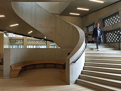
I should at this point mention thestairs. A grand staircase sweeps up the centre of the building from the basement to the fourth floor, curving and twisting irregularly as it goes. This provides more than just a connection, it's a promenade for visitors, a route to help you feel at one with the building. Or there are lifts, one set just running from zero to four, while the bank opposite rises all the way to the top. And everybody wants to go to the top, because that's where the viewing gallery is, so this weekend the 0-10 lifts have been hugely oversubscribed. Long queues have built up by The Tanks, which are temporarily the only point of access, as humanity attempts to squeeze in and ascend. It won't always be this bad, but there is another way to reach floor 10 which is to take the smaller unsigned staircase from floor 4. You'll need to be fit because there are 242 steps, indeed the entire staircase from basement to summit has 408! But you will arrive smugly on the roof, plus you'll get to peer at all the other levels inbetween. Going up.
5: There's no further public art to see, although this level is devoted to dialogue about art and will open up to a programme of events from September. Going up. 6: This level has two rooms, both being used (and to be used) as event spaces. Going up. 7: This level is staff only, so the lift lobby is an oasis of calm on your upward ascent. Going up. 8: This level houses the Members Room, a counterpoint to the Members Bar at the top of the Boiler House. Going up. 9: And here's the restaurant, because any modern art gallery lives or dies by its foodie offering these days. This one has a particularly large plate glass window allowing those ascending the stairs to peer in at the immaculately laid tables, so try not to get seated too close to it. Going up.
10: Finally, be it by lift or by stairs, you'll reach the top floor. Brilliantly this is a viewing gallery with terraces along all four sides of the building allowing 360° views. From the front that's across the multifarious roofs of Tate Modern towards the Thames, with the brick chimney and St Paul's Cathedral the two dominant features. To the side that's across towards the Shard, whose viewing gallery may be considerably higher but also costs infinitely more to visit, so I can see the Switch House becoming a vantage point of choice for many Londoners. And round the back are the residential towers of Neo Bankside, whose exo-skeleton design saw them shortlisted for the Stirling Prize, but whose residents now find themselves being stared at by artlovers wielding zoomable cameras. I watched one couple in their triangular glass living room sitting down for lunch, and another resident opening up a copy of the Financial Times with a cup of coffee. Perhaps you had to be an exhibitionist to want to live so openly in the first place, but many may now be regretting their luxury purchase and its lost Thames view.
So that's the Switch House, a massive undertaking and I'd say a great success. Tate Modern is already London's most popular visitor attraction and now has space to breathe and space to grow. A journey round the new building genuinely feels like an adventure, the irregular nature of the rooms and passageways inviting personal discovery. It makes the 'old' Boiler House look positively predictable by comparison, but that still has more to see, and might even be rather quieter now this overspill has opened. Whatever, it's now a lot easier to spend much more of your day at Tate Modern, or to dip back in repeatedly to a building you'll learn to know well. [40 photos]
Switch House, the brick ziggurat behind Tate Modern, opened to the public yesterday. It's packed with space and levels, and partly full of art. I'll tell you all about it tomorrow. In the meantime, here are some photos.
It had trams. Unfortunately it also had Morden in the wrong fare zone.
Nobody spotted that Morden was in the tram zone before the tube map went to print. Thankfully they did spot the erroneous National Rail symbol at Mitcham, and shifted it to Mitcham Junction instead, before pressing the button. But Morden slipped through, onto hundreds of poster maps destined for station walls, and millions of paper maps destined for ticket hall racks. It was an expensive blunder.
TfL's plan had been to start distributing the new maps in the week ending Friday 3rd June. Normally they don't reveal their launch schedule in advance but this time, because of the big tram reveal, they did.
Once the new map had been released to the media, it didn't take long before eagle-eyed readers spotted the Morden blunder. Ouch.
It wasn't hard to amend the error on the digital map, and the corrected version appeared on the TfL website from Friday 3rd June as planned.
But as for the paper version, TfL suddenly had millions of incorrectly printed tube maps on their hands. A brand new print run had to be paid for, and the intended launch date was silently postponed.
Boxes of the new June 2016 tube maps had already been sent to stations at this point, ready for wider distribution, but now they had to be recalled. Except at High Street Kensington, it seems, where staff accidentally put them out on display in the racks, and dished them out to passing tourists by the ticket gates. And those incorrect maps carried on being available for over a fortnight before somebody eventually noticed.
Finally yesterday, a couple of weeks later than intended, corrected reprinted versions of the new June 2016 tube map started to appear at tube stations. They're going up in poster frames on platforms, and they're starting to be available for passengers to take away, as of this weekend.
Which means there are now two different versions of the June 2016 paper tube map - one an updated reprint of the other. Both versions have a threaded eye on the front cover, both versions have trams, and both versions have a dotted line to represent major engineering work on the London Overground. But the first version had Morden in the wrong fare zone, and the new version places it properly in zone 4.
It's embarrassing for TfL to have made so public a mistake, especially on a map which declares itself on the back cover to be "one of the most iconic designs in transport". It's unhelpful to have delayed publication, because for the last two weeks Overground customers have been seeing out of date maps which didn't show their line has been closed. And it's an expensive error, because to print a half-year supply of 12 million tube maps costs TfL £100000, and they've just been forced to reprint an entire delivery.
Fortunately for TfL, nobody in the wider world has noticed their mistake. Normally the media go wild for tube map news stories - you only have to fire a press release with a tweaked tube map at them and they publish it with glee. But as for the official tube map having been printed with an actual error on it, and then reprinted (at a cost to Londoners), it seems this isn't news. So that's a bullet dodged.
You'll be able to pick up copies of the corrected June 2016 tube map in stations for the rest of the year. But if you were lucky enough to pick up a copy of the incorrect map that nobody else will ever see, you probably have a collector's item on your hands. I wish I'd picked up more...
Quietways are new. These backstreet cycle routes should be old by now - they were supposed to start opening in May last year. But the first (of seven) only opened thisweek, that's Quietway 1 from Waterloo to Greenwich.
These aren't cycle superhighways, they follow lightly-used backroads where segregated lanes aren't required, which you'd think would make them easier to set up. Not so. Plans have to be agreed with local councils - in this case there are four - whereas cycle superhighways tend to run on TfL-run roads. With each street a Quietway turns down, a different set of issues arises and a different set of residents must be taken into account. And London doesn't have a straight-forward grid of identikit roads, so the end result varies considerably along the six mile route.
I haven't ridden Quietway 1, so for a cyclist's eye view you should read this in-depth report on the As Easy As Riding A Bike blog. But I have walked it all, and I can confirm that AEARAB has called it right - mostly good, but with intermittent issues.
For a start, the roads genuinely are quiet. That's impressive, given that you'd normally head from Waterloo to Greenwich along something busy like the Old Kent Road, but Quietway 1 successfully threads between the main roads and helps keep cyclists out of danger. Most importantly it manages to link these quiet bits together, to make a ride of it, with more complex infrastructure only where busier roads cross. Some roads on Q1 have been sealed at one end by posts to make them impermeable to larger vehicles, while some have had ramps added to slow traffic down, and others were always this quiet.
The ramped roads are the least convincing. I don't think I'd have enjoyed riding down Great Suffolk Street in SE1, manoeuvring past two-way traffic and parked-up construction vehicles, neither would meeting the boy racer on Childers Street in Deptford have been fun. But half-posted Cornwall Street near Waterloo looked a breeze, and the lengthy run of estate roads and cul-de-sacs to the north of the Old Kent Road was about as non-threatening as it comes. That last section's nothing new, it's part of an existing cycle route, but other sections have been added more recently to make the Quietway work.
The most impressive of these is the new path round the back of Millwall football ground. This part of London is characterised by a veritable delta of railway viaducts, and at Bolina Road one of the most oppressivebackstreets in inner London. Instead Quietway users get to take a broad raised path from just outside South Bermondsey station to the Overground bridge where Surrey Canal Road station may one day be built, with views of The Den along the way. Indeed at one point there's a damned good view between the stands onto one end of the pitch... which may be why this path will be sealed off from 2 hours before until 2 hours after any Millwall game, and if there is an alternative route it wasn't well signed.
A few roads do have segregated lanes for bikes, occasionally dualled, and this is occasionally necessary. It's harder to work out why Tabard Street in Borough has been afforded this luxury, indeed I saw two cyclists trying to enter the adjacent park for whom the segregation was a frustrating barrier. And then there's one inexplicable case of residential hostility in nearby Trinity Street where an ornamental chicane has been installed across the road. This (gorgeous) road is otherwise ideal to cycle down, being both broad and quiet, but then comes precisely the deterrent that Quietways were supposed to do away with, and I watched one cyclist simply ride up onto the pavement to avoid it.
Many of the road junctions the Quietway crosses have been upgraded, especially where a quiet street meets a busier one. Variegated grey tiling is often used in an attempt to encourage a slower pace, while elsewhere traffic signals with countdown aid the flow. It generally seems to work well. But some of the improvements are more low-key than they could be, for example at an underwhelming staggered junction on Tower Bridge Road, while at others cyclists are simply expected to zigzag through whatever's already there, which might even mean getting off.
One issue I encountered whilst trying to walk the Quietway is that it's not always particularly well signed. A cycle superhighway is easy to follow because it's blue, and generally straight, but Quietways aren't so obvious, marked only by having "Q1" painted on the road and the occasional purple sign at what are deemed key points. Usually that works, indeed I suspect it works better if you're on a bike and literally reading the road. But I wandered off the correct track at least three times thanks to rationed or ambiguous signage, in one case because a truck had parked on top of the painted arrow at an unexpected turning and there were no signs above tarmac height. At other junctions I had a strong hunch which way to go but nothing to confirm, or was briefly baffled by a directional sign which must have been clear to whoever installed it but wasn't to me.
Oddly the worst signed sections of Quietway 1 are at the very beginning and at the very end. There's absolutely nothing at the south end of Waterloo Bridge to indicate that a safe cycle route exists close by, only a hairpin bend back down to South Bank level which just happens to have a 'Q1' painted right at the very end. Similarly the signage at Greenwich DLR is contradictory and incomplete, indicating two different directions and then nothing whatsoever as the path heads off through a private development, which is nowhere near good enough.
TfL do provide an overview map, but alas it isn't detailed enough to be able to make decisions on the ground junction by junction, indeed I'd say the combination of map and road signage isn't quite fit for purpose. But then Quietway 1 isn't meant to be a one-off track for sightseeing, more a regular route for commuters and local travellers, and once you know where you're going then all that ambiguity disappears. And then what you have is what was intended, a six mile corridor that's safer than the surrounding roads and hence a better way to travel. I wouldn't bother walking it, there's very little of interest to see, but if subsequent Quietways can reach this standard then I might well recommend a ride.
I'm pleased to be able to report that the Cycle Superhighway upgrade works at Bus Stop M appear to be finished.
And it only took ten months.
July 2015: There are 3 eastbound bus stops between Bow Church and the Bow Roundabout, two by the church (E and G) and one by the roundabout (M) August 2015: Bus Stop G is dug up to create a bus stop bypass, so all buses now stop at Bus Stop E. The road alongside is narrowed from three lanes to two. September 2015: Bus Stop M is permanently closed, and its pole is moved to the site of former Bus Stop G. October 2015: Former Bus Stop G reopens, now renamed Bus Stop M. Bus Stop E is permanently closed. The transfer of services from E to G, now M, is spectacularly mismanaged. November 2015: Digital data regarding the three bus stops is mostly fixed. A new lamppost appears beside the bus stop bypass rather than in it, but is not yet switched on. December 2015: Timetables at the stop are updated, and a bus map is installed in the shelter. December 2015 - April 2016: Bus stop bypass appears complete, but remains blocked by orange plastic barriers. May 2016: Bus stop bypass is finally opened. Lamppost is finally switched on. Countdown display installed in bus shelter. Bus stop pole is carted away on the back of a lorry. June 2016: Bus stop pole returns. Bus Stop M and bus stop bypass now fully functional.
Why the pole for Bus Stop M needed to be carted off for four weeks is a mystery, especially just when it looked like everything else was finally complete. But suddenly it's back, seemingly exactly the same as before, and the good people of Bow can now catch their buses as intended.
So I thought this was finally the time to tell you about the other inbuilt design fault at Bus Stop M, which has been glaringly obvious since last summer, but I didn't want to mention it until I was sure we'd reached 'Final Configuration'.
Actually we might not be quite there yet, because I think this yellow board is supposed to have a sign on it, but that's probably just an oversight.
As one of TfL's new bus stop bypasses, you'd expect Bus Stop M to have all the usual features, and indeed it does. Specifically that's a cycle lane round the back of the bus stop, which keeps cyclists safely out of the way of traffic and stopped buses, plus a long thin 'pavement island' beside the road where passengers now wait. The awkward bit for pedestrians is that they now have to cross a bike lane to get to or from the bus stop, and that means crossing the path of oncoming bikes.
TfL have of course considered this and created a crossing point, centrally, where the cycle lane rises up to pavement level and where pedestrians are meant to cross. They don't, of course. Some do, especially those with pushchairs, but the majority wander across the cycle lane wherever's easiest, which is usually either at one end of the island or the other depending on which way they're going. Sometimes they even treat the blue strip as an extension of the bus stop and stand in it while they're waiting.
None of this is good if you're on a bike. But none of this is unusual.
What's unusual is that Bus Stop M doesn't have one island, it has two.
Finding space for a bus stop bypass along this stretch of Bow Road proved problematic. Diverting a cycle lane behind a bus stop eats up a lot of pavement, which narrowed the options somewhat (indeed it's the main reason there's now only one bus stop here where there used to be three). It's also not a good idea to place a bus stop bypass in front of any premises with vehicle access, and here this issue proved insurmountable. The optimal site proved to be inbetween the Bow Arts Trust and the Metropolitan Police Garage, both of which have considerable need of vehicle access, and this has been maintained. But there's also a residential block between the two with car parking round the back, and this clashed directly with the selected bus stop bypass location.
TfL's solution was to chop the bus stop bypass in half, allowing residents to drive in and out through the middle. The front half is slightly longer, and contains the bus stop, the bus shelter and almost all of the passengers. And the back half is shorter, and generally empty, but still technically necessary to create a facility of adequate length.
So here's the rub. If only one bus turns up, no problem, everybody gets on and gets off fine. But if a second bus turns up, the configuration of the bus stop means that the doors open in the middle bit.
Generally the front of the second bus pulls up beside the back of the first bus stop island, so that's fine. Here's a man with a walking stick getting on.
But the middle doors almost always open in the gap, where the cars drive in and out, and where there's no raised pavement. Here's a lady with a pushchair and a small child getting off.
TfL rightly make a big thing of bus stop accessibility, indeed they have a target that "95% of all bus stops in London will be accessible by December 2016". In particular "the ideal range in terms of kerb height is 125–140mm, however 100mm is the minimum for it to be compliant". But arrive on the second bus at Bus Stop M and there's no kerb at all, which fails the accessibility test outright.
Obviously if you're in the second bus in a wheelchair, the driver will wait until the first bus leaves and move forward, or hang back and stop on the other island, so that the ramp can be deployed. In this respect Bus Stop M is probably technically accessible. But generally the second bus pulls in at the gap, and those with limited mobility or pushchairs are forced to step down further than necessary - I've watched it happen many times.
One solution would be for the second bus to always hold back and stop beside the second island. However that's not going to work long term because Bus Stop M has to cope with over 40 buses an hour, so there needs to be space for a third bus to pull up behind.
A simpler solution would be for the first bus to stop a little further ahead than it does now - there's room - which would allow the second bus to stop with all its doors alongside the first island. Indeed a few 'first' bus drivers already do this, stopping beside the front of the bus shelter and leaving sufficient room behind. But most drivers naturally stop beside the back of the bus shelter, because that's where the bus stop pole is, and where it's considerably easier for those waiting all around to board.
Shifting the bus stop pole a few metres forward would entirely solve the "second bus access" problem. Unfortunately it would create fresh issues with boarding the first bus, with access now only from the sharp point of the island, past the shelter, and much harder for those with pushchairs or wheelchairs to reach. It seems there is no optimal solution here, which is why no optimal solution has been imposed.
Still, at least it's better now than it was last autumn when the bus stop bypass was first built. Some idiot planted one of those yellow warning signs by the kerb at the back of the first island, where it totally got in the way of anyone trying to board the second bus. That lasted a couple of months before somebody else thankfully noticed, and had the sign completely removed.
Another issue when the bypass was first built was the lack of direct step-free access from one half of the island to the other. Anyone with mobility issues alighting on the rear island was expected to cross the cycle lane to the pavement, proceed up the pavement and then cross back onto the other island if they wanted to catch another bus. Again, thankfully, somebody spotted this, but it required additional roadworks to introduce dropped kerbs either side of the central gap, wasting funds by having to build these bits of the island twice.
So the final configuration of Bus Stop M is better, but still doesn't quite work. It's a bus stop in two parts, a bus stop with a hole in it, where you might be dropped off onto the kerb or you might not. It's hugely better for cyclists, who can now whizz by in safety, but not quite as good for bus passengers as what was here before. Not everybody wins out when a Cycle Superhighway passes through. Let's hope that TfL learns to mitigate the downsides as plans roll out elsewhere, so that nobody in any other part of London need ever suffer the fiasco that has been Bus Stop M.
There are three great museums at South Kensington - the Natural History Museum, the Science Museum and the V&A. But there used to be a fourth, indeed there still is, except it's been entirely swallowed up by one of the big three. The Geological Museum started out on Jermyn Street in 1835, then known as The Museum of Practical Geology, and was essentially a collection of rocks. A century later it had outgrown its premises so looked to move on to Albertopolis (the original site became the flagship store of Simpsons menswear, now Waterstones on Piccadilly). In 1935 the museum moved into a new building on Exhibition Road squeezed inbetween the Science Museum and Natural History Museum, on land earmarked for an extension of the latter. Only in 1973 was a physical public connection created between the Geological Museum and Natural History Museum, with a full merger of the two bodies taking place in 1986.
Which means most people visiting the Natural History Museum think of it as a place devoted to animals and maybe plants, but probably not rocks. Indeed if you enter via the main hall where the diplodocus lingers, you might never find your way to the geological bit at all. It's off to the right on the ground floor past the fossils and creepy crawlies, then you have to think to walk all the way past the stuffed birds and there's geology, now rebranded as the 'Red Zone'. Alternatively if you come in direct from Exhibition Road you walk straight in, because that was the original entrance to the Geological Museum (top tip, on busy days it has a much shorter queue), and then your first experience of the NHM is earth science rather than dinosaurs.
Visitors to this part of the museum didn't usually make it up as far as the top galleries, so in 1996 a single escalator was added to try to lure folk up to the second floor. It's almost irresistible. Rising up through the middle of the main atrium it passes between a backdrop overpainted with constellations and through the raging core of the Earth. Obviously it's not the real Earth, merely a globe constructed from thin sheets of bashed metal, and those aren't incandescent flames, merely a bit of red lighting. But it's effective enough, and it serves its purpose to deliver you to the volcano and earthquake bits upstairs.
Everybody likes the volcano and earthquake bits, because they're a reminder of our planet's immense capability to transform and kill. A series of displays, some with buttons to press, allow you to explore where the world's most active volcanoes are and the many different forms they take. If the lava doesn't get you then the burning gases might, and if they pass you by then the ash cloud could still spread round the world and drag the temperature down, so be warned. A theme which shines through is how magnitude and rarity are connected, so if the panel on supervolcanoes scares you, be reassured that none has erupted since humanity began. As for earthquakes the display is right up to date with footage of the Japanese tsunami, but what every visitor wants to do is stand in the Kobe supermarket simulator (circa 1995) and be shaken for 20 seconds, as meekly as health and safety will allow.
On the opposite side of the top floor we get Restless Surface, which is an attempt to make weathering and erosion sound exciting. It almost succeeds, with frozen lightning pierced through sand and a giant stalagmite hewn in two, but I expect most kids rush through until they find a tray they can drip water into (to show how river deltas and meanders are formed). They might not linger long either through From The Beginning, a timeline of the evolving Earth spread along the entire length of the building. But I rather enjoyed the dark and dated scientific presentation, fact-dense with graphs and maps, as well as with fossils from the relevant time period. And I learnt plenty too, not least the (to me) surprising fact that Scotland and the Lake District used to be on separate continents across a long-gone ocean until 425 million years ago.
If you like shiny things you'll enjoy Earth's Treasury, which is where the museum finally gets to focus on rocks. Almost everything that makes up the Earth's crust gets a look in, from ubiquitous silica and granite to rare ores and precious stones. The Geological Museum has been gifted several special collections of gems over the years, and these are prominently displayed along with a long sequence of mineral-by-mineral displays. So yes, there's a cabinet of rubies and opals, but also a look at coal and slate, and quartzite and mica, in all their many and magnificent forms. What's intriguing is the significant overlap with another much-loved corner of the Natural History Museum, the Minerals gallery, with its magnificently cabinetted 1881 presentation. That's off-limits at the moment, incidentally, but should reopen by the end of next month once transformation of the main hall's upper balcony is complete.
Once back at ground level in the Red Zone, will you head for the cafe or will you head for the gift shop? The latter is more interesting, not least because it doesn't take up the full length and hides a further gallery on Human Evolution at its rear. Of the eight different species of hominins how come we became dominant, and so recently? And there is one more room you should poke your nose into, which is the London Information office of the British Geological Survey. This is proper old school science, with a study zone and helpdesk, plus a fantastically comprehensive array of publications for purchase. Geological maps and guides to every tiny area of Britain fill one wall, plus some slightly less academic sheets and guides and postcards, and some rocks. "This is my favourite bit," said a man leading his unwilling 5 and 8 year-olds through its portal, "but then I am a geologist".
And after all this there's still the rest of the Natural History Museum to explore, including the dinosaurs and the blue whale and the new-ish experimental wing, to make a proper day of it. And conversely, if you ever turn up and the main building is packed out with families and/or tourists and/or schoolchildren, be reassured there's probably an interesting bit round the back that isn't.
The Queen was 90 fifty days ago, but the weather is supposedly better in June so the official birthday celebrations were held back until this weekend. On Friday she went to a commemorative service, Saturday was the usual Trooping the Colour plus a flypast, and yesterday saw a big street party along The Mall. Called The Patron's Lunch, its aim was to celebrate all the good works done by the hundreds of charities whose patron is the Queen. And it did this by charging each charity £1500 for a trestle table and some nibbles.
The Mall was sealed off overnight so that seventeen hundred tables could be laid out, with a central strip left free to allow the ceremonial to take place. Those with invites were asked to turn up from 10am, so they could all be bodyscanned before potentially meeting a member of the Royal Family, despite no part of the outdoor event kicking off before noon. Whatever they left the house in, by the time they arrived it was raining, and some were already regretting their choice of garb. One bloke in short sleeves and sunglasses dripped alongside his cocktail dressed wife, while others had been so intent to turn up in kilts that they'd given no thought to weather protection whatsoever. The organisers had decreed in advance that umbrellas were banned, presumably for reasons of visibility, so some guests had turned up in ponchos made from binbags before getting their hands on the officially sanctioned semi-transparent version.
For those not fortunate, or rich, enough to have got their hands on a ticket, an alternative means of celebration had been arranged. Were this a football tournament they'd have been called Fan Zones, such are the kind of hardened groupies these places attract, but here they were called Live Sites. And so the devoted found themselves either at the top of Green Park or in the middle of St James's Park, depending on which side of The Mall they were approaching from, with little chance of ever getting round the cordon to the other side. On their way they were greeted by the free Union Jack disher-outers, who are always present on these royal occasions, attempting to ensure that all the flags being waved featured the name of their glossy weekly celeb lifestyle magazine.
The early birds made a beeline for one of two places, either immediately in front of the big screen or round the edge of the seating area beneath a tree. Precipitation levels over the next two hours suggested that those who'd grabbed the limited under-branch space had made the wiser choice. Red, white and blue hats, brollies and jackets were much in evidence, while one middle aged couple sat in beach chairs wearing gold paper crowns as if they were on the throne themselves. A lot of those present were ladies of retirement age, in groups, but many families had also turned up en masse to bear witness to the magic of the monarchy.
There was nothing to watch on the big screen until the event began, nothing except a carousel of marketing messages disguised as information.
At the Patron's Lunch merchandising tent business wasn't brisk for souvenir teatowels or a £7 pack of branded paper cups and plates. All the Celebration Makers seemed busy talking to each other, perhaps because there was as yet nothing to explain, occasionally pausing to hand out a telecommunications-themed flag. The Green Tea Monkey was somewhere inaccessible, which was a shame for anyone hoping urgently for a hot drink. The Entrepreneurs weren't doing a roaring trade, which hopefully taught these youthful trainees about the substantial meteorological risk involved in flogging ice cream in summer. But the company with the most to gain, or lose, was Marks and Spencer.
M&S had taken on the responsibility of providing the contents of the celebration hampers handed out to all the paying guests, an uncollated version of which was available in their pop up shop. This sounded good, but was in truth a temporary room lined with chiller cabinets and racks of crisps, plus a central slalom area leading to the tills. Here you could purchase Four Nations sandwiches and crown-topped pork pies with piccalilli, as well as more ordinary sandwiches (naturally including coronation chicken). To their credit, the price of each item was the same as you'd pay in a supermarket, even down to the 3 for 2 offer on the sandwiches and the half price strawberry punnets. But it was the bottles of soft drink that were selling best, perhaps because the Pimm's tent hadn't yet opened.
As the rain continued to pour down, I left the revellers to it, fleeing past further hordes of charity representatives queueing in uniforms, plastic sheeting and red trousers. They'd need their standard issue ponchos once the event officially began, the precipitation only easing off shortly before the royal walkabout. And by the time the fuchsia pink queen trundled back down The Mall from saying her few words the sun had even come out, and for long enough to allow the parade to take place unsplattered. Thespectacle was probably best seen at home on TV, where at least there was a functioning kettle if not the opportunity to shake a minor royal's hand, plus a red button option to turn off the obsequious commentary.
By 5pm the staff in Westfield's M&S were marking down the pork pies and the smoked salmon in the Patron's Lunch chiller cabinet to half price, and a herd of bargain hunters crowded round to grab some birthday swag for tea. The curtain has now come down on this weekend of official celebration, and ardent monarchists must wait some time for an event of similar magnitude. The Queen's 95th probably won't be celebrated with such gusto, if she gets that far, overshadowed by the potential Platinum Jubilee the following year. As for the possibility of reaching the birthday where she gets to send a telegram to herself, best not enter into undue speculation at this time. But let's hope it's hampers and carriages again next time, whenever that might be.
THE UNLOST RIVERS OF LONDON Beverley Brook Worcester Park → New Malden → Barnes (5½ miles)
[Beverley Brook → Thames]
For the second part of my walk along the Beverley Brook, an unlost river in southwest London, I'm following a trail rather than the river. This is an important distinction, because the Beverley Brook Walk is attempting to create a decent afternoon out rather than slavishly following the river. In this it succeeds, rather well, but occasionally at the expense of seeing any water. That said, there are two long brookside stretches through Wimbledon Common and Richmond Park, and they're better than anything a lot of London's other unlost rivers can ever hope to attain. And hurrah, this is an official waymarked walk, so there are generally signs to follow and you can also download a leaflet. You can't go wrong with Beverley. [OS map][Google map][river map][walking instructions][9 photos]
The Beverley Brook Walk kicks off by a bus stop on the A3, which isn't the easiest spot to get to, so a ¾ mile walking link exists from New Malden station. Or you could catch the bus instead, although interestingly the 265 tracks the river closely from here all the way to Putney so you might be spoiling the surprise. There's the river in a deep wide trench emerging from beneath the dual carriageway, and make the most, because after 100 metres it's vanishing again behind some houses. Instead you get to walk round to the shops by the Coombe Lane roundabout, which are also the last set of shops along this walk so best stock up if necessary.
Other than the clue in its name, Beverley Avenue doesn't look a very promising way to go, neither does the footpath at the end look especially appealing. When it squeezes round the back of a sports ground along a nettle-y path it'd be unwise to attempt in shorts, you may be even less convinced you're on the right track. But things open out past the tennis courts, crossing the edge of a rugby ground so behind the times they still use scrummage aids sponsored by Powergen. And an enamelled map beyond the touchline confirms you're on the right route, indeed you're at the very southwestern corner of Wimbledon Common. All the main facilities are a long way distant, this is deep woodland fringe, and probably all the better for it.
For the next mile the river runs immediately to your left beneath a thick leafy canopy. The first time I walked this way I thought it was natural, but looking again it's clear the hand of man has been at work. The brook hereabouts is about six metres wide, and consistently so, hemmed in by a run of wooden boards that create a curve too artificially smooth. The banks are deep and rather steep, and consistently so, meaning you're always up above the stream and never down at its level. However charming the brook appears it's really a drainage channel with potential high capacity, but then so many London rivers are, indeed have to be to prevent flooding to adjacent properties. Here there are no houses, only oak woodland and muddy tracks, and the rural illusion would be complete were it not for the rumble of the A3 running parallel to the far bank.
So anyway, that bit's lovely, and it's a pity when you finally step back out into the open by some playing fields. It's time to finally leave the A3 behind, but only after crossing it, which is achieved via a pair of lights with dual control for those on foot and those on horseback. Never fear, the brush with mainstream civilisation is only brief, because on the other side is Richmond Park's Robin Hood Gate. An old plaque on the brickwork confirms the Roehampton Gate is 1 mile 530 yards away, which is where both we and the river are heading. To follow it turn right inside the park to follow it up the eastern boundary, because the local golf course swallowed up everything on the far bank.
Again this is nice, with a path following the river all the way, only this time in broad daylight. Only the occasional tree intrudes, apart from a brief spell through somewhere called Killcat Wood, which sounds far more unpleasant than it is. And yet the river again has a certain uniformity, a result of its canalisation in the 1920s to create a channel deeper and safer but ecologically sterile. Which is why the Royal Parks have a restoration project underway about halfway up, with a 500m section fenced off to prevent damage from dogs and deer, and to allow the re-creation of less precipitous banks and differential shallows. This'll improve biodiversity by giving fish somewhere to lurk, even spawn, and increase the amount of in-flow vegetation. It might even be working, if the hungry heron I saw jabbering on a tree stump was anything to go by.
After the cafe and several deer, if you're lucky, the brook ducks under a wall to leave the park. The official path eventually follows, then runs alongside for the length of Palewell Playing Fields. Make the most of it, because beyond the pitch and putt course the route suddenly breaks away to exit the riverside through some rather nice allotments. Things you won't be seeing on the opposite bank include the National Tennis Centre and The Priory, if you've ever wondered precisely where celebs go for therapy. Instead there's a lot of road walking ahead, the only vaguely interesting bit a diversion via Priest's Bridge (where there is indeed a bridge), as well as the Halfway House (which is somehow the only pub on the entire walk).
Take care walking up Vine Road, which is the location of the Barnes double level crossing, where you'll probably be stopped twice by commuter services. Eventually it's possible to step out onto Barnes Common, where the official route makes a brief dash for the footbridge at Barnes Green where the river reappears, then immediately retreats. The Common's very pleasant, and very popular, although if you've come on this walk for liquid scenery you'll be wondering where that's gone. By this point the Beverley Brook has bent round to flow east rather than north, and is heading for the Thames on the opposite side of the Barnes meander. Meanwhile the path is running parallel about a hundred metres away, passing between a large sports centre and a derelict cemetery with tumbledown monuments and the occasional headless angel.
Finally, with barely quarter of a mile to spare, the Beverley Brook Walk and its associated river recombine. A footbridge returns you to a bankside path, with the river somehow not as wide and voluminous as geomorphology suggests it should be, as if a substantial part of the flow has been removed somewhere upstream. One last leafy promenade delivers you to one final bend, where a sluice traps any waterborne detritus before it exits the river. There's a considerable differential in height from one side to the other, the last few upstream metres being entirely tidal and resembling more a dock or inlet than the mouth of a river. And we're done, the prize being a stately panorama along the Thames, with Craven Cottage almost immediately opposite, and Putney Bridge in the distance beyond a string of boathouses. Thank you Beverley, you certainly delivered.

Quietways are new. These backstreet cycle routes should be old by now - they were supposed to start opening in May last year. But the first (of seven) only opened this week, that's Quietway 1 from Waterloo to Greenwich.