WALK LONDON The London Loop[section 22]
Harold Wood to Upminster Bridge (4½ miles)
This is an easy stroll, with some interesting bits (and some less interesting road-walking). Section 22 runs through one of London's least known corners, the "beyond Romford" bit of Havering. It follows the Ingrebourne Valley, or tries to, because sightings of the river are alas infrequent. And it ends up at the least busy station on the District line, which is why I'm walking it this month. [map]
In a few years Harold Wood is going to be the last Crossrail station inside London heading east. For now it's rather quieter - just three of us alighted on Sunday afternoon, emerging onto the delightfully-named Gubbins Lane. The Loop heads into a quiet estate, past a self-service supermarket oddly titled "Bargain Booze", and a bevy of auto services outlets. Archibald Road is a one-sided gravel drive facing out across some allotments - the last road in London before the countryside takes over. At the end is the also-delightfully-named Cockabourne Bridge, with the narrow river Ingrebourne flowing beneath. It's quite pretty, in a minimalist reedy way, although you'll only get the chance to peer over if you deviate from the Loop's nearby path.
Harold Wood Park is a pleasant greenspace, bounded by trees, and well used. It's the only park I've ever seen with Oral History Waymarker Boards, where locals recount their memories of playtimes gone by, and also the only park I've ever seen with a specific "Teenage Area". Appropriately-aged sportspeople were all over the place, including a very-official all-girls cricket match, and what looked like a herd of One Direction clones kicking a football about. I passed a Scooby-Doo themed ice cream van dispensing blue-filled cornets to grateful infants, then walked on to cross a footbridge above the Ingrebourne. There's supposed to be a welcome arch here, a St-Louis-shaped curve made from wood and painted in rainbow colours, but that's mysteriously disappeared.
The 'Welcome' is for entry into Pages Wood, the Forestry Commission's largest plantation in these parts. They've been building up patches of woodland over the last decade or so to create Thames Chase, one of the UK's twelve community forests, down the eastern side of the borough of Havering. Pages Wood started out as recently as 2001, and its hundred thousand trees have now sprouted high enough to make the end result sort-of imaginable. For now they grow behind a protective fence, but a network of all-weather paths slink through across the site, ideal (and very safe) for junior cyclists. The air was filled with thistledown, and the low grass brimming with teasels. At one point there's a bench shaped (sort of) like a duck, at another a track leads across the river to an expansive but overlooked meadow. The more Iuncover of Thames Chase the more I like it, although it's rarely seemed busy, and I suspect only those fortunate enough to live out this way know of its delights.
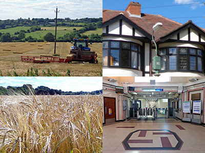
Hall Lane should be a total misery to walk along, not least because the Southend Arterial Road cuts through partway down, but somebody official has ensured not. A broad shared footpath and cycleway runs along one side, avoiding all unpleasant sliproad crossings bar one, thanks to what seems to be a Sustrans project to create a safe attractive bike-friendly route all along the Ingrebourne Valley. I was especially intrigued by the view to the west, with farmland down to the river below, then meadows specked with horses, with the skyscrapers of Canary Wharf and the City clearly visible as silhouettes on the horizon. I'd arrived on harvest day, so in one field the combine harvester was at full pelt with clouds of chaff billowing behind, while baling was taking place in another. Although most never seek it out, London truly has its rural fringe.
A red double decker at the next road junction signalled a return to urbanity, this the northern residential edge of Upminster. Close by is the legendary Upminster Tithe Barn Museum of Nostalgia, which I swear I'll visit one day, except it only opens on alternate weekends and I've never yet managed to hit the right one. Close by also is Upminster Court, an Edwardian mansion built for a wealthy industrialist, very recently restored at great expense for use as a corporate HQ, but alas described as "Upmister Court" on the heritage plaque on the gatepost. But the Loop doesn't pass either this or the Tithe Barn, instead plunging down River Drive (which has some quirkily old lampposts with swan neck brackets and sodium lanterns). Squeeze between the posts at the foot of the drive to enter thick descending woodland, the best minute of the entire walk, where the path must double up as a drainage channel in particularly wet weather.
At the foot of the slope, beyond a brief clearing, a footbridge crosses the river. If you've been following the official Loop route this is only the second time you'll have seen the Ingrebourne, and it's also the last, because it's about to disappear inside a golf course. Instead enjoy the walk along the edge of five fields, the first all grass, the second a school playing field, the third a carpet of waving wheat. You'll have to visit quick to see that, because the fourth and fifth have already been harvested so are now rather stalkier. I should have been enjoying the fresh air, except two local old boys had bonfires going, including the bloke with the horse and two goats in his back garden. And apparently I should have turned round at the top of the final slope to spot Upminster Windmill over the rooftops, but I only read that bit of the instructions later, and I'd been distracted at this precise point by 2013's first sighting of blackberry pickers.
That's it for pretty - a narrow litter-strewn alleyway leads the Loop back to suburbia. I stopped at the parade of shops, causing the member of staff standing outside the convenience store to chuck away her cigarette and dash inside, only for me to buy a can of drink that probably cost less than her discarded fag. Wingletye Lane is the sole road hereabouts to cross the single-track railway line between Emerson Park and Upminster, so the Loop has to go this way, and then it's a short trudge to the District line station. This is Upminster Bridge, named after a river crossing on Loop section 23, and one of the few stations on the network where TfL no longer deem it necessary to run a ticket office. The 'ticket hall' is splendidly 1930s, with purple glassbrick skylights, K6 red telephone box and the notorious swastika tiling on the floor. Rest awhile on the unique curved benches on the platform, if you're heading home, or else it's only four miles to continue along the Loop to Rainham, and you'll actually see the river this time.
The Watford Observer announced this week that the two new stations on the Croxley Rail Link have finally been named. There had been expectations, early on, that the station near the hospital would be called Watford Hospital because a major health campus is being created close by. But what a rubbish name that would have been, hardly something to attract Londoners to visit, and completely ignoring the area's star attraction. Watford Football Club play nearby at Vicarage Road, plus Vicarage Road is precisely the name of the road the station will be on, even if it's a bit of a backwater lane this far down. Mayor of Watford Dorothy Thornhill fought a star campaign to get TfL to give the station a more appropriate name, and it appears she's been successful.
Even the BBC website reported the good news about Vicarage Road, under the headline New Watford tube station to be called Vicarage Road. Except, if you read the Observer article more carefully, that's not actually true. It seems TfL don't like naming stations after roads because they're a bit parochial and don't mean enough to those living elsewhere. Watford's football connection finally persuaded them otherwise on this occasion, but they're not going to allow it to be called plain Vicarage Road. Instead it'll be Watford Vicarage Road, a clunky amalgam of town and location, and a bit of an unlovely mouthful. To be fair, the next station up the line will be Watford High Street, which is a name already in precisely the same town/road format. But it's a shame that the Station Naming Committee (or whatever) didn't have the confidence to run with the shorter, snappier, less artificial title.
Imagine if this "town+road" rule had been in place in the past. Baker Street would have had to be Marylebone Baker Street, and Bond Street might have ended up Mayfair Bond Street. We could also have been lumbered with Walthamstow Blackhorse Road, Moorfields Old Street, Holloway Caledonian Road, Harringay Turnpike Lane, Shepherd's Bush Wood Lane, Park Royal Hanger Lane, West Hampstead Finchley Road, North Kensington Latimer Road and Queen Elizabeth Olympic Park Pudding Mill Lane. I don't think anyone would have gone quite so far as Bow Bow Road or Fulham Fulham Broadway, but where TfL bureaucracy is concerned you never know.
At 19 letters long, Watford Vicarage Road will be one of the longest names on the London Underground network. Not the longest, which remains a tie between Heathrow Terminals 1,2,3 and Kensington High Street. But equally as long as King's Cross St Pancras, Great Portland Street, Shepherd's Bush Market and Totteridge & Whetstone. Head onto the DLR and Stratford International is even longer, while the Overground holds the TfL record with Caledonian Road & Barnsbury. I think that's the longest station name in London, unless you know better, although beaten by Southampton Airport Parkway across the wider rail network. Whatever, it seems as if the length of station names is slowly edging up as those in charge of nomenclature attempt to keep every local interest happy.
And then there's the other new station on the Croxley Rail Link, the halt near the boundary with Croxley Green. The intention had always been to call it Ascot Road, because that's the road it's on, and that's the name that's appeared on all official documents. But that won't now be the case. 'Ascot Road' really would mean nothing to those living further away, and could easily be confused with Ascot in Berkshire, so it's been dropped. Instead the confirmed name, without a space, is Cassiobridge. Again that's hardly familiar to any non Watfordians, but it is a name with an impeccable historicpedigree. In pre-Roman times a tribe called the “Cassii” or “Cashio” lived in the local area, and it's the manor of Cassio, not Watford, which is mentioned in the Domesday Book. The Earls of Essex lived at CassioburyHouse for 250 years, their estate now an extensivepark and housing estate, while the hamlet of Cassio lay along the Hempstead Road. But where the main road crossed the River Gade, and later the Grand Union Canal, that's always been Cassio Bridge. I used to cross it daily to get to school, and now it's to be immortalised on the tube map.
There are still three years to go before the Metropolitan line extension opens. Instead of a single station called Watford, awkwardly placed for the town centre, there'll be three Watford stations each declaring their specific location. Commuters near Cassiobury Park won't be happy, but at least everyone else will know where to get off.
The next station is Croxley
The next station is Cassiobridge
The next station is Watford Vicarage Road
The next station is Watford High Street
The next station is Watford Junction, where this train terminates
A year ago, on the last weekend of the Olympics, you couldn't get into the Olympic Park without a ticket for love nor money. This weekend, it's considerably easier. Queen Elizabeth Olympic Park was quiet enough on reopening day, so I wondered if it was any busier yet. It's high summer, it's the school holidays, and the Park's had a big publicity boost over the last fortnight. So I returned yesterday afternoon, and it was a bit busier, and simultaneously not really. Here's how QEOP is now.
• The park: It's not exactly empty, but you can easily find a lot of space all to yourself. One lady had claimed the wooden seating blocks to read a book, and a mum and daughter were yapping by the reeds near the southern steps, but otherwise the western half of the park was free of malingerers. I had the gorgeous sloping lawn near the Media Centre all to myself, and could have plonked down to read the paper or nibble a picnic if only I'd thought to bring one with me. Most visitors headed straight across the main bridge to the eastern half where the cafe and playground are, and even then failed to descend to the parkland beside the river. A few folk with cameras toured the quieter bits searching for landscapes to snap, and a few joggers were out beating fresh new running routes, because if you lived nearby you'd take advantage too. 2012's buzz may have vanished, but plenty of sparkle remains.
• The security: It felt like security overkill on the day the park first reopened to the public. Thankfully that's eased back somewhat now, but QEOP still has more tabarded stewards than your average park. I'd say about ten to a dozen, mostly wandering round in pairs rather than pointedly guarding the entrance. Some are needed on the main bridge because that's a route for construction vehicles approaching the East Village. Meanwhile a lot of the guards gather on the northern bridge for a lengthy natter before moving on, which is presumably acceptable because this is a fantastic vantage point, although there are barely any members of the public this far up.
• The cafe: It's doing well, by the looks of it, the eaterie at the Timber Lodge. There are people sat outside at tables. There are families walking away from the counter with meals on trays. I'm not sure if the yoga sessions in the event space round the back are going well, but good news, the cafe a long way from anywhere has customers.
• The playground: Maybe the cafe has customers because of this. The Tumbling Bay playground is rather excellent, as wood-based clambering locations go, and was being well used (if not over-used) yesterday. I heard shrieks of happiness from somewhere up in the trunky bits, and spotted several parents sat round on the lawns overseeing their offspring, and I wondered if adults were allowed aboard late in the evening after all the kids have gone home.
• The flags: Alas, a few bits of the playground are already flagged off. Some wooden stepping stones across a ditch have been 'sealed' by a perimeter of bunting - but only one set, the others are still accessible. The pathways through a garden enclave have been similarly blocked, as if something inside needs protection from tiny feet. It's not ideal, so early in the facility's life, but presumably someone'll sort out the issues soon.
• The bunting: It's not just the playground with blocked paths. A number of borders and cut-throughs in the eastern half of the park now have bunting draped across in an attempt to stop park users from taking a shortcut. A fortnight ago there were a few but now there are a lot more, in the hope that flimsy flags on string will protect the borders and plantlife beyond. The borders are *nothing* compared to how pretty they were this time last year, but it's the same problem as back then, as punters on desire line paths engage in thoughtless trampledown across the site. And I'm sorry, but I blame the Olympic Park's designers. They created an attractive network of twisting paths and elevated lawns, but entirely failed to include sufficient routes to get from one to the other. Sorry, but parkgoers aren't all going to behave like angels and walk round the long way, not when there's a four minute shortcut down a sloping bank. Some of the dead ends exist because not all of the park is open yet, so we can forgive those, but others appear to be deliberate, and there's one major dogleg near the northern bridge which pretty much urges you to continue straight on. With no security to watch over them, some pleasant corners of QEOP will be eroded fast.
• The tour: Remember the Blue Badge tours which set off from Bromley-by-Bow every morning before the Games to show visitors the Olympic Park from the Greenway? They're still running, but now they leave from Pudding Mill Lane and the guides lead the tour inside the Olympic Park instead. I've never been on one to give a recommendation, but the itinerary suddenly got a whole lot better.
• The festival: QEOP will be sealed off next weekend for the Lollibop festival, which is essentially Lovebox for under 10s, and features appearances from Postman Pat, Rastamouse and Peppa Pig. Family tickets cost in the order of £100, so I'd recommend going to Hackney Wick instead for the free (and fantastic) Hackney Wicked festival. Strongly recommend, in fact, if you like edge and art and studio cool.
• The bus: Hurrah, the 588 bus now stops outside the Copper Box in both directions. What's more, the bus stops are actually being used. Outside the park I spotted a bunch of families with a number of kids waiting for a bus to ride to Stratford, and clambering aboard took at least a minute. It might even take off, this short hop to the park.
• The train: Instead I arrived via Stratford station, where the signs still send you out the long way, then disappear outside the entrance to Westfield. They pick up again if you spot the escalator, then it's a long yomp. It took me just over 15 minutes to get from the platform to the park, and that was yomping fast.
• Biking in from Hackney Wick: Good news! All the security guards between the White Post Lane and the Park have disappeared, or at least they had yesterday afternoon. Now you can cycle in without some jobsworth telling you to get off and walk. Indeed now you can cycle all the way through from Hackney Wick to Stratford for the first time in six years. Sounds good to me.
• Driving in from Hackney Wick: Also the gates at White Post Lane have fully opened, so anyone with a car can drive in via the same route as the bikes, through the edge of the QEOP building site and up to the park entrance. You can't park and go for a picnic, heaven forbid, but you could drive on quickly and easily to Westfield. I wonder how long it'll take before word gets out and the traffic jams appear.
Flood? Fire? Flu? Alien invasion? There is one group of people at City Hall whose job it is to know, and to help us prepare. They're the London Resilience Team, staffed by London Resilience Officers, and they do all sorts of things behind the scenes to keep the capital hazard-ready. Planning for Mass Evacuation. Promoting Business Recovery planning. Developing the London Resilience Partnership Strategy. Coordinating Electricity Disruption workshops. Updating the London Recovery Protocol (which is a disaster recovery plan you'd probably rather not be thinking about).
It should therefore come as no surprise to hear that London has an official risk register. That's the London Risk Register v2.0, a list of potential perils which might beset the capital, ranked by likelihood and impact. Almost 100 "Reasonable Worst Case Scenarios" are considered, each relating to an unplanned event. Communities and businesses are invited to give due consideration to the register's contents so that they remain resilient in the face of heaven knows what. And that's why the plan is shared publicly, providing visibility for forward planning, and scaring the heebeegeebees out of those of a nervous disposition. [pdf]
So, what are the biggest threats to London? The London Resilience Team work this out by rating each risk on a 1 to 5 scale for impact and likelihood, then combining the scores. Impacts rank from Limited (1) to Catastrophic (5), while likelihoods are rated by how likely something is to happen over the next five years (1 in 20000 chance for the lowest category, a 50/50 chance for the highest). This produces a four-point categorisation by colour, with green for the lowest risks and red for the highest. London has four risks in the red zone, four that worry the authorities above all others.
• Severe inland flooding
• Fluvial or surface run-off
• Influenza Pandemic
• Telecommunication failure
Two of the red risks are flood-related. Severe inland flooding could follow sustained heavy rainfall over two weeks, leading to mass evacuation, fatalities, loss of essential services and "significant regional economic damage." Flash flooding or rising river levels would cause more localised damage but could still lead to up to 15000 people being evacuated. Meanwhile influenza could affect up to half of London's population, with 10% of us contacting healthcare professionals in the peak weeks and a fatality rate of up to 2.5%. And just imagine the effects of a 3-day telecommunications failure, with widespread loss of landline and mobile networks, and the emergency services’ communication systems similarly affected. Be afraid, London, be very afraid.
Below is a grid showing a summary of the risk ratings for some of the risks in London's Risk Register. The scale up the side is Impact, and the scale along the bottom is Likelihood. The nearer the top right-hand corner, the scarier. I've been selective, so less than half of the official total number of risks appear below. But the bottom row really is that empty, because the Resilience Team don't bother to include every minor fear or worry.
London's Risk Register June 2013 - Summary of Risk Ratings
5
» Large toxic chemical release
» Major reservoir or dam failure
» Local fluvial flooding
» National electricity failure
» Telecommunication failure
» Severe inland flooding
4
» Aviation accident over an urban area
» Loss of drinking water due to major accident
» Accident involving transport of hazardous chemicals
» Drought
» Fluvial or surface run-off
» Influenza pandemic
3
» Land movement
» Bridge collapse
» Localised explosion at natural gas main
» Accident involving transport of fuel or explosives
» Large building collapse
» Pathogen released
» Storms and gales
» Low temps and heavy snow
» Emerging infectious diseases
» Influenza epidemic
» Major coastal and tidal flooding
» Railway accident
» Loss of emergency fire and rescue cover because of industrial action
2
» Forest or moorland fire
» Industrial action by key rail workers
» Industrial explosions and major fires
» Animal diseases
» Constraint on fuel supply at filling stations
» Heatwave
» Influx of British Nationals
» Building collapse
» Loss of local telecommunications
1
» Local accident on motorways and major trunk roads
Low risk
Medium risk
High risk
And not an alien invasion in sight. If all of this is proving interesting, perhaps you'd like to follow London Prepared on Twitter to keep up with what's going down. Or you could like the London Prepared Facebook page, which is currently engaged in a week-long quiz about Warning Signs. Both would of course be useless in the face of a major communications infrastructure failure, but at least you might have learnt something useful to prepare you for the worst. And the London Resilience Team even have their own blog, updated weekly, tucked away on the london.gov.uk website. Last week's Duty Officer Update featured news on water supply disruption and planned road closures, whilst reminding Londoners that "the threat level from International terrorism remains at Substantial." I'll certainly be checking back today for this week's update, just in case...
50 years ago today, as the media will no doubt insist on repeatedly telling us, The GreatTrain Robbery took place. The Mail Train from Glasgow, named the Up Special, was stopped in the early hours of the morning and relieved of a considerable sum of money. They timed it well. Monday had been a bank holiday in Scotland so Wednesday night's train was more rammed with cash than usual as it rumbled unprotected south of the border. The gang were waiting in a quiet corner of Buckinghamshire, halting the train just after 3am on Thursday8th August 1963. And I just wondered if you'd ever been to visit the site of the crime?
You probably have. The robbery took place on the West Coast line between Tring and Leighton Buzzard, so if you've ever ridden the mainline out of Euston you'll have passed through the precise spot. But what you probably haven't done is to visit the site on foot, to view the tracks from alongside. There's a good reason for that, which is the same reason that the robbery took place here - it's in the middle of nowhere. There are a few small villages nearby, but none especially close, just a B-road and some fields. The nearest station is a mile and a half away, nearer two by road, and is served by as few trains as London Midland think they can get away with. And there's a canal across the fields, that's the Grand Union, which makes walking here almost a pleasure. That's how I arrived.
Sears Crossing
They tweaked the signals using a glove and an Ever Ready battery - one to cover the green and the other to power the red. It's not surprising that the driver stopped, but it was a surprise to his co-driver when he stepped down to investigate and the gang hurled him down the embankment. They then stepped aboard to knock out the driver, before uncoupling the rear ten carriages where the less valuable mail was sorted, leaving the Royal Mail employees inside none the wiser.
You can get an idea of how easy it would have been by looking at the site today. The only buildings nearby are a bunch of farm sheds by the B488, too modern to have been here in 1963, so there'd have been nobody to raise the alarm. I doubt there'd have been a gate at the end of the track warning "Danger Overhead live wires", nor a huge pile of manure by the fence to guide them in by smell. This is the lane to Redborough Farm, then and now a public footpath, which pretty soon rises to a bridge across the railway. It's four lines wide with a clear view straight down the tracks in either direction... except at three in the morning, obviously. The slow tracks are on the nearside, the fast tracks on the other, and even on a weekend afternoon it doesn't take long before a long distance or local service comes rushing through. Stop a train here today and another would ram into the back of you fairly sharpish, but that's another problem the heist's early hours timing avoided.
The bridge looks old enough to have been here fifty years ago, but there was never a hut and a portaloo at the bottom of some steps for railway maintenance workers to use. They've been busy, the chain of gantries down the line looks quite modern. And I suspect there's been some remodelling of the embankments here too, because none looks especially steep enough to render a train driver unconscious. When I saw two people approaching I wondered if they were here for the anniversary too, but no, they were merely rambling on to the village of Ledburn, and pausing awhile by the hedgerows to pick (very) early blackberries. So I lingered longer and peered over the parapet... yes, just down there, crime of the century.
Bridego Bridge
Access to the trackside at Sears Crossing wasn't good, so the gang needed to move the train half a mile down the line where it was easier to unload. They'd brought a driver with them, except he turned out to be a bit rubbish, so they had to revive (and threaten) the driver they'd knocked out earlier. He led the loco and the front two carriages to Bridego Bridge, where the robbers formed a human chain down the embankment and hurled the bags into the back of a waiting lorry. They cleared out almost all the contents of the High Value Package Coach in just 15 minutes, then dashed off to their farmhouse lair fearing the police would be close behind.
Bridego Bridge is a narrow arched crossing numbered 127. Only one car at a time can drive through, same then as now, but the height restriction has lowered from 11'3" in 1963 to 10'9" today. Health and safety have also slapped a fluorescent yellow and black arch round the rim, which if nothing else makes the bridge much easier to spot from across the fields. A short distance from a T-junction on the B488, this isn't a busy lane, and I didn't have to step out of the way too often during my visit. The inside of the tunnel is dark and leaky with dripping water. On one wall is some nigh-faded graffiti reading "Imagine waking tomorrow and all music has disappeared". I thought it sounded familiar, and then I remembered I've seen the same phrase painted beneath the White Post Lane bridge at Hackney Wick. It turns out to have been painted by Bill Drummond of the KLF as part of a global art project with his new band, from Beijing to Helsinki, one phrase per date on a world tour.
The slope up to the embankment is fenced off now, with a warning sign threatening trespassers with a fine of £1000. Buster and Ronnie could have paid that with ease. They'd no doubt be chuffed to hear that the bridge has been renamed Train Robbers Bridge, it says as much on a fresh sign erected for maintenance crews. I remember some serious embankment work taking place here a few years back, but I didn't realise as my train sped through that it was in such a historic location. Meanwhile on the far side of the bridge is a pond where members of the Berkhamsted Angling Club go fishing, and a dusty layby where they might park, or where drive-by Robbery Spotters might stop. Only one car slowed to take photos while I was present, although I confess to taking rather more. To be fair it's only a bridge, but it created wanted criminals, then jail birds, then folk heroes.
Cheddington → Leighton Buzzard[map of walk]
After the crime site had been swept for fingerprints, police moved the abandoned train on to Cheddington and stored it on the Aylesbury branch platform. That no longer exists, but the trackbed now forms the access road from the car park down towards the village. Cheddington is a very quiet station, unstaffed as of March this year, and feels quite anomalous on such a major national route. It's even quieter if you walk away from the village, as I did, following lanes with no pavement to try to reach the canal. That's accessed through the village of Horton, then down a zigzag bridleway to a scenic lock. I walked north, past orchids and dragonflies and another lock at Slapton, keeping pace with narrowboats chugging beside. Just beyond the next bridge a path cuts through a field of rape - that's the way to Bridego Bridge. For Sears Crossing stay on the towpath and take the lane from Church Lock in Grove, a tiny hamlet blessed by a 14th century church. And for a different way home keep walking north, past the handymen bargees, the marina and a lockside Fullers pub. You'll head beneath the Leighton Buzzard bypass to follow an attractive watery route through a wildlife park and on into the centre of the town, from which there are rather more trains home. Pray nobody hijacks yours.
So what's on the site now? Go on, have a guess, before you click and have a look.
That's right, it's all vanished. Instead the URL redirects to the official Olympic website, specifically http://www.olympic.org/london-2012-summer-olympics, which is the typical fate of Host City Games websites these days. Olympic.org has a fairly sanitised view of London 2012, focusing on headline stories of global interest. "Thank you, London, for 'happy and glorious' Olympic Games!" it beams, with highlights including Bolt, Phelps and a photo of Yeoman Mandeville. Fresh news stories are still stacking up, including LOCOG's final accounts and a 1-year-on retrospective of the Opening Ceremony that's just detailed enough to dampen the eye. But if you want to see the proper London 2012 website with all the event information and medals and press releases and backstory, bad luck, it's been vaporised.
You might say, who cares? The Games were a drawn-out crescendo that peaked last summer, so what need could there be to relive the experience? Nobody seriously needs a map of how to get to the basketball, or a link to the 2012 shop for a signed Bradley Wiggins photo. But the medal table would be nice, and the archive of news stories, and full details of the Torch Relay, and all those action photos that made us squee. In particular I'd love to see the full newsfeed stretching back through the months and years before the Games, even back to 2004 before we won the thing. Those stories and articles are history, essential to understanding the development of East London, and someone's pulled the plug.
The London 2012 blog was an early casualty. It had run since 2006, with a stream of first-person posts to give a flavour of the full breadth of Games preparation. And then without fanfare, in the early part of 2012, the plug was pulled. Every scrap was bunged off into an archive, accessible only via the search function, and then summarily erased. Less dead but barely dormant is the London 2012 Twitter account, which has only blipped eight times since the Paralympic Closing Ceremony. Meanwhile still very much intact is the London 2012 YouTube channel, where all the uplifting and promotional videos appear to have been preserved, while the London 2012 Facebook page has bounced back into life to celebrate the 1st anniversary of each day of the Games.
Other websites have maintained their 2012 archive rather better. The BBC's London 2012 homepage is still there, semi-frozen in time at a moment just after the Olympic Closing Ceremony, but with a 2013 newsfeed trickling down the centre. Perhaps that's no surprise. The BBC has a fine tradition of retaining most of its news content, with numbered URLs that still work more than10 yearslater. The Daily Telegraph still writes about the Olympics regularly, burying last summer's exploits beneath a legacy volley. But the stream of London 2012 that sped before us on social media, no, you'll never recreate that.
I'm highlighting the Olympics as a prime example of linkrot. Pages once important are taken down, and those you've relied on can vanish overnight. The internet is a very transient place, and that's because it can afford to be. Why delve back into the archives when there's always something new to look at? There's no urge to curate the past because there's tons of the present to dive into instead. And if that means content disappears, never mind, because nobody was looking at it anyway. Apart from historians and researchers of the future, and the generally interested, that is, who'll no longer be able to dig back for primary source material.
Let me end by doing a linkrot experiment using this blog as source. I've dug back into my archives to the 7th August 2012, 2010, 2008 and 2003. I've clicked on the first 20 websites linked to from the day's post (or preceding posts, as necessary). And I've counted to see how many of those 20 links still work. As you'd expect, the numbers tumble.
1 year ago: This was the thick of the Olympics, so most of the venues, events and national houses I was writing about then no longer exist. So what's happened to the 20 weblinks? Amazingly, every single one still works, even those for halfadozenhospitalityvillages that closed down 51 weeks ago. Digital degradation usually takes more than a year to kick in. [20/20] 3 years ago: ...whereas links from 2010 have already started to fade away. A train company has closed, a tourist portal has reorganised, and a foodie site has been taken over by a "Reported Attack Page!". But 14 of the 20 weblinks still work, including one deliberately mothballedby the BBC, and one from the Independent (whose 20th century web archive is possibly the most complete of any media organisation). [14/20] 5 years ago: Back in 2008 the Beijing Olympics were just getting underway. Their website still works, almost, whereas london2012.com is one of those I linked to back then that I can't link to now. Again six of my 20 weblinks have disappeared, many of these thanks to Londonboroughwebsite reorganisations. But Amazon has its permalink policy sorted - their link to Abba Gold worked 5, 10 years ago, and will no doubt work in 5, maybe 10 years time. [14/20] 10 years ago: Precisely 10 years ago today London held its first flashmob... youremember? I was also busy writing about famous places within five minutes walk of home, with the aid of a lot of links that very much no longer exist. The Times and the Sun have slipped behind a paywall. "Sorry, the GeoCities web site you were trying to reach is no longer available.""You may have followed a broken link or an outdated search result.""Item no longer available.""The page cannot be found.""404 not found." But 9 out of my 20 weblinks still work, which is more than I thought it'd be. Special praise to Fancyapint, whose pub directory remains unaltered, and to the Met Office whose mega-heatwaverecord-breaker page still exists with sufficient data to delight any meteorological researcher. One wonders how much of TfL's archive will survive their website's upcoming revamp. [9/20]
You'll not spot in on the tube map, because the tube map doesn't do shapes. But there's a near-equilateral triangle of railway lines near Gunnersbury, whose sides comprise two branches of the District line and a bit of the Overground. It's quite a big triangle, encompassing six acres all told, packed full of one of London's more unusual nature reserves. You can see it from the train, if you know what you're looking out for and where. But you don't enter from the Gunnersbury end, because that would be too obvious.
The way into the Gunnersbury Triangle nature reserve is very close to Chiswick Park station. A short distance along Bollo Road (named after a lost river, no less) is a gap in the wall and you just wander in. This is the volunteer hub of the operation, with a hut to boil a kettle, and presumably somewhere to entertain school groups. A group of lovely ladies were busy maintaining stuff when I arrived, offering a smile rather than an officious welcome. Head down the slope, and round the corner and you're in. This is the eastern tip of the triangle, and the one point where the main path runs right up alongside the railway. This is the District line round to Richmond, as the tracks descend from the viaduct after Turnham Green, where a big sign announces the presence of the reserve to all who care to look. It's easier to read in winter, I'd expect, and the fox on the logo looks a little pinker now than the brown I suspect he started out.
If you've picked up a leaflet, or if you can follow the posts in the ground, a Triangle Trail leads you round the site. Don't worry otherwise, most of the points of interest are labelled, from the silver birches in the introductory woodland to the insect-friendly towerblock habitat made from five stacked pallets. Things get a little willowier by the frog pond, which is pretty but nothing extensive, and susceptible to drying out during periods of summer drought. Lift a stump to spot a stag beetle, signs urge, which is just one of the child-friendly activities if you have a toddler who likes urban jungle.
In the southwesternmost part of the triangle is a clearing created by coppicing, on the face of it less interesting than the preceding woodland, but a different kind of space more suited to wild flowers, caterpillars and other creatures. Straight ahead is the farthest corner of the site, not immediately accessible by path but not entirely overgrown by undergrowth either. This is the point where District meets Overground, and it feels a little odd to be on the inside of the tracks for once. There's a much clearer view of the yellow trains from a mound further north, once an abutment on which a bridge into the site rested, now accessed via a recently repaired wooden staircase. Close by is the reserve's largest pond, created on the site of a former gravel working, and currently the prettiest location on site. Purple loosestrife blooms above the boardwalk, and a variety of insects skim across the waterline.
In the northwest corner is an extensive area of meadow, mostly fenced off to prevent incursion by humans, which I scanned in vain for green woodpeckers and voles. The path then bends round to follow the third side of the triangle, a dusty track which has an unexpected history. This used to be a railway line, a link on the London & South Western allowing passage from South Acton to Hammersmith. But the ActonCurve closed in 1965, long enough ago to have almost completely vanished, but just late enough for it to form the precise boundary between the boroughs of Ealing and Hounslow. The acidic soil provides yet another different habitat for nature to colonise, from butterflies to oak saplings, as further signs along the path make clear.
Immediately to the north, on what used to be industrial land, a mixed use development has recently encroached. These flats could look a lot worse, but it's still a bit of a jolt to see them up close to what's otherwise a green and rural sanctuary. Equally it's rarely quiet here, as trains rattle by on all sides with consummate regularity. You'll not see most of them, the woodland's thick enough, plus the one remaining railway line to the north is some distance away on the other side of Bollo Lane. Whatever, this is a site to treasure, and hopefully Gunnersbury's green triangle will hold further encroachment at bay for many years to come.
Meanwhile I can't leave the area without waxing a bit lyrical about Chiswick Park station. This opened in 1879, but was substantially rebuilt in the early 1930s when the Piccadilly line pushed through. The District line platforms were set back to allow the passage of two non-stop tracks down the middle, and it's a long way across from one to the other. Passengers wait beneath cantilevered concrete canopies, possibly finding space for a sit down inside a narrow glass shelter. It's a bit bleak, or else it's entirely charming, depending on your point of view. But everybody loves the main station building, one of Charles Holden's finest, with its double-height brick drum somewhat reminiscent of Arnos Grove. The curvature is offset by a stout tower topped off by a roundel, rising high enough to announce the existence of the station to those on Chiswick High Road. I'm convinced it's impossible to take a decent sunlit photo of the station from the other side of the mini roundabout without getting at least one car, parked-up bike or loitering pedestrian in shot, but maybe I just haven't hung around for long enough yet. I haven't hung around for too long inside the ticket hall either, because there's only so long you can pretend to be interested in the windows at the hairdressers or the dry cleaners before station staff get suspicious. But the space is gorgeous, an unexpected horseshoe with a gold-lit roof. One arm being a complete dead end is the only clue that Holden didn't build it this way, the central ticket office is a slightly more modern addition, but thankfully a sympathetic one. A little further on are a pair of cream-enamelled heritage signs dating back to the 1930s announcing the major stations in each direction. The Westbound remains unsullied but a plaque below the Eastbound warns passengers that this sign has been retained for heritage reasons and "Mark Lane station is now called Tower Hill". Not that this has stopped some employee at some point in the station's history from slapping a "Tower Hill" nameplate over the top of "Mark Lane", in not quite the right sized font and slightly indented, to destroy the illusion. But the rest of Holden's vision at Chiswick Park stands as testament to his architectural imagination. And at least it isn't Gunnersbury.
Hello, and welcome to Fibonacci Monday. (if you looked at that date and went "Oh my word, so it is", you can skip the next paragraph)
Fibonacci numbers are numbers in the sequence 1, 1, 2, 3, 5, 8, 13, 21, 34, 55, 89, 144, 233, 377, 610...
where each number is the sum of the two numbers immediately before it. So for example 2+3=5, 3+5=8 and, most importantly for today, 5+8=13. A mathematician would say F(n)=F(n-1)+F(n-2), but you don't need to worry about that. The Fibonacci sequence goes on forever, eventually hitting numbers like 1597, 75025 and 2971215073. It's not an ordinary sequence where the gaps between the numbers are the same each time, and the terms aren't easily described by a simple formula, which makes it intriguing to mathematicians. And it turns out to have a surprising number of connections to the natural world, including the arrangement of leaves on a stem, the spiral of florets on a sunflower and the breeding of rabbits. Especially the rabbits.
The sequence was named after LeonardoFibonacci, an 13th century mathematician from Pisa, who in 1202 wrote a book about arithmetic called Liber Abaci. The book brought together lots of ideas about place value and calculation, many originating in Hindu and Arabic volumes written centuries earlier. In chapter three Leonardo discussed several mathematical problems, including one in particular about the size of a population of rabbits. Imagine this pair of rabbits, said Leonardo, breeding once a month to produce two offspring. Rabbits take two months to come to maturity, so for the first two months there's only one pair. Then in month three a new pair is born, so you have two pairs, then in month four another making three. In month five the original pair have another, but their first children also have a pair, so the population's up to five. In month six all the pairs alive two months ago have another, and all the pairs alive last month are still alive, making eight. And so it continues, until by year ten the entire planet's overrun by bloody rabbits.
I prefer to think instead of climbing steps. Suppose there's this infinite staircase, and you can climb either one step or two steps at a time. How many different ways are there to reach each step? There's only one way to reach ground level, and there's only one way to reach the first step. But there are two ways to get to step two (either direct from the ground or another step up from step one), then three ways to reach step three (a big step up from the first step, or one of the two ways to get to step two plus a single step). And it continues thus... Ground: 1 way Step 1: step up from ground = 1 way Step 2: step up from ground, or step up from 1st step = 1+1 = 2 ways Step 3: step up from 1st step, or step up from 2nd step = 1+2 = 3 ways Step 4: step up from 2nd step, or step up from 3rd step = 2+3 = 5 ways Step 5: step up from 3rd step, or step up from 4th step = 3+5 = 8 ways Step N: step up from (N-2)th step, or step up from (N-1)th step = F(N-2)+F(N-1) = F(N)
Whatever, you end up with this simple yet intriguing sequence whose numbers model all sorts of natural patterns. Count the spirals on a pinecone and you'll usually get a Fibonacci number, one if you count one way, and the next number up if you count the other. Flowers very frequently have a Fibonacci number of petals - for example delphiniums have 8, asters have 21 and daisies muster (approximately) 55 or 89. It's all something to do with efficient means of packing things together, and that's how sunflowers reveal the pattern too. Bees have a Fibonacci number of ancestors, because females need two parents but males only one. And then there's the rabbits, but only mathematical rabbits because of course real-life rabbits aren't immortal, don't inbreed, don't always have one male and one female offspring, and don't stick to such rigid schedules.
Another natural phenomenon is the decimal you get if you divide a Fibonacci number by the previous Fibonacci number. 3÷2=1.5, 5÷3=1.6666, 8÷5=1.6, 13÷8=1.625, etc. As the sequence continues that decimal gets closer and closer to 1.61803398874..., a number mathematicians call the goldenratio (and which is actually a root of the quadratic equation x2-x-1=0). The golden ratio can be found in the spiral of the shell of a snail, and is also used by architects and artists to create rectangles that are attractive to the human eye. TheParthenon in Greece, for example, is about 1.618 times as long as it is tall, giving it that pleasing classical feel... a fact known long before Leonardo Fibonacci wrote his book.
Don't let it worry you, but other Fibonacci sequences are available. The main Fibonacci sequence starts with 1 and 1 (or, more properly, with 0 and 1). But you could start with 1 and 3, and then you'd get a completely different list (1, 3, 4, 7, 11, 18, 29 etc). Or you could start with 1 and 4 (1, 4, 5, 9, 14, 23 etc) or 7 and 13 (7, 13, 20, 33, 53, etc). But you don't get anything new if you start with 1 and 2 because that's just the original sequence shifted along a place, ditto 2 and 3 (shifted two places). Only the 1 and 1 version is biologically pertinent. Accept no imitations.
So anyway, it may not be proper maths, but today is a Fibonacci date. Today's 5/8/13, and 5+8=13. It's not something to get unduly excited about, unless you like numbers, but it is a rarity. We've only had four Fibonacci dates so far this century, that's 1/1/02, 1/2/03, 2/3/05 and 3/5/08. Today we've reached the fifth - 5/8/13 - and that's your lot. The next Fibonacci date ought to be 8/13/21, but there isn't a 13th month, so the whole sequence judders to a grinding halt. Except in America, that is, where their date notation always sticks the month before the day. Today's no Fibonacci date in America, because they've already had theirs this year on 8th May (5/8/13). But they've got another one on 13th August 2021, which they'll write as 8/13/21, and that's their very last.
I note that the good people of Scotland are celebrating today's Fibonacci date with a bank holiday, which is nice, and a most appropriate tribute. For the rest of us it's hard to know how best to celebrate - maybe a pizza for dinner, or even some rabbit. You could raise a glass just after half past nine this evening, because that'll be 5/8/13 21:34. You could listen to this Radio 4 programme with Melvyn Bragg, if you have 45 minutes to spare. But unless you move to America, or plan to live into the 22nd century, today's your lot. Happy Fibonacci Monday, everyone, and I hope it all adds up for you.
...which did its usual trick of waiting until summer, pushing up a long stalk of half a dozen red buds and blooms, looking resplendent for a day (yesterday), then snapping off under its own weight (today). One year I'll manage to rescue it in time before it droops, but this year I was too late, so I've plonked it in a vase to admire indoors as the last few buds open, blaze and die.
Something amazing has happened at Bromley-by-Bow station this week. A Next Train Indicator has appeared in the ticket hall. It's like the 21st century has suddenly arrived.
Whole sections of the Underground are entirely Next Train Indicator free. Head east of Barking and there's not a clue what's on its way. Stand anywhere between Uxbridge and Rayners Lane and no useful destination or time will ever flash up before you. Between Paddington and Hammersmith they have to announce the next trains over the loudspeakers because there's nothing to see. My local section of the District line isn't quite that bad, we do have signs that indicate the next train's destination, sometimes even with a minute's notice. But there's no indication of how far away the train is, nor what might be following behind. So awful is the signalling through E3 that at Bow Road even TfL's Departure board webpage can't cope, it's always blank - "There are currently no details for this platform."
So it's a complete surprise to see this little beauty popping up in my part of town. Bromley-by-Bow's platform still has its job-lot dot matrix indicator, but the ticket hall just got a swish electronic screen. Down below we get one next train and where it's heading, but up top we can see the next four trains in each direction AND how long until they get here AND where they are now. It's a quantum leap in terms of display technology, and probably leapfrogs whatever you might have in the ticket hall at your local station.
Westbound - Platform 1
1.
Wimbledon
At platform
-
2.
Richmond
Between West Ham and Bromley-by-Bow
1 min
3.
Richmond
At Plaistow platform 1
6 mins
4.
Hammersmith
Between East Ham and Plaistow
7 mins
It shouldn't be rocket science, this sort of thing. TfL know where all their trains are at any given time, obviously, and network technology should allow this information to be sent wherever it's required. Indeed there are already apps that can do this "lots of next trains and where they are now" stuff with panache, so it's not surprising the same detail now appears in public display.
Admittedly the screen is relatively small. You should be able read the bigger yellow letters as you stride into Bromley-by-Bow station, assuming your eyesight's good, but the white text would be entirely illegible unless you get up really close. Something about the location of the display close to the ticket office makes me think the intended target audience is a member of station staff, not passing members of the public. Indeed, health and safety usually prevents TfL from announcing to passengers that a particular train is "In platform" in case they might dash to catch it and trip on the stairs and injure themselves.
Whatever, rejoice. After years of being told almost nothing, we local travellers now know that the next service to Hammersmith's the fourth train, arriving in seven minutes, which is excellent to know. And this is no one-off. I've seen an identical screen at Chiswick Park, again on the District line, again near the ticket window where the station supervisor stands. This level of information could easily be rolled out to a station near you, maybe, if the budget and the intention are there. The Next Generation Next Train Indicator, coming soon?
I'm continuing my journey down the District line, from Upminster as far as you can go, which is Richmond. So far I've reached Monument, which is halfway. Sorry, yes, only halfway.
Cannon Street station is closed. Or it was when I passed through. The driver crept through at the regulation 5mph, before speeding up a bit once his cab was in the tunnel, which I suspect isn't entirely within the rules. Cannon Street is the only station left on the Underground network that closes on Sundays... as well as after 7.30pm on Saturdays and after 9pm on weekdays. There is good reason for this. Southeastern rail services from Cannon Street close down outside those times, almost to the minute, and anyone who really wants to get here can walk the short distance from Monument or Mansion House instead. The latter station isn't exactly busy either, not outside the City's working hours, and yet your train will often linger here for an extra minute... isn't there a kitchen or a toilet or something at the front end of the platform into which the driver can nip for swift relief?
Blackfriars is the odd station out along this southern edge of the Circle, entirely rebuilt in the 21st century so brighter and cleaner and shinier than everywhere we've just been through or are just about to go. Whereas Temple is proper old school, and pleasingly simple. Two platforms facing each other across a gentle curve not far beneath the Embankment, almost how stations are in Paris, although the pillars supporting the ceiling have a defiantly Victorian English flair. It's at this point that the bloke who's been sitting next to me since Whitechapel finally looks down to try to work out what the hell I'm writing. Obviously I take notes on trips like this, I'd never remember all the minutiae otherwise, but I do scrawl sufficiently that my writing is deliberately barely legible. I consider jotting down the phrase "the bloke sitting next to me is looking at what I'm writing" but decide against, that is until he stands up and goes to sit in another seat... was it something I said?
I've never understood how Embankment can support quite so many newsagent/sweetie kiosks on the District line platforms - two on the eastbound and another two on the westbound. Is it that the station happened to be built with these tiny rooms in the walls, or is there an innate need for Mars Bars and copies of Private Eye in this particular location? The train gets more touristy at Westminster, its dark silver walls in complete modern contrast to St James's Park - the next stop down the line. As the station beneath TfL HQ you'd expect it to look special, and there's a 30s timewarp quality that almost makes you expect a man in a greatcoat and bowler hat to walk down the steps with a pipe at any minute. But the WHSmith kiosk here closed long ago... perhaps Embankment's Kit Kat sellers put it out of business.
Victoria is the busiest station on the line, and so it proves. A throng of people line the platform, some of whom stand back and wait for a Circle line train while others charge aboard. My section of carriage is targeted by a Polish family on tour, six-strong, each member lugging a suitcase and a substantial item of hand luggage. There should be space for their belongings in the flip-up space, but the current occupant just stares into his phone and refuses to budge. Instead the family plonk down all around me, chatting loudly as if I don't exist. By Sloane Square the eldest teenager has plugged into some soft rock number and is playing air guitar. By South Kensington his brother has unwrapped some tinfoil and is stuffing his face with a cooked meat sandwich. And at Gloucester Road a Japanese family joins them, forcing the displacement of a 'Power Metal' rucksack. I think I preferred the labrador.
The next stop is the hub of the line, that's Earl's Court, where District line trains run in a record-breaking five directions. A Wimbleware is stationed in the platform alongside (heading towards Wimble', rather than 'ware, as the heritage arrowed indicator above makes clear). We're now properly out in the open air again, and staying that way to the end of the line. The train halts at West Kensington for some considerable time, but the driver doesn't play the "We are being held at a red signal" announcement - you don't hear that so often any more, do you? If I were heading to Heathrow I'd alight at Barons Court - the platform's narrower and the benches much finer - but my Polish colleagues choose Hammersmith. That 'Power Metal' rucksack nearly swipes me on the head as its owner stands, and the family are still dragging gymbags off the trains as the door slides shut.
We're on the slow tracks now. Piccadilly line trains take the express route along the viaduct to Acton Town, but the District line stops at all the stations, much to the relief of residents in the general Chiswick area. Ravenscourt Park is the first of a trio on the elevated viaduct, with fresh tubs, smart niched benches and a gabled canopy. Stamford Brook is very similar, except one of the canopies is designed from a flat slab of concrete, and there are no platforms in the centre of the station where regular Heathrow-bound trains speed through. Canopy design reverts to all-wood at Turnham Green, where some of the roundels announce "For Bedford Park" as an admission that this isn't the closest station to Turnham Green, that'd be Chiswick Park, and there isn't a park called that, and we're not going there either. Instead the train veers off down a curve past the nature reserve onto the final branch line.
If there were a competition for London's ugliest Underground station, Gunnersbury would make the shortlist. A bleakplatform sits in a canyon alongside a zigzag concrete carpark, with an entirely uninspiring 60s tower block looming at one end. To be fair this isn't a TfL station, it's owned by Network Rail, a legacy of the Overground line that also runs through to Richmond. Things then improve, sharply, with a bridge across the Thames and a fine fluvial panorama, for anyone who chooses to look up from their phone. The tide's out, and I spot much beer being quaffed at The City Barge. There's another pub on the platform at Kew Gardens - I think that's unique on the tube network - plus a set of semi-tropical tubs as a nod to the nearby botanical gardens. And that's almost it, bar a slow crawl past the backs of gardens and buddleia into the platforms at Richmond station. The crowd that pours off is very different to the East London demographic that filled the carriages an hour back down the line. But the District's egalitarian like that, and you never know who's been sitting in your seat earlier in the journey... unless you sit in it all the way.
It's time to take an end-to-end journey on the District line. From Upminster as far as you can go, which would be Richmond (fractionally ahead of Ealing Broadway, fractionally ahead of Wimbledon). That's a journey of 27 miles in approximately an hour and a half. I fear we may have to do this in two bits.
For those of you who've never been, Upminster is the furthest east you can travel by train within London. It's a long way from Central London, which is why most passengers starting their journeys here give the District line a wide berth. They accumulate in large numbers on the c2c platform and wait for the fast train to Fenchurch Street - there'll be none of that slow bumbling on the Underground for them. The far end of the platform is crossed by a quiet footbridge, used by District line drivers heading off shift, and site of the station's secret Next Train Indicator. It's an old lightbox, silently announcing the platform of the "First Westbound Train" by illuminating a single digit, 5, 4 or 3. There's no indication of destination, because nobody this far out's going anywhere near as far as Earl's Court, let alone beyond. But I am, from the roundel-less platform below. Let's go.
Upminster Bridge is one of the least busy stations on the Underground, and the last you could describe as attractive for several stations to come. The platforms have splendidly chunky curved red benches, and of course there's that swastika tiled on the floor of the ticket hall, not that you can see it from the train. By Hornchurch there are only two of us in the carriage, me at one end and another bloke at the other, so it's a surprise when a man with a labrador boards and sits down immediately opposite me. He settles but his dog doesn't, pacing and turning in the confined space as far as his lead will go. I'm not the sort who'll lean down with a smile and go "oooh, sweet doggy, lovely doggy", so I try hard to ignore the invasion, which works for at least thirty seconds. Suddenly there's a damp muzzle on my knee as the labrador attempts to make my acquaintance, which is the very last thing I want and my body language announces so. The owner correctly interprets the situation, then surprises me by wandering to the other end of the carriage to sit with the other bloke, then at Elm Park alights.
It's a long way to the next station as the District line cuts between estates, then across open heathland and the River Beam at The Chase Nature Reserve. Behind a whopping green fence a group of unflustered horses mopes around beside a dusty pond, then a lone footbridge carries nobody in particular from one side of the country park to the other. The fence used to support signs warning local vandals that a helicopter was watching their trespassing antics from above, but the signs have gone now so I assume the surveillance has ceased too. At Dagenham East a particularly rotund footballer boards and squeezes into one of the single seats, then at Dagenham Heathway we're invaded by a bloke who's just bought a large fishing net. It's getting busier now in my mid-train carriage, but things are rather more packed at the rear of the train. By some quirk of design, this stretch of the District line has eight consecutive stations where the entrance to the platform is at the very far east end, many of them reached down a long sloping ramp from the road above.
Becontree is another of the eight, and another station where the platforms are massively longer than they need to be. That made sense when mainline British Rail trains stopped here, but now the far ends (and two entire adjacent platforms) lie fenced off and overgrown. On we travel between pebbledash terraced cottages and brief back gardens to Upney, a station which has seen better days. The turquoise paint is peeling, the benches look worn, and nobody's been round to give the pillars a brush-up for many a year. Coming up shortly on the right is the Hammersmith & City line depot and then things get complicated, with tracks dipping down and under and round to end up at the correct platform at Barking. This is another major interchange, where those seeking faster trains nip off and those needing to travel locally local hop on. We're full now, every seat taken, as the driver weaves his way across a flyover and around the c2c depot, across the River Roding and into Newham.
East Ham is a lovely old station, mostly. Some glorious ironwork from the London, Tilbury & Southend Railway remains, if you glance up into the wooden canopy, predating the birth of the London Underground by five years. Here too a lightbox Next Train Indicator survives, somehow, and there's a charming "Tea 2DPer Cup" advert painted at the top of a brick pillar. A shame then, that back in 2005 Metronet slapped a vinyl wall along the edge of the westbound platform, both here and (even uglier) and Upton Park. This is the nearest station to West Ham football ground and will be for three more seasons, after which Saturdays will get quieter and the local police can breath a sigh of relief. Plaistow sees a return to prettiness, again with Victorian ironwork and this time with a clear view through to any Southend trains rushing by. They stop for real at West Ham, a station with modern exposed island platforms. One or two magenta "Olympic Park" signs survive, but the temporary 2012 footbridge is long gone.
After miles through mostly housing, the Lea Valley brings scenic respite. The line cuts through a rare swathe of undeveloped land, then past a clump of gasholders and the glories of Three Mills. Tall cranes are busy turning the site of the first Big Brother house into a sewage tunnel, and alongside is the white elephant lock built for the Olympics that almost no boats ever use. I've been travelling for half an hour now as my train pulls into Walford East, sorry, Bromley-by-Bow. Staff here have been busy beautifying their station with bunting and flowers, plus a gothic golden "150" painted onto certain roundels to celebrate the Underground's sesquicentenary. Good luck in the annual Underground in Bloom competition, folks. Beyond is the last decent view for a bit (the towers of Canary Wharf) before the train whistles and we descend to street level at Bow Road. My local is a rare half-open, half-underground station, propped up by a series of fluted columns as it tucks in beneath the A11.
And then to the station half those aboard have been waiting for, that's Mile End, where the hordes storm off to enter a Central line train waiting patiently on the adjacent platform. The drivers don't normally wait, not any more, so my journey today must be blessed. Stepney Green's platforms are in gloomy contrast to what's gone before, the East End hidden now that the line's properly subterranean. There's a brief open-air gap at Whitechapel, long enough for those with urgent phone calls to start up a conversation they'll never finish. A crane now rises here as part of the long-term remodelling of the station for Crossrail, with the central tracks long since closed in preparation for the creation of a mega-wide District line platform. Expect much greater awkwardness when the front entrance closes for an extended period early next year.
Aldgate East is the last station shared with the Hammersmith & City, so some souls troop off here to wait for the infrequent service round the bend. Those who stay with the District catch sight of the end of the Metropolitan line at Aldgate before rumbling into Tower Hill, where the character of the line instantly changes. Up until now it's been mostly Londoners aboard, but now the tourists pile in because "Tower of London" is always on their shortlist. They mill at the foot of the staircase, they dash for the remaining seats in the carriage, and some even work out that the train waiting on the adjacent platform isn't going to be the next one out and so they should switch trains sharpish. And at Monument I'm going to pause for today because that's 21 stations down, and there are still 21 to go. Nobody rides the entire District line for any sane reason (apart from the drivers, that is).

The Watford Observer announced this week that the two new stations on the Croxley Rail Link have finally been named. There had been expectations, early on, that the station near the hospital would be called Watford Hospital because a major health campus is being created close by. But what a rubbish name that would have been, hardly something to attract Londoners to visit, and completely ignoring the area's star attraction. Watford Football Club play nearby at Vicarage Road, plus Vicarage Road is precisely the name of the road the station will be on, even if it's a bit of a backwater lane this far down. Mayor of Watford Dorothy Thornhill fought a star campaign to get TfL to give the station a more appropriate name, and it appears she's been successful.
And then there's the other new station on the Croxley Rail Link, the halt near the boundary with Croxley Green. The intention had always been to call it Ascot Road, because that's the road it's on, and that's the name that's appeared on all official documents. But that won't now be the case. 'Ascot Road' really would mean nothing to those living further away, and could easily be confused with Ascot in Berkshire, so it's been dropped. Instead the confirmed name, without a space, is Cassiobridge. Again that's hardly familiar to any non Watfordians, but it is a name with an impeccable historic pedigree. In pre-Roman times a tribe called the “Cassii” or “Cashio” lived in the local area, and it's the manor of Cassio, not Watford, which is mentioned in the Domesday Book. The Earls of Essex lived at Cassiobury House for 250 years, their estate now an extensive park and housing estate, while the hamlet of Cassio lay along the Hempstead Road. But where the main road crossed the River Gade, and later the Grand Union Canal, that's always been Cassio Bridge. I used to cross it daily to get to school, and now it's to be immortalised on the tube map.
• The park: It's not exactly empty, but you can easily find a lot of space all to yourself. One lady had claimed the wooden seating blocks to read a book, and a mum and daughter were yapping by the reeds near the southern steps, but otherwise the western half of the park was free of malingerers. I had the gorgeous sloping lawn near the Media Centre all to myself, and could have plonked down to read the paper or nibble a picnic if only I'd thought to bring one with me. Most visitors headed straight across the main bridge to the eastern half where the cafe and playground are, and even then failed to descend to the parkland beside the river. A few folk with cameras toured the quieter bits searching for landscapes to snap, and a few joggers were out beating fresh new running routes, because if you lived nearby you'd take advantage too. 2012's buzz may have vanished, but plenty of sparkle remains.
Meanwhile I can't leave the area without waxing a bit lyrical about Chiswick Park station. This opened in 1879, but was substantially rebuilt in the early 1930s when the Piccadilly line pushed through. The District line platforms were set back to allow the passage of two non-stop tracks down the middle, and it's a long way across from one to the other. Passengers wait beneath cantilevered concrete canopies, possibly finding space for a sit down inside a narrow glass shelter. It's a bit bleak, or else it's entirely charming, depending on your point of view. But everybody loves the main station building, one of Charles Holden's finest, with its double-height brick drum somewhat reminiscent of Arnos Grove. The curvature is offset by a stout tower topped off by a roundel, rising high enough to announce the existence of the station to those on Chiswick High Road. I'm convinced it's impossible to take a decent sunlit photo of the station from the other side of the mini roundabout without getting at least one car, parked-up bike or loitering pedestrian in shot, but maybe I just haven't hung around for long enough yet. I haven't hung around for too long inside the ticket hall either, because there's only so long you can pretend to be interested in the windows at the hairdressers or the dry cleaners before station staff get suspicious. But the space is gorgeous, an unexpected horseshoe with a gold-lit roof. One arm being a complete dead end is the only clue that Holden didn't build it this way, the central ticket office is a slightly more modern addition, but thankfully a sympathetic one. A little further on are a pair of cream-enamelled heritage signs dating back to the 1930s announcing the major stations in each direction. The Westbound remains unsullied but a plaque below the Eastbound warns passengers that this sign has been retained for heritage reasons and "Mark Lane station is now called Tower Hill". Not that this has stopped some employee at some point in the station's history from slapping a "Tower Hill" nameplate over the top of "Mark Lane", in not quite the right sized font and slightly indented, to destroy the illusion. But the rest of Holden's vision at Chiswick Park stands as testament to his architectural imagination. And at least it isn't Gunnersbury.
Blackfriars is the odd station out along this southern edge of the Circle, entirely rebuilt in the 21st century so brighter and cleaner and shinier than everywhere we've just been through or are just about to go. Whereas Temple is proper old school, and pleasingly simple. Two platforms facing each other across a gentle curve not far beneath the Embankment, almost how stations are in Paris, although the pillars supporting the ceiling have a defiantly Victorian English flair. It's at this point that the bloke who's been sitting next to me since Whitechapel finally looks down to try to work out what the hell I'm writing. Obviously I take notes on trips like this, I'd never remember all the minutiae otherwise, but I do scrawl sufficiently that my writing is deliberately barely legible. I consider jotting down the phrase "the bloke sitting next to me is looking at what I'm writing" but decide against, that is until he stands up and goes to sit in another seat... was it something I said?
We're on the slow tracks now. Piccadilly line trains take the express route along the viaduct to Acton Town, but the District line stops at all the stations, much to the relief of residents in the general Chiswick area. Ravenscourt Park is the first of a trio on the elevated viaduct, with fresh tubs, smart niched benches and a gabled canopy. Stamford Brook is very similar, except one of the canopies is designed from a flat slab of concrete, and there are no platforms in the centre of the station where regular Heathrow-bound trains speed through. Canopy design reverts to all-wood at Turnham Green, where some of the roundels announce "For Bedford Park" as an admission that this isn't the closest station to Turnham Green, that'd be Chiswick Park, and there isn't a park called that, and we're not going there either. Instead the train veers off down a curve past the nature reserve onto the final branch line.
For those of you who've never been, Upminster is the furthest east you can travel by train within London. It's a long way from Central London, which is why most passengers starting their journeys here give the District line a wide berth. They accumulate in large numbers on the c2c platform and wait for the fast train to Fenchurch Street - there'll be none of that slow bumbling on the Underground for them. The far end of the platform is crossed by a quiet footbridge, used by District line drivers heading off shift, and site of the station's secret Next Train Indicator. It's an old lightbox, silently announcing the platform of the "First Westbound Train" by illuminating a single digit, 5, 4 or 3. There's no indication of destination, because nobody this far out's going anywhere near as far as Earl's Court, let alone beyond. But I am, from the roundel-less platform below. Let's go.
Becontree is another of the eight, and another station where the platforms are massively longer than they need to be. That made sense when mainline British Rail trains stopped here, but now the far ends (and two entire adjacent platforms) lie fenced off and overgrown. On we travel between pebbledash terraced cottages and brief back gardens to Upney, a station which has seen better days. The turquoise paint is peeling, the benches look worn, and nobody's been round to give the pillars a brush-up for many a year. Coming up shortly on the right is the Hammersmith & City line depot and then things get complicated, with tracks dipping down and under and round to end up at the correct platform at Barking. This is another major interchange, where those seeking faster trains nip off and those needing to travel locally local hop on. We're full now, every seat taken, as the driver weaves his way across a flyover and around the c2c depot, across the River Roding and into Newham.
After miles through mostly housing, the Lea Valley brings scenic respite. The line cuts through a rare swathe of undeveloped land, then past a clump of gasholders and the glories of Three Mills. Tall cranes are busy turning the site of the first Big Brother house into a sewage tunnel, and alongside is the white elephant lock built for the Olympics that almost no boats ever use. I've been travelling for half an hour now as my train pulls into Walford East, sorry, Bromley-by-Bow. Staff here have been busy beautifying their station with bunting and flowers, plus a gothic golden "150" painted onto certain roundels to celebrate the Underground's sesquicentenary. Good luck in the annual Underground in Bloom competition, folks. Beyond is the last decent view for a bit (the towers of Canary Wharf) before the train whistles and we descend to street level at Bow Road. My local is a rare half-open, half-underground station, propped up by a series of fluted columns as it tucks in beneath the A11.