Week off (Monday): The Lobster
As the lights went down I thought I'd finally cracked it, the holy grail of cinematographic experience. A whole screen to myself at a Central London cinema - with mega-sized video, surround sound and room to sprawl. After sitting all the way through twenty adverts, each individually targeted (none for cars, one for Lidl), and flew solo through my very own James Bond trailer (riverside car chase, tick, snowy aerial chase, tick) I believed the privacy prize was truly mine. But twenty minutes into the advertised programme he arrived, during a plug for midweek simulcast Shakespeare, then plonked himself down in the comfy seat almost, but not quite, immediately ahead of mine. My bubble burst, I was unable to concentrate on the final preview montage, particularly when he whipped out a thick meaty sandwich and sucked down on a plastic drinks bottle. One day I'll get the chance to be alone, I thought, neatly addressing the subtext of the film I'd come to see.
The Lobster is a leftfieldarthouseflick, a UK/Irish/Greek/French/Dutch production, set in a surreal universe only semi-parallel to our own. Here Coupledom is the norm, so singletons are whisked off to a hotel to pair up or face the consequences. Should Cupid fail, then after 45 days each guest is turned into the animal of their choice, with extra days earned for shooting escapees in The Woods. This absurdist fantasy is not your normal mainstream schlock. But some big names appear, including Ben Whishaw (who'll be turning up in Spectre next week) and Olivia Colman as the hotel's impassive manageress. Colin Farrell plays a jilted husband keen to regain his status, eventually fleeing the creepy institutional regime only to find that the libertarian single life is almost as unbearable. The cast of actors play it deadpan, to comic effect, and the gore count is sometimes unexpectedly high. I enjoyed the hotel scenes the most, with the forest environment less coherently convincing, while the central concept of animal transformation was wilfully underexplored. But the underlying themes of partnership and belonging resonated deep, and would have done more had I been a Loner throughout.
Week off (Sunday): Woodlands Farm
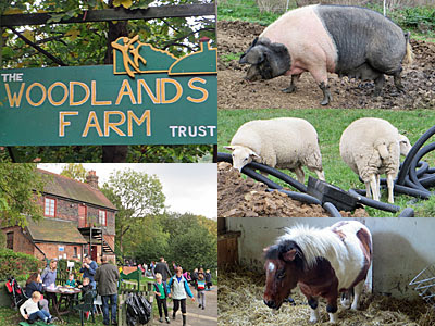
At the foot of Shooters Hill, opposite Oxleas Wood, lies Inner London's largest farm. Although run by volunteers it's a proper working farm, with acres of hayfields, orchards and animals, while school groups and other organisations are also welcomed. And half a dozen times a year they fling wide the gates and welcome in the wider community, including Mid-October for the Apple Fair, which was held yesterday. You could tell it was on because cars were parked the full length of the hill, making it difficult for buses to pass, such is the attraction of this family-friendly event. The event was delighting children of all ages, wandering through the farmyard to meet Bob the Shetland pony and Bella the saddleback pig, queueing for archery or gulping down candyfloss. They know how to pack out their sheds with stalls at Woodlands Farm, one with a timely focus on rare apples and crushed juice, another more artsy-craftsy. But in what looked like a classroom I was slightly unnerved when a man pressed into my hand a small advert for the farm's freezer-ready lamb, which I think I'd just seen gambolling in a pen outside.
As well as umpteen temporary goings-on it was good to poke around various back corners, like the hayfield and pond, to discover informative panels for educational use. But halfway up one lane a gate was firmly padlocked, a gate I recognised as a sore point of contention in a long-term access battle. The Green Chain footpath passes through the farm, or is supposed to, but Woodlands Farm contest that a right of way exists, citing vandalism on their premises as a reason to bar passage. The Inner London Ramblers insist the path through the meadow should be opened up (it's lovely, I walked it unfettered back in 2007), while the Trust remain vehemently against, and an angry stalemate continues. Should you want to explore the farm from the right side of the gate, the next similar extravaganza is the Christmas Fair on 6th December, or maybe you could just pop in for some eggs or kindling next time you're passing.
Week off (Sunday): Charlton Horn Fair
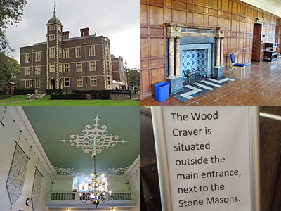
The last time I visited the Horn Fair at Charlton House it was a lively, outdoor summertime event. Yesterday the venue was the same but everything was more sedate, indoors, with a much more middling demographic, and bearing little resemblance to the 18th century cuckolds' carnival once deemed the bawdiest in London. The Horn Fair has been resurrected by the Royal Greenwich Heritage Trust to mark the Feast of St Luke, the event's traditional date, and they set about filling the building with activities with a historical slant. One target audience was children, with crafts, a treasure hunt and face painting scattered throughout, while adults were catered for with music and food and a roomful of talks spread across the day. In a cramped passageway by the toilets the Friends of Charlton House attempted to sell heritageworthy publications, upstairs in the Prince Henry Room a bewigged actor pretended to be a man of science, while out front a chirpy stonemason apprentice invited visitors to chisel their own reminder of the day.
It's not usually possible to explore this Jacobean mansion quite so widely, and for me the best part of the visit was finally getting the opportunity to roam within and admire its ceilings, fireplaces and panelled chambers. But I was also very taken by the postcard exhibition in the Long Gallery, lovingly curated by the lady standing alongside, opening up a snapshot of the era when stamped cardboard rectangles were the social media of their day. In one cabinet Annie's handwritten missives from Plumstead painted a verbal picture of Edwardian auntie/nephew chitchat, while another collection featured 'humorous' cartoons released as souvenirs of Woolwich Arsenal football club's weekly fixtures. The postcard exhibition is scheduled to remain open until Easter, whereas daily visitors don't generally get much further than the Mulberry Tearooms in the Minstrel Hall. A historic building with an oddly municipal feel, Charlton House isn't quite the draw it ought to be, but the Horn Fair (briefly) put that right.
Week off (Saturday): Chequers
When Autumn comes around, a stroll in the the Chilterns lifts the heart. And so I took BestMate out from Marylebone and showed him the undulating glories of the season. We strode along the Ridgeway from Princes Risborough to Wendover, a mighty fine seven mile walk atanytime of the year, and took in lungfuls of unpolluted air along the way. The first of two serious ascents came at Brush Hill, a steady climb that suddenly broke into a long flight of steps. This led to a splendid, if murky, panorama atop the cruciform chalk incision at Whiteleaf Cross, looking down across a flaming palette of leaves, ploughed fields and the occasional rooftop. For lunch we stopped at The Plough in Cadsden, notorious as the pub which David Cameron accidentally left his daughter at, and which displays a notice saying 'Warning No Children At The Bar'. This is a homely inn, all character and old brick, serving ales and proper food to a mixed clientèle of ramblers and local Telegraph readers. We plumped for the mixed ploughmans, a veritable banquet of cheeses and salad (BestMate took my orange, and I took his cucumber).
The Ridgeway skirts Pulpit Hill to the west, before reaching a fence labelled under Section 128 of the Serious organised Crime and Police Act 2005. This is the boundary of Chequers, the Prime Minister's Buckinghamshire bolthole, forcing a lengthy detour around the perimeter of the estate. As ramblers we were afforded an unexpectedly fine view of its lawn and smoking chimneys, so good that we assumed we must be being watched (and overheard) by MI5 via technology planted in the treeline alongside. Only at the point where the footpath actually crossed the PM's drive did we spot two very obvious cameras, a peculiarly British means of combining national security with the sheen of permissive freedom. On Chequers' far flank we tackled one more panting climb to enter the crunchy woodland atop the ridge. A long hump of green pasture rose up above a leeward swathe of amazingly fiery foliage, then stepping out onto Coombe Hill the entire Vale of Aylesbury spread out beneath us like a misty patchwork. "See, I told you it would be great," I said, before descending gently into Wendover for a hot cuppa. The photos: eight autumnal shades The walk: [map][directions][7 miles, about 3½ hours] The rail ticket: a return to Aylesbury does the trick [alight early, board late]
The ticket office at Bow Road station opened on 11th June 1902.
And closes on 18th October 2015. (at 3pm, if there's anybody left who'd like to use it)
Few will mourn its passing. You'll remember the huge hoohah when it was announced that all of the tube's ticket offices would be closing. But TfL have been busy closing ticket offices for months - steadily, sequentially, stealthily - and there's been almost no protest from the public. It can be a lot more hassle to queue at a machine than to speak to a human being, but passengers have generally coped, in the same way they've embraced self-service tills in supermarkets, hastening the advance of automation. The last ticket office closures will be in December - it's TfL's intention to shutter the lot by the end of the year - and today is the designated death date for Bow Road.
Bow Road ticket office opening hours
Mon-Fri
Sat
Sun
up until 2010
0600-1930
0700-2030
0930-1930
2011-2015
0700-1745
0900-1445
1000-1500
from tomorrow
closed
closed
closed
Several passengers do still use the facility. They wait in the morning rush hour to get their Oyster seen to, and stop by during the day to address some query of travel. Even I've had cause to step up in the last few weeks to get my Gold Card discount added to my travelcard - a process which the nice lady behind the counter assured me would eventually be possible at a machine. But more often than not the window is unused, revealing an Aladdin's cave of staff activity and operational notices in the tiny office behind. From tomorrow there'll be no requirement for anyone to sit inside, an act with potential implications for salaried personnel, as the machine age embraces this old Edwardian station.
At most stations TfL are plastering or tiling over the former interface between staff and public, a process they describe as "ticket hall improvement works". At West Ham they've pasted a vinyl graphic across the window recalling how Prince Charles rode in a train cab when the Jubilee line opened in 1979, while at Bromley-by-Bow the heritage anecdote relates to women's role as station staff during World War 2. At Waterloo and North Greenwich, what used to be ticket windows are now billboards exhorting passengers to ride the cablecar (while the cablecar retains two fully staffed ticket offices and an additional ticket booth at the top of North Greenwich's escalator). But Bow Road won't suffer quite so intrusive a fate because it's Grade II listed, hence any changes have to be more carefully considered... and hurrah for that, because some of the existing features are quite lovely.
Tfl had to seek planning permission for their upcoming alterations at Bow Road, as indeed they have to every time they tweak the ticket hall. Application PA/15/02274 was approved by Tower Hamlets last week, with seven supporting documents, and these confirm that reveal exactly what's intended to take place once "improvement works" begin.
• The ticket windows will be covered over with bespoke timber paneling to match the existing finishes.
The Design, Access and Heritage Statement finds no evidence that the hardwood paneling around the ticket office windows is original, indeed it appears to be relatively modern, say from the 1980s. Nevertheless we're going to get proper wood in front of our windows to maintain the illusion of heritage, and not a cablecar advert or some mention of Prince Charles, or worse.
• The ticket office window lights will have vinyl covers to cover any signage stating ‘ticket office’. Non-PVC film applied to both sides of existing cantilever light box, colour to match existing light box.
The best news is that the characterful lights above the ticket windows will be retained, at their somewhat jaunty angle, but with any wording thereon extinguished. It wouldn't be true to say Tickets any more, neither will these windows again provide Assistance. What's not yet known is where precisely in Bow Road's cramped ticket hall any future Assistance will be provided.
• Minor changes will be made to information provision.
I'm fascinated by TfL's definition of "minor". The planning application's before and after diagrams indicate that a significant number of information panels are being removed. These include the (empty) leaflet rack to the left of the main window and both poster frames beside the entrance ticket gate, essentially removing all paper-based information provision along this wall. Meanwhile on the opposite wall, between what used to be the newsagent's kiosk and the station entrance, three out of five poster frames are being removed, along with the existing tube map rack. All that will remain is a single Quad Royal frame (for a poster-sized tube map) and a leaflet rack, beneath a new white circle with a blue 'i' on it. This isn't a minor change, this is a cull, as the provision of information is slimmed down to the essentials.
Also being removed are the brass handrail by the ticket window (because nobody needs to steady themselves here any more), three Ticket Office Voice Transfer Units (because hard-of-hearing passengers will be able to speak directly to a member of staff) and the Chip and PIN reader on the counter (because technology outdates so quickly).
What remains to be seen is how staffing provision will adapt once the ticket office at Bow Road is closed. Because the station is legally deemed 'under ground', there's always been a member of staff in the ticket hall here, and presumably will continue to be. But they've always been located on the far side of the barriers, cut off from ticket purchase provision, so have never been the easiest people to talk to if you have an Oyster issue. Will they be expected to cross over to front of house more often, or permanently, or will an additional member of staff now be deployed? The ticket hall's so narrow that having someone standing around in front of the barriers would obstruct access, indeed the queue at the ticket window often did, and the queue at the ticket machines still does.
The passenger experience at Bromley-by-Bow, one stop down the line, suggests that TfL's commitment to improved staffing provision is a con. The ticket office here closed on 1st September, but there's been absolutely no attempt to push staff out into the ticket hall, or indeed maintain a significant staffing presence whatsoever. Figures released by the London Assembly this week reveal that Bromley-by-Bow's ticket barriers are left open over 50% of the time - the worst record on the tube network - due to absence of staff in the ticket hall. My experience suggests it's been this bad since at least 2011, and that the barriers are always wide open in the evening, should any fare-dodger fancy a free ride. There's no expectation that Bow Road will ever go the same way, but it's clear that the changes which begin tomorrow are more about efficiency than the provision of a customer-facing service.
Somewhat unexpectedly, the Night Tube has its own official website at nighttube.london. It's not aimed at you and me, it's aimed at TfL staff, seemingly as part of a drive to keep employees engaged. But it's beautifully designed, and very mobile-friendly, and packed full of information. Here are 20 facts about the Night Tube you might not have known.
1) "Becky, named after Harry Beck, the designer of the world famous Tube map, is the endearing owl which will appear on all signage and way finding to indicate Night Tube services." 2) When customers first enter a station, Night Tube maps and Night Tube pocket Tube maps will be available. A step-free guide to Night Tube will be provided (separately) for passengers with restricted mobility. 3) Ticket halls in the vast majority of stations served by Night Tube will display either the new Night Tube map or a smaller adapted ‘night’ version. 4) A typical tube carriage contains 12 car line diagrams. A proportion of these diagrams will become "a distinct, yet discreet, Night Tube version with a similar look and feel to the Night Tube maps." 5) Signage at station exits may be changed "to move the flow of customers in the safest and most efficient way" overnight. 6) With the launch of Night Tube, stations will move to a standardised travel day which starts at 04:30 and finishes at 04:29 the following day. If you have a paper ticket it will expire at 04:29 (but if you've already started your Night Tube journey by then, that's fine). 7) A team of Customer Experience testers has been out overnight with Oyster cards and contactless payment cards, touching in and out to simulate different journeys, to test out necessary upgrades to the ticketing system. 8) There are currently no plans for Revenue Control Inspectors to patrol the network overnight, but this will be "under constant revision". 9) More than 100 police officers will be out on visible patrol across the Night Tube network, including a permanent presence at key stations. 10) Over 13,000 CCTV cameras will be watching the Night Tube (which'll either make you feel reassuringly safe or wildly over-scrutinised). For example, Stanmore has 62 CCTV cameras, Camden Town has 75, Shepherd's Bush has 91 and Leicester Square has 117. 11) To limit the number of trains taken out of service, cleaning teams will be strategically placed along Night Tube lines, or on call, to intercept trains where a spillage has occurred so that they can board and clean these on the move. 12) No routine announcements will be made overnight at stations located above ground level, where there is the potential for householders to be disturbed. Where these stations still have older information systems which do not tell customers when the next train is due, "station staff will need to add manual information to the system." 13) At interchange stations which serve fewer lines overnight than during the day, announcements are likely to be made for the first few months after launch, explaining details to customers. 14) On every Night Tube line (apart from the Central), onboard automated announcements will be amended "to ensure customers are not needlessly confused by being told about lines that are not operating." 15) Twenty new Night Bus services will operate, but there will be fewer extra buses at weekends on 15 routes. 16) North Greenwich, Vauxhall, Canada Water, Stratford and London Bridge bus stations will be staffed 24 hours a day (in addition to those bus stations which already are). 17) After Night Tube begins, "maintenance schedules will make much better use of Sunday evenings than they do presently." 18) It was never planned to run the Night Tube on Boxing Day this year (even though it's a Saturday). 19) "There is very little or no evidence of demand for travel on the Emirates Airline routes overnight. However, we will continue to review the changes in our customers travel patterns after we start running Night Tube and respond to our customer's needs if the situation alters." (I love the apostrophe there) 20) The Night Tube marketing campaign begins on 22 July, and Night Tube begins on 12 September (ah, so the website's more than a bit out of date).
Especially for Bert and Jane, here's an update on Bus Stop M at Bow Church.
Some digital fixing has been going on behind the scenes. I'll try to keep this simple.
Wrong on Wednesday: 1) List of departures at Bus Stop M fails to include route 25 [ALMOST FIXED]
If you use an app or the TfL website, or if you text '55457' to 87287, route 25 now appears on the list of departures. This means it is now possible to check when the next number 25 bus is due. However, route 25 does not yet appear in the list of routes serving stop M, which still reads '8 276 425 488 D8 N205'.
Wrong on Wednesday: 2) Location coordinates for Bus Stop M incorrect [FIXED]
Bus Stop M's digital location has been updated from where it used to be (down by the flyover) to where it is now (opposite the church). This means electronic timings from the stop now match reality. If Bus Stop M had a Countdown display (which it doesn't), this would now show a correct list of departures.
Wrong on Wednesday: 3) Timetables displayed at Bus Stop M not quite correct [NOT FIXED]
All paper timetables remain those which were on display when the bus stop was located a minute down the road. Timings (and route diagrams) have not been updated to match the new location. It's highly unlikely that any passenger has noticed, been inconvenienced or cares.
Wrong on Wednesday: 4) Mismatch between name displayed at stop and digital name [NOT FIXED]
The name on the bus stop is 'Bow Church', but the digital name is still 'Bow Flyover', which was the name of the old stop down the road.
Wrong on Wednesday: 5) Buses approaching Bus Stop M display an incorrect next stop. [IMPROVED, BUT NOT FIXED]
Until yesterday, buses on route 25 displayed a next stop of 'Warton Road' (1km down the road). From yesterday (as a result of '1'), buses on route 25 now display 'Bow Flyover', the same as all other buses. Unfortunately (because of '4') they should be should be displaying 'Bow Church'. So we're not there yet.
Mystery on Wednesday: 6) Bus Stop M displays a tile for route 205 [STILL A MYSTERY]
I haven't mentioned this before, and it's not really a problem because the tile says 'Alighting point only'. But why did somebody decide to add a tile for route 205 when route 205 doesn't terminate here, and never has?
When you're alone and life is making you lonely
You can always go Midtown
Once you've done Soho and experienced Noho
Come and say hello Midtown
Just listen to the buzzing of the business in the district
Linger in the centre where the outlook's optimistic
How can you lose?
The brands are more vibrant there
You can leverage your lifestyle, indulge your affairs
So go Midtown
Things will be ace when you're Midtown
No finer hub for sure Midtown
Networking's waiting for you
Run by committee and it's west of the City
There are shops and shows Midtown
Maybe you know some boutique hotels to go to
Where the hipsters doze Midtown
Just pop down to the half mile that's a synergy of pleasure
You'll be mixing work and play - dream destination 'bleisure'
Happy again.
The hype is much brighter here
You can embrace innovation, upsell your career
So go Midtown
Where business rates are high Midtown
Plugged into free wi-fi Midtown
You're gonna really fly now
Midtown
Midtown
Midtown
And you may find a swagger here of fresh dynamic thinking
Integrate with companies like Google, DreamWorks, LinkedIn
They can't be wrong.
So maybe you'll join with me
We can reject all the old names, forget pedigree
And say 'Midtown'
Things never grate when you're Midtown
No finer brand for sure Midtown
Marketing's winning for you
Bloomsbury
St Giles
Holborn
Midtown
Midtown
Midtown...
As the Night Tube hits the buffers, with management and unions unable to agree staffing, you might imagine the entire project's gone quiet. Not so. TfL are already making changes to infrastructure, a little later than planned, to ensure that the underground network is Night-Tube-ready (whenever that might be).
He's the Night Tube Owl, the chosen symbol of this flagship project, whose appearance will signal the existence of very late trains on Friday and Saturday nights. As far as I'm aware the owl doesn't have a name, although I bet he'll get one (and please let it not be Boris) (and maybe it's a she, who knows). Note how his eyes are interchange symbols from the tube map, and his nose is the dot on a letter 'i' in New Johnston font.
A few stations have already been emblazoned with Night Tube signage, if you know where to look, for example here at Euston.
The owl appears on signs directing you to the platform, to make it really clear which lines are served by overnight trains and which aren't. During the day the owls will be unnecessary, so it's good to see they're not over-intrusive. But should you be wandering Euston station at 3am, Wotsisname the Owl will show you precisely where to go.
It'll also be very obvious where not to go. The Bank branch of the Northern line won't be getting overnight trains, for example, so the words "No Night Tube service" have been appended to directional signs at Euston to remind early morning passengers to stay away. Presumably a crossed-out owl was deemed inappropriate.
And somebody's really thought about the minutiae of this. For most of the day the Night Tube is irrelevant, but around midnight a transition takes place, and passengers need to know precisely when that is. Hence the appearance of a sign at Euston which states very clearly that the last train on the Bank branch is at 0028, and after that you'll need to take an alternative Night Tube route.
There'll also be physical objects to bar your way. Keep an eye out around the network and you'll start to spot gates being erected to seal off non-Night Tube lines, because TfL don't want you wandering onto the wrong platform in the early hours. For example, here's a gate at Baker Street to block off the Metropolitan from the Jubilee, and here's a gate at Earl's Court to stop you venturing up to the District from the Piccadilly.
Meanwhile the outer reaches of the Jubilee line have also seen an invasion of owls, as in this example at Finchley Road.
The Night Tube Owl appears in a strip across the bottom of the line diagram on each Jubilee line platform (but not on the adjacent Metropolitan, because that won't have a Night Tube service). I've checked out every Jubilee line station between Baker Street and Wembley Park and spotted the owl at each, and also at Bond Street, but not (as yet) at Baker Street itself. Here's West Hampstead, for example, and here's the same at Neasden. The thin blue strip isn't too intrusive, but is still sufficiently clear to ensure that overnight journeys can be made with confidence.
Here's what the bottom of each sign looks like close up (this example at Swiss Cottage).
Which is odd, because the text beside the owl is currently a lie. The Night Tube does not currently operate on Friday and Saturday nights on the Jubilee line, neither is this expected for the foreseeable future. Somebody really has jumped the gun here, potentially tricking passengers into turning up at the weekend and... oh, damn, it's shut.
This outbreak of Night Tube signage looks to be wifully premature, possibly by several months, and will be a daily reminder to Londoners of a service they haven't yet got. But it's good to see evidence that the eventual rollout of owls across the network will be practical and understated, even downright cute.
Update: Night Tube Owl seems to have two names. Internally, London Underground are using 'Becky', while the London Transport Museum are using 'Tooting'.
This is yet another post about three bus stops on Bow Road...
...becoming one.
Last week the last remains of Old Bus Stop E were removed, and this week Old Bus Stop M's gone the same way.
With both superfluous bus shelters removed, only one bus stop remains, and passengers cannot possibly be confused as to where to wait. And wait in the right place they do, so that's no longer the issue. The issue remains what the one remaining bus stop is called.
We now know for definite what the new bus stop is called, because yesterday TfL updated their consultation on diverting route 25 permanently over the flyover. They added a big extra chunk of text at the top, confirming that Old Bus Stops E and M are dead and Old Bus Stop G is indeed new Bus Stop M, and extended the consultation's closing date by a fortnight.
Nothing changes the proposals for route 25, whose permanent diversion will still go ahead, indeed is already in place and has been since March. Closing one bus stop and renaming another doesn't materially change the outcome of the consultation at all. But that renaming continues to be only skin deep, in a way which does affect passengers on route 25 and will continue to do so until fixed.
Nobody on the ground gives a damn about the letter stuck on top of the bus stop pole. The fact this bus stop used to say G but now says M is irrelevant to passengers waiting for a bus. The fact that the bus stop two hundred metres down the road used to be called M, and now this stop is, is also irrelevant. The fact that all bus stop M's timetables are one minute out, because they've been physically relocated from the flyover, is of no interest whatsoever. Everyone just gets on the bus when it comes, and everything's much as before.
But the electronic systems underlying the re-designation are bust. The entire switcheroo was most probably based on the idea that moving bus stop pole M up the road provided the simplest underlying digital transition, but things haven't quite worked out like that.
To explain, I need to list what the iBus system has been saying about each of the three bus stops during the transition period. Starting back in January when everything was normal.
January 2015
ID
Location
Routes stopping
Old Bus Stop E
50834
Bow Church
8, 488
Old Bus Stop G
77309
Bow Church
25, 276, 425, D8, N205
Old Bus Stop M
55457
Bow Flyover
8, 25, 276, 425, 488, D8, N205
For example, an eastbound number 25 bus would have stopped first at stop G (by the church), then at stop M (by the flyover), then continued round the roundabout. If only this had stayed the case, we'd have no issues today.
But instead in the spring it was decided to divert route 25 across the flyover, to catch up time lost to Cycle Superhighway works back near Aldgate. This meant missing out stop M, so the iBus data ended up like this instead.
April 2015
ID
Location
Routes stopping
Old Bus Stop E
50834
Bow Church
8, 488
Old Bus Stop G
77309
Bow Church
25, 276, 425, D8, N205
Old Bus Stop M
55457
Bow Flyover
8, 276, 425, 488, D8, N205
Over the spring and summer each eastbound number 25 bus stopped only at stop G (by the church), then skipped stop M (by the flyover) before flying over the roundabout. If you asked the TfL website or an app for a list of departures at stop M, buses on route 25 never appeared - quite rightly, because they were no longer stopping.
Now let's jump ahead to this month. Old Bus Stop E is closed so TfL have deleted it from the database, and querying it now generates an empty list of departures. Old Bus Stop M also closed, but TfL didn't delete it from their database, they deleted old Bus Stop G instead. They could have chosen to add route 8 and route 488 to Bus Stop G and everything would have worked perfectly, but no. Instead they re-designated what had been G as M, because that looked like the least work, and transferred across the existing list of bus routes. But somebody forgot about the flyover diversion, and they've continued to forget about it for well over a week.
This is what the current real life situation is.
October 2015
ID
Location
Routes stopping
New Bus Stop M
55457
Bow Church
8, 25, 276, 425, 488, D8, N205
But this is what TfL's database thinks it is.
October 2015
ID
Location
Routes stopping
New Bus Stop M
55457
Bow Flyover
8, 276, 425, 488, D8, N205
And now we have our disconnect.
So there are two main issues. The first issue is that, according to TfL's database, route 25 no longer stops at Bow Church, even though it does. If you get out your favourite app to see what's stopping here, it says the 25 isn't. If you text '55457' to 87287 you get back a list of departures in which the 25 does not appear. If you want to check when the next number 25 bus is due, you can't, and all because somebody chose to delete bus stop G rather than bus stop M.
And the second issue is that, if you're a passenger aboard a bus, the next stop appears wrongly named. Approaching Bow Church on a 276 or 425 you ought to see 'Bow Church' on the electronic display, but you don't, you see 'Bow Flyover' instead. The iBus system remembers what Old Bus Stop M was called, which is not what New Bus Stop M ought to be called, so flashes up the wrong name instead.
And these two issues combine in one glorious failure if you try to ride a 25 bus eastbound along Bow Road. If you get on at Bow Church DLR station then the list of consecutive stops ought to read as follows...
Bow Church Station
Bow Church (whizz across the flyover) Warton Road
But TfL's database no longer includes a stop at 'Bow Church', only at 'Bow Flyover', where the 25 (as you'll remember) doesn't stop. So the onboard display thinks the stops are...
Bow Church Station (whizz across the flyover) Warton Road
which is just plain wrong. If you board a 25 at Bow Church station the next stop is now given as 'Warton Road', which is three quarters of mile distant, even though the bus will in fact be stopping at Bow Church inbetween. Passengers on board hoping to alight must be mystified by the error. I could add to the confusion by pointing out that Warton Road is also designated Bus Stop M, which means there are two consecutive stops with the same letter, but that'd be a mere sideshow, so probably best I don't.
TfL appear to be intent on calling Old Bus Stop G New Bus Stop M, despite the electronic balls-up this redesignation has wrought. In which case all somebody needs to do is a) rename the stop 'Bow Church' instead of 'Bow Flyover' b) add the 25 to the list of buses that stop here. In an organisation that prides itself on agiledigital development, how difficult could that be?
I have my fingers crossed. I mean, imagine how nice it would be to fire up this blog in the morning without the fear I might have written about those bloody Bow Road bus stops again.
WALK LONDON The London Loop[section 24]
Rainham to Purfleet (5 miles)
If you ever decide to walk the London Loop, the capital's outer strategic walk, section 24's where you'll end up. A bleak stretch of estuarine footpath, far beyond where settlement stops, through what might be the most un-London-like landscape in London. Even if you decide not to walk the whole circuit, these last five miles make for a memorable couple of hours, plus it's quite flat, and there's a station at both ends so the whole thing's easily accessible. I combined my walk with a trip to Rainham Hall at the beginning, and the Rainham Marshes RSPB reserve at the end, to make the day even more special. [map][10 photos]
Rainham's still ostensibly a village, not quite swallowed into the Hornchurch sprawl. It also has the last shops, pubs and houses you'll be passing for the next five miles, so best stock up now on anything you might need. The area around the station's had a bit of a facelift of late, coinciding with the construction of a new flat-topped library which looks as yet out of place. Some elegant signage directs walkers and cyclists north along the Ingrebourne Way (Loop 23) or southeast to Purfleet (Loop 24), without ever hinting at the desolation that lies ahead. It used to be a simple walk down Ferry Lane from the station, until they built the High Speed Chunnel Rail Link as a barrier. Now it's up and over a twisty bridge, beside a row of vividly coloured sheds, to be deposited in the contour-free nomansland on the opposite side.
Rainham Marshes spread for miles along the Thames, broad and floodable, blighted by a row of pylons and a series of viaducts. In some parts grazing cattle roam, while others thrive with reedy vegetation, across the last remaining ancient wilderness in London. But here too is another East London landscape stalwart - riverside industrial - with an extensive chain of factories and warehouses bordering the last mile of the River Ingrebourne. It's not lovely. Thankfully the footpath veers along the edge of the marsh and then through it, pausing only to duck beneath the thundering A13. Havering Council have decorated the off-slip roundabouts with what look like giant upright hairbrushes, and which might just possibly illuminate after dark. And don't worry about getting lost, stencilled metal fingerposts will guide your way at every possible point of indecision, with confirmation posts every hundred metres - we're in elite waymarking territory here.
At the next turnoff, sorry, we're not heading the nice way. One path heads off into deep marsh lined by intermingled grasses, while the official Loop path aims for, and then between, the line of grubby warehouses. There is a reason for this, other than nobody bothering to update the route since the nicer path was laid, which becomes clear when you finally emerge onto a road beside the Thames. You may not notice the river at first, hidden behind a high concrete bank to protect against inundation, but clambering up top reveals a mighty wide river in grey low-slung glory. The flat panorama of manufacture and recycling, plus a lofty incinerator on the Bexley bank, is something you're going to have to get used to. Passing through on a Sunday the hum of commercial machinery was dormant, the only racket a lad on a small motorbike doing endless wheelies back and forth to inconvenience nobody.
Just when an inland diversion looks inevitable, the Loop nips out along the river wall between a line of tall silos and a working pier. As five large letters confirm, this is the Tilda rice factory, manufacturers of the UK's best selling basmati rice, perched here on the most distant edge of the conurbation. But it's swiftly forgotten, because there's proper history beached on the foreshore ahead. These are Rainham's concretebarges, constructed during the war when building materials were scarce, and used on D-Day as part of the Mulberry harbours. A decade later they were dumped here in the Thames as protection from the great flood of 1953. And here they remain, sunk into a beach at a variety of angles, slowly not-rusting away. If the tide's low and your footwear's appropriate then you might consider trudging out across the squelchy grass to stand alongside, but I'd recommend not, best leave the crew of pigeons to roost in peace.
And that's not all that's peculiar around here. A short distance away, anchored eight metres down into the riverbed, is a twisted mass of galvanised steel in humanoid form. This is The Diver, a submersible artwork, and allegedly the only sculpture to be located actually in the River Thames. It was installed here overnight in the year 2000 by artist John Kaufman, and dedicated to his grandfather who used to be a diver in the old London Docks. Come atlow tide and the entire sculpture stands proud above water level, but as the Thames slowly rises so the diver starts to vanish, until at certain spring tides each year the top of the helmet is fully submerged. It's a lovely idea, well delivered, and at such a remote location that only those in the know ever come visiting.
And if you thought that was bleak, keep going. A triangular expanse that used to be two riverside farms has been swallowed up over the last century by London's landfill, and a vast pile of rubbish has grown up to hillock heights. 2000 tonnes of fresh rubbish arrive by river each weekday, unloaded at a huge warehouse on a pontoon before being unceremoniously added to the working half of the site. Much of the rest of the Rainham Integrated Waste Management Facility has been sown with grass seed and will one day be a country park, although the plastic pipes sprouting from the hillside for ventilation purposes suggest that safe public access may still be some time off. Meanwhile the Loop continues around the headland towards Coldharbour Point, possibly the remotest spot within the Greater London boundary, and still the location of a squat red lighthouse (placed here for bend-turning navigational reasons). Several centuries ago a ferry crossed the Thames here to the town of Erith, its flats and houses now clearly visible on the opposite shore, but now reachable only via the lofty bridge that's just come into view on the horizon.
Passing portakabins and piles of pallets, the next section of riverside path is less than a decade old, permitting passage through to Purfleet. It smells a bit too. A fenced-off road allows Veolia staff in and out of the landfill dump, broken at one point by a deliberate gap in the fence. It would be easy to mistake this for a public footpath, the illusion strengthened by a humped zebra-style crossing and road signs warning drivers to slow for pedestrians. And that track winding its way up the hill beyond looks official, properly fenced on both sides to prevent access to the wider site, so you might indeed be tempted to follow. And once ascended to the summit, 25 metres being an unnaturally rare height in this corner of East London, you might gasp at the glorious panorama below, as the Thames sweeps round Crayford Ness past hundreds of acres of lush marshland, and the occasional Eurostar train flashes across the Aveley Viaduct. Indeed you might concur that when this rubbish dump is finally given back to the public as a public park, this viewpoint will become a must-see. But don't be tempted, there's as yet no evidence that the spiralling ascent is kosher, and who'd want to encroach illicitly?
The final remote stretch of this walk begins at a wholly unexpected car park and continues alongside Aveley Bay, finally crossing from Greater London into Thurrock. Officially the path follows the tarmac track beneath the river wall, but feel free to walk up top for an unshielded view because the metal gates at each end are probably unlocked. The low wetland to the north belongs to the RSPB, it's their Rainham Marshes reserve, and the peculiar brown-striped building in the distance is their visitor centre. You'll need to get that far before you can gain access, but I can heartily recommend you do, and if you want to fit in make sure you bring binoculars with you. The network of boardwalks, hides and reedy scrapes on this former MoD rifle range provide an ideal location for monitoring waders and waterfowl, and if you're feeling particularly fit you should add on the full 2½ mile circuit around the perimeter. If nothing else it'll delay your arrival in the letdown that is Purfleet.
Once across the Mar Dyke the houses begin, not the finest in the property portfolio, their cheery inhabitants perhaps spilling out onto the grassy promenade. Come on the right day and the bricked-up gunpowder store housing the Purfleet Heritage and Military Centre might be open, mistime and you might have to step out of the way to avoid being mown down by a teenage girl on a quad bike. And whilst you'd hope the end of the 150 mile Loop would be marked by something special, there's not even a sign, and the official exhortation to pop into The Royal Inn for a celebratory pint couldn't tempt me across its tattooed portal. Instead I strode on to the station, determined to catch the hourly train, after what had been a fabulously stark and wide-skied walk.
And if walking takes your fancy, be aware that this weekend Walk London are organising forty free guided walks across the capital, about a third of which are decent hikes like this one. Under the umbrella of Autumn Ambles, they come highly recommended.
The National Trust run only a dozen properties in London, and not always in the most likely locations. One of these reopened last week after a lengthy restoration, in a large village on the Thames Marshes in deepest Havering. It's Rainham Hall, a particularly fine example of a Queen Anne house, and £1.5m has brought it back to life in a community-tastic manner.
Rainham Hall was built in 1729 by Captain John Harle, a seafaring merchant from County Durham who married an East End lass. He bought up the local wharf, then connected to the Thames by creek, and used it successfully as a base for trade. His house was upwardly mobile but not upper class, hence not the National Trust's typical stately home, and all the better for it. Three storeys tall, plus basement, its square frontage stands proudly (behind particularly ornate iron railings) beside the parish church as befits its local status. Plus outside there's an orchard, plus private gardens, plus public gardens, plus a stable block, plus a giant Victorian dog kennel - at least one of which houses the new cafe. So it's a winner, obviously.
I'd been to Rainham Hall before, back in 2011 when it was open only intermittently and awaiting a much-needed injection of cash. In those days a guide took a small group round, apologising for the fabric of the interior and pointing out aspects of interest. In the refurbished building the emphasis is different, as the National Trust branches out and tries a rather different approach. Now you're allowed to wander round unbidden, and the focus has switched from the building itself to its inhabitants. A wide cast of characters has lived at Rainham Hall over three centuries, and the NT proposes to focus on a different resident in turn, each for a year or so, in an attempt to bring their story to life. In the future we're promised an insight into a 18th century Methodist preacher, a postwar nursery child and a photographer for Vogue. But first out of the personality brantub, and rightly so, is the Hall's first owner, John Harle.
John's bewigged wife was waiting at the front door when I arrived. This may have been an opening weekend special, or it might be normal, it's hard to tell. My visit on Sunday coincided with a community fete designed to welcome those who live nearby and help make them feel part of the project. Rainham Hall was thus teeming with people, a wholly atypical experience hereabouts, but which'll have delighted the general manager sitting out back on a sunny bench. If you visit you'll be able to explore three floors but we were only allowed two, the attic floor being too weak to support a torrent of freeloaders. But you might also miss the animated atmosphere, and a sense of collective exploration, as the over-50s of almost-Essex swarmed all over, and enjoyed.
The most impressive room is the entrance hall - as would have been expected in the first area seen by guests - dark and wood-panelled with a coat of arms above the fireplace. There are then three ground floor rooms to explore, the idea being that if you see a door you open it, and who knows what surprise you might find behind. For example nobody'll be expecting one room to contain nothing but a video of the rolling sea projected onto all four walls (won't be expecting unless they've read this sentence, sorry). The front room houses a board game played with gloves inside a perspex box, this because the counters are actual 18th century coins, though I fear the rules are too complex for the average visitor to want to engage. Meanwhile out back is the kitchen, the ideal blank canvas for historical invention. For this opening exhibition it's become a Lloyd's Coffeehouse, as merchant Harle would have been a regular visitor, with fact-packed freesheet to read or take away.
Upstairs follows the same minimalist pattern, one concept per room. John's wife is imagined through what might have been her wedding dress. John's trade is celebrated in a cabinet of splendid shiny seafaring equipment loaned by the National Maritime Museum. A front room contains nothing but a table to practice Georgian handwriting, spurred on by the Great Vowel Shift John would have experienced in his journey south. The bath has been filled, somewhat playfully, with solid blue water and a fleet of ships. And then there's the house's pride and joy, an artefact by rights it shouldn't own, namely John Harle's will. This was discovered completely by chance by Rainham's postmistress, stopping off at a car boot sale half way up the A1, and her tale is engagingly told behind the sealed vellum she donated.
I liked the garden, especially the long herringbone path leading directly from the back door. Out back, on a long terrace, the house's orchard is currently dripping with apples and sweet-smelling pears. And you won't get this, but on Sunday a handful of stalls were laid out across the lower public garden, the lady from local hospital radio clearly wishing she'd set up her fleamarket closer to the path. Other stallholders had taken over the top floor of the stable block, including a representative of thecraftgroup commissioned to sew something appropriate for each regeneration of the hall's display (for example a Delft tile, to match the rare ones in the fireplace). And the stable block is also where you'll find the cafe, doing a roaring trade on my visit, as an army of volunteers got to grips with how precisely the till and (more importantly) the milk frothing machine worked.
The cafe's going to be open daily, with the upstairs space available for community groups, which sounds like an excellent local resource. The Hall will be open every day except Monday and Tuesday, so don't head there today, and avoid Wednesdays and Thursdays too once the winter season kicks in. But that's still hugely more accessible than "the occasional Saturday afternoon", which was the building's previous fate, as befits the impressive transformation wrought beneath its roof. I'm not entirely won over by the focus on characters at the expense of architecture, and some of the minimalist displays underwhelmed, but the fine detail is excellent, and the chance to tell a variety of stories over the forthcoming years is an inspiring idea. And Rainham Hall's a really easy walk from the station, and only two stops past Barking, assuming you've never been out this way before.
Last month there were three bus stops along my local bit of Bow Road.
Now there's only one.
Thanks cyclists, you did this.
Old Bus Stop M was incompatible with the Cycle Superhighway, blocking access to the segregated lane immediately before the Bow Roundabout, so had to die. Only the shelter now remains, barriered off and awaiting removal. Anyone who used to catch the bus here now has to walk 200 yards up the road to catch a bus, which is hardly the end of the world, but annoying all the same.
Bus Stop E was also incompatible with the Cycle Superhighway, there being insufficient space behind to carve a bus stop bypass, so had to die. On Wednesday the bus shelter was surrounded by barriers, but on Friday it was removed altogether. Workmen moved in to wrest it from the pavement, making good the paving slabs in its wake, and creating ample space for pedestrians for the first time in years. So thorough was their work that there's now no clue that a bus stop was ever here... apart from the words BUS STOP written in the road, and that won't last long once the Cycle Superhighway drives through.
Which would be the end of the story, indeed for passengers turning up to catch a bus it is. They all now head for New Bus Stop M, on the site of Old Bus Stop G, and nobody waits at Old Bus Stop E at all. But one outstanding issue remains, which is that the electronic information regarding New Bus Stop M is incorrect, and all because somebody took a cheeky administrative shortcut behind the scenes.
To explain the mess I need to go back a year. Back then every bus stopped at either Stop E or Stop G, and then every bus stopped at Stop M. Here's a list.
Old Bus Stop E (Bow Church): 8, 488 Old Bus Stop G (Bow Church): 25, 276, 425, D8, N205 Old Bus Stop M (Bow Flyover): 8, 25, 276, 425, 488, D8, N205
Today there's only one bus stop, and every bus stops at it. So it must have made sense to somebody somewhere to hang on to that bus stop, and its letter, and its timetables, and shift it 200 metres up the road.
New Bus Stop M (Bow Church): 8, 25, 276, 425, 488, D8, N205
Contractors were ordered to rip out the bus stop pole by the flyover and reinstate it by the church, remembering to change the nameplate (from Bow Flyover to Bow Church) in the process. None of the route number plates or timetables would need changing, and all the electronic "next bus" jiggery pokery would work too - it should have been the perfect easy option. Apart from three things.
Firstly, buses reach New Bus Stop M a minute earlier than they reached Old Bus Stop M. This means all the timetables are wrong, both at the stop and online, because nobody's bothered to adjust them. They're only a minute out, which you'd think ought to be no big deal. But this means app users who turn up when a bus is "due" will actually have missed it, because it'll already be a minute down the road. And there are accurate timetables, I know, because they were posted up at Bus Stop G when it stood in precisely the same spot in August. In a world of accurate data this smacks of slapdash inconsistency.
Secondly, if you're on board any bus heading east, the electronic display shows the wrong name for the stop. It should say 'Bow Church', but instead it says 'Bow Flyover', because that's the name in the database associated with the bus stop lettered M. This too suggests that somebody behind the scenes hasn't completed all the digital changes associated with the switchover.
Thirdly, and more awkwardly, route 25 stopped stopping at Old Bus Stop M back in March. TfL rerouted the 25 over the flyover to speed up the service, skipping Old Bus Stop M and the next bus stop on the other side of the roundabout in the process. They've since decided to make this rerouting permanent, and are currently running a box-ticking consultation to ensure this happens. But this diversion meant the list of bus routes stopping at Old Bus Stop M became one bus short, with the 25 deleted...
Old Bus Stop M (Bow Flyover): 8, 276, 425, 488, D8, N205
...and TfL's computer still thinks this is the case.
The 25 bus does stop at New Bus Stop M - it's the last stop before the flyover. But the 25 doesn't appear in the list of departures on TfL's webpage for Bus Stop M, even though all the other buses do. If you text '55457' to 87287 you get back a list of departures in which the 25 does not appear. In fact I believe it's impossible to get next bus information for route 25 at new Bus Stop M, whether you use the TfL website or an app, now that Bus Stops E and G have been electronicallyeliminated. And all because somebody somewhere decided it would be a smart idea to switch Old Bus Stop M 200 metres up the road, rather than retaining Bus Stop G and amending the routes served.
Nobody outside Bow cares, I know, but when you actually live here this stuff matters. It also matters that Old Bus Stop E used to have a Countdown display in its shelter, but new Bus Stop M doesn't, so the people of Bow Road are now making do with less information than they had before. And I haven't even started to tell you about the other problem with New Bus Stop M, namely the big gap in the middle. Once the lamppost stump is removed and the final barriers come down, I'll be back to tell all.

Especially for Bert and Jane, here's an update on Bus Stop M at Bow Church.