• several EU countries suspend use of Oxford jab
• Thorntons to close all its shops
• surge in UK vaccine supplies this week
• "continue using Oxford vaccine" (WHO)
• lockdown to ease in Scotland in late April
• over 50s invited to be vaccinated
• significant reduction in UK vaccine supply in April
• Paris enters month-long third wave lockdown
• EU resumes Oxford rollout after clot review
• PM gets his first Oxford jab
• summer holidays abroad 'extremely unlikely'
• Olympics will have no international tourists
Worldwide deaths: 2,640,000 → 2,700,000 Worldwide cases: 119,000,000 → 123,000,000 UK deaths: 125,464 → 126,122 UK cases: 4,253,820 → 4,291,271 Vaccinations: 23,684,103 → 26,853,407 FTSE: down 1% (6761 → 6708)
Beckton's not the nicest bit of Newham. Originally it was marshland, then in the 1860s it gained a massive sewage works and Europe's largest gasworks. The sewage works is still there, and the rest is now mostly 1980s/90s housing and several large retail parks. But one thing Beckton does have a lot of is footpaths, some long and secluded, others short and snickety, making it an intriguing place to walk around. Let's follow a few.
The path that used to be a sewer
Yes it's the Greenway, the sewertop path that runs from Hackney Wick to Beckton. A broad tarmac track edged by grass (and only occasionally whiffy), it's proved to be an ideal cross-borough connection for walking and cycling. It's busiest around Stratford, then calms down a bit east of Plaistow, but the final stretch in Beckton is easily the quietest of all. A giant roundabout on the A13 interrupts the flow, and the subsequent half mile of Greenway then leads nowhere special with no intermediate points of access. I usually think twice before daring myself to walk right to the end. [map]
The raised path passes the foot of Beckton Alp, a contaminated dry ski slope, then looks down over the backs of warehouses, B&Q and a giant Sainsbury's. At this time of year it's enlivened slightly by buds, blossom and birdsong, but nobody comes here because it's attractive. The isolation helps explain how I disturbed a rabbit which promptly hopped off the track and hid in some brambles, Near the end of the path comes a Britvic factory and a locked Thames Water rising main compound, plus one of the green metal gateways plonked here in the 90s. And then the Greenway stops abruptly because the public aren't allowed to walk the last few hundred yards into Beckton Sewage Works because obviously they're not.
The path that shadows a dual carriageway
Beckton's very much a suburb for people with cars, but the planners who designed the area threaded numerous footpaths all over the place to aid getting around on foot. Their admirable intention was to segregate pedestrians and vehicles but all too often the end result was a long secluded path shielded by woodland, so not somewhere everyone would feel safe. The sheltered path alongside Royal Docks Road is a case in point, running almost uninterrupted from Beckton Triangle Retail Park to Woolwich Manor Way. The first stretch at least shadows a car park, but that just means it's littered with fried chicken packaging and drive-thru coffee cups. You might find yourself sharing the path with someone lugging their shopping home in a rucksack, but more likely you'll be here entirely alone. [map]
The first access point is the end of the Greenway, which is bugger all use as a potential escape route. The big Tesco at Gallions Reach is very close but what looks like an access point under the viaduct peters out amid grubby undergrowth. Beyond Britvic the dual carriageway finally re-emerges, then it's back into the trees at the end of Winsor Terrace and alongside the rear of a school playground. The DLR is down there somewhere but you can't see it, and they can't see you. And at the southern end is a swish spiral ramp laid with good intentions, but it lands on a slip road where pedestrians aren't officially allowed so you need to divert off early. Best not.
The path that follows a country lane
Once upon a time Gooseley Lane stretched out into the marshes from the southern tip of East Ham providing access to a few squidgy fields. And then the A13 got built across it, with the northern half embraced by a housing estate and the southern half by the Beckton Triangle Retail Park. The latter is a mass of big sheds and bigger car parks, a magnet for East London families in need of soft furnishings, bathroom fittings or electrical goods. And somehow the line of the old country lane has been preserved as a public footpath - as previously discussed one of only six public footpaths in the borough of Newham. [map]
It helps that the path follows a stream, although technically it's only a drain and a fairly runty one at that. It doesn't help that the water is littered with shopping trolleys - both Sainsbury's and Lidl - plus assorted paper and plastic gunk. Half the path skirts the rear of Dunelm and the other half squeezes between B&M and Harveys for the benefit of those attempting to reach the 173 bus stop or climb the A13 footbridge. It's not Beckton's most unpleasant footpath, there are numerous contenders for that crown, but it does feel like one of its most unnecessary.
The path that used to be a railway
Back when railways were built to places of work, not highrise apartment clusters, the industrial outpost of Beckton had its own branch line. It ran direct across the marshes from Custom House and dropped off passengers by the entrance to the gasworks. Occasional peak hour services ceased in 1940 and the last freight train ran in 1970 leaving a temptingly empty trackbed. It would have been an obvious route for the DLR's Beckton extension but that instead went the long way round via the Royal Docks before hooking back to serve the centre of the new estate. The very tip of the branch line was reused but the remaining mile got turned into a broad footpath called Beckton Corridor. [map]
The corridor begins between the Asda bus station and the undertakers, then ducks beneath the pylons to the southwest. The path is broad, attractively paved and well used, particularly by supermarket shoppers threading home. Partway along is a small nature reserve with over-decorated ponds which the local community has nicknamed Itchycoo Park. The former railway then breaks out across Beckton Park before diving back into woodland between cul-de-sacs and allotments. Here it changes its name to Jake Russell Walk, rounds a children's hospice with an enchanted forest in its back garden and follows one last mugger-friendly curve to Prince Regent DLR. If you're up for off-putting exploration on foot, Beckton has much to offer.
Following a wide-ranging review of public media services, it has been decided to relocate diamond geezer to the north of England.
Its core mission must be to deliver for the whole of the UK, so the blog will shift its creative and journalistic centre away from London to better reflect, represent and serve all parts of the country. This radical and ambitious change empowers a significant creative and journalistic rebalancing of the blog's footprint and will more effectively represent different voices and perspectives, covering the stories that matter most to audiences and reflecting the passions and identities of a culturally diverse UK.
Rather than focusing on the metropolitan elite, daily blogging will now be rooted in, and inspired by, the wider UK community.
diamond geezer is therefore to be uprooted to the North of England and a fresh base in the town of Rochdale. This key Pennine location is perfectly balanced for easy access to Yorkshire, Lancashire and the wider North West region while still within easy travelling distance of the West and East Midlands. Rochdale boasts excellent motorway and rail connections as well as its own tram terminus and a historic canal. With the cultural hubs of Greater Manchester and the Calder Valley on the doorstep, this relocation redefines diamond geezer as a genuinely UK-wide media presence.
Census to turn Rochdale landmarks purple
This weekend is a historic one, not just because it's census day but also because key landmarks across Rochdale will be turning purple. These include the bridge over the river Roch in the town centre, St Leonard’s Parish Church in Middleton and the Grade-I listed Rochdale Cenotaph. The idea is that Rochdaleans will notice the purple lighting and then, duly inspired, instinctively go home to complete their census declaration. Other national landmarks to change colour include Blackpool Tower and Guildford Castle, but Rochdale is having to make do with the best of what it has, Gracie Fields statue excepted.
Pete Benton, ONS director of census operations, said: "We wanted to shine a light on important local buildings and landmarks, highlighting the importance of the census in helping shape the communities we live in." He supposedly continued "We’re thrilled with the support we have received and thank the borough of Rochdale for their participation", confirming that marketing folk continue to put words in executives' mouths even 150 miles from the capital. When you see the pretty purple lights, remember to complete your decennial survey and help determine the future of the Rochdale community we live in.
Bakery chain Greggs opens unit at Rochdale Riverside
Lovers of vegan sausage rolls were left disappointed when Rochdale's newest shopping mall opened beside the tram terminus in April 2020. Not only did the onset of lockdown entirely mute the celebrations but the sole refreshment option at launch was M&S Food. It's since been joined by Heavenly Desserts, Crust and Loaded Burgers, but none of these do a decent tuna baguette or steak bake which means Greggs aficionados have been forced to continue to use the branch at Rochdale Exchange, the one watched over by Judith Bluck's three bronze sheep. So hurrah that a new Greggs has now opened at Rochdale Riverside in a 1000 sq.ft unit between Boots and the Reel cinema offering all the finest savoury treats. Indoor and outdoor seating will be made available as soon as the current lockdown eases.
Hourly trains will blight Smithy Bridge
During the last year we've all enjoyed essential exercise around HollingworthLake, the man-made reservoir that feeds the Rochdale Canal. The Victorians definitely knew what they were doing with those paddle steamers. But as travel restrictions ease there are fears that upcomingchanges to the rail timetable may relegate the local station to “insignificance” and could lead to an increase in car use, because Northern's spring timetable will see Calder Valley services at Smithy Bridge halved from half-hourly to hourly.
Richard Lysons, chair of the Friends of Littleborough Stations, said: "Smithy Bridge station should be a focus for people wanting to visit the local countryside, as well as using the train to go on shopping trips and days out. All that an hourly service will achieve is to encourage people to jump into their cars and drive to Rochdale station and catch a train or tram there, putting more vehicles on the town's congested roads."
Chris Jackson, regional director at Northern, said: "Though we will maintain a good service during the morning and evening peaks, I completely understand that one train per hour during off-peak may be frustrating for our customers. This is not a decision we took lightly and stakeholders were consulted. By carefully managing the services we operate we can better ensure a reliable and stable service for rail travellers across the north of England."
Green e-scooter trial to explode across Rochdale
Wow, it's just been announced that a trial e-scooter scheme will launch in Rochdale before the end of March. The green steeds of Lime, supported by Transport for Greater Manchester and the borough council, will start to litter the town centre within days. If the current trial in Salford is anything to go by, expect sustainable travel transformation. And if all goes well the scheme will be extended in phases to Heywood and Littleborough, potentially enabling leisure trips to Hollingworth Lake, although at 15p a minute it might be cheaper to take the hourly train. Get scooting!
Coming soon to diamond geezer (north)
» The Co-Op Pioneers (a 20 part series)
» Ellenroad Engine House Steam Museum
» Rochdale's Least Used Tram Stop
» Hooley Bridge to Crimble
» Mild Urbex - Trub roundabout (M62 J20)
» Secrets of Saddleworth Moor
» Is it possible to walk to Oldham?
» Waterloo Road - the filming locations
Today is my printer's 20th birthday.
I might celebrate with a glass of champagne, on the basis it's cheaper than the ink.
I bought it from Staples in Ipswich in March 2001. It replaced a black and white printer with a ribbon, and doubled up as a scanner which I thought might come in useful. It came recommended, which was good because I didn't want to end up with a duff plastic box sitting on the floor beside my computer. And it only cost £279, which I must have thought good value at the time despite the fact that 20 years later you can buy something better for a fraction of the price.
Initially it didn't work. After I'd unwrapped it and trailed the cable across the carpet an error message flashed up complaining about the cartridge which had come with the machine, so I had to go back to Staples and plead for another one. It then worked fine, my Hewlett Packard OfficeJet G55, and has continued to be a reliable accessory ever since. It's just a shame the same can't be said for the things plugged into it.
The first thing I did with my new printer was scan a cartoon in a newspaper in the hope of emailing the image to a friend. It was a faff orienting the newsprint and keeping it still while a bright light moved across the glass, then working out where the resulting image file had ended up and how to save it somewhere so I could upload it as an attachment. But I was terribly excited by all the possibilities that digitising words and pictures might offer - something we in the smartphone age now take totally for granted.
This was also my first dabble with colour printing, something that previously I could only have done on the special photocopier at work or by taking hard copy down to Prontaprint. I probably used this feature too often before I realised it made the tiny colour cartridge run out sooner, so switched to default black and white unless the context required it, and then to 'draft quality' to preserve monochrome stocks even further. Nothing made me cringe more than accidentally printing out an A4-sized black rectangle, except perhaps wasting multiple sheets of paper on unnecessary gibberish.
One of the things I used to print most often was maps. Initially I had to wrestle the relevant section of an OS Landranger onto the glass so that I could take a copy with me rather than the real thing. Then I worked out it was possible to print maps I didn't own off the internet and this was transformative in terms of going out exploring. A heck of a lot of my early blogging adventures only happened because I had a folded-up printout of an unfamiliar neighbourhood in my pocket.
"Print this out and bring it with you" was a staple instruction for much of the last 20 years. Receipts, tickets, airline gate passes... all sorts of events and journeys relied on my printer spewing out a sheet of paper. Other useful lifestyle functions included 'copying old photos', 'downloading a leaflet' and 'sending a letter' (neatly signed at the bottom in fountain pen). I'm not quite sure when printers had their heyday but 2001 probably falls within the timespan and 2021 probably doesn't.
Things started going wrong for me when I was forced to upgrade to a new computer. My 2006 upgrade was fine because the printer driver on the original CD-ROM worked fine. My 2009 upgrade was fine because although the original printer driver no longer worked, a new one automatically downloaded when I plugged it in. But when I tried the same trick in 2015, sorry, no compatible printer driver was available. Fourteen year-old printers aren't readily supported when the manufacturers would rather you bought a new model, dammit.
I soon worked out I could use my home network to transfer files from my 2015 laptop to my 2009 laptop and print things out from there. This ruse immediately extended my printer's life, and my good old G55 struggled on. Alas my 2009 laptop is now somewhat temperamental so can't be relied upon, plus the last time I used my printer the ink showed every sign of running out. I didn't want to fork out for a new cartridge I'd probably barely use before the entire system broke down, not given the extortionate cost of ink, so I've now stopped printing things altogether.
It hasn't been too bad. Nothing urgently needs printing. There haven't been any ticketed events to go to, and my smartphone generally doubles up there anyway. And even before lockdown my inability to transfer words and pictures to paper hadn't been a problem, merely a minor limitation. I know that if I had a functioning printer I'd definitely use it, but I don't and I now know I can do without.
You might be thinking I'm missing out. There are so many creative things a printer can do, so many avenues that being printerless closes off. You might not be able to get by without one, for example if home schooling has required the generation of reams of worksheets. Or you might be thinking yeah grandad, nobody needs a printer any more. Paper's old school now that everything works via a screen, indeed there's an entire younger generation who wouldn't dream of having a superfluous output gadget in the house.
I ought to dispose of my redundant printer now it no longer connects properly, or I should stop being stingy and buy another cartridge, or I should take the plunge and buy a decent modern replacement. I know the price of ink's extortionate, a means for the manufacturers to bleed us dry long-term, but by not having a printer I'm only limiting myself unnecessarily.
The trouble is I've learned to live without for so long that I suspect I could carry on living without permanently. And anyway, my 20 year-old printer still works perfectly, it's only the connections and the cartridge that are letting it down.
Between 1900 and 1965 the County of London contained 29 metropolitan boroughs. In 1965 these were reorganised, along with various Home Counties districts, to form the 33 current Greater London boroughs. The new boroughs mostly consisted of two or three of the old boroughs merged together. Several former boundaries disappeared as a result of these mergers, but only in a handful of cases did all three boundaries meeting at the same point vanish.
Tower Hamlets was formed from the three former boroughs of Bethnal Green, Stepney and Poplar. The point where the three met is significantly off-centre. It's not even on the edge of Bow, it's in the middle of a grid of Victorian streets between Roman Road and the railway. It would have looked a lot less odd when these were fields and it made sense to locate boundaries away from where people lived.
This street corner, where Lyal Road meets Stanfield Road, used to be in the borough of Bethnal Green. This was essentially the parish of St Matthew Bethnal Green as it had been in the 18th century, and before that it was the Hamlet of Bethnal Green because these have long been the Tower Hamlets. A map of the parish in 1848 confirms that this eastern end was pretty much undeveloped. The house on the corner was built in the 1870s. I had to wait for the lady in the house with the scaffolding to go out shopping before I dared take the photo. Bethnal Green: area 3.1 km², former population 47,000
This street corner, where Lyal Road meets Viking Close, used to be in the borough of Poplar. This was essentially the parishes of Bow, Bromley and Poplar bolted together, hence the borough's peculiar elongated shape. Poplar was so thin it didn't even make it all the way from the River Lea to the Regent's Canal, it petered out here along a former hedgerow. The shop on the corner was built in the 1870s but was converted into a house some years ago. I had to wait for a Sainsbury's delivery van to finish unloading before I dared take the photo. Poplar: area 9.5 km², former population 67,000
The opposite side of the crossroads, where Lyal Road continues, used to be in the borough of Stepney. Stepney's back history was a lot more complicated, formed from thirteen parishes including Christchurch Spitalfields, St Anne Limehouse, St John of Wapping, St Mary Whitechapel, Mile End Old Town and Mile End New Town. This particular patch of land derives from Mile EndNew Town, three fields back from the Mile End Road. The houses on both sides were built in the 1870s. I had to wait for an unfeasibly high number of schoolchildren to walk past before I dared take the photo. Stepney: area 7.2 km², former population 47,000
Until 1965 residents of these corner properties paid their taxes to three different authorities. Today it all goes to Tower Hamlets.
Viking Close wasn't always called Viking Close, it used to be a continuation of Stanfield Road before a line of bollards was added for traffic mitigation purposes. And the Bethnal Green/Poplar border didn't always run along the centre of Lyal Road, it ran down the backs of the gardens on the eastern side instead. Today a new building on Viking Close marks the previous triple point. Built into its wall are a pair of parish boundary markers from the 1880s, one chiselled with M.E.O.T. (Mile End Old Town) and the other St.M.S.B. (St Mary Stratford le Bow).
The only other points where three County of London boroughs merged to form a single Greater London borough were...
• the junction of Edgware Road and Oxford Street where Paddington, St Marylebone and Westminster merged to form Westminster.
• the junction of Albany Road and the Old Kent Road where Bermondsey, Camberwell and Southwark merged to form Southwark.
Camden and Hackney were also formed from three County of London boroughs, but neither has a single point where all three met.
Meanwhile there are four points, not originally in the County of London, where three boroughs merged to form an Outer London borough...
• Bush Hill Park Golf Club where Edmonton, Enfield and Southgate merged to form Enfield.
• the junction outside Turnpike Lane station where Hornsey, Tottenham and Wood Green merged to form Haringey.
• Lower Marsh Lane near Surbiton Cemetery where Kingston, Malden & Coombe and Surbiton merged to form Kingston.
• the junction outside Sainsbury's in Colliers Wood where Mitcham, Merton & Morden and Wimbledon merged to form Merton.
Barnet, Bexley, Bromley and Hillingdon were formed from more than three boroughs, but what would be the point?
My twelfth random ward is essentially a ring around St Paul's, but not the cathedral itself. It used to be based around Bread Street, the City's medieval bread market, but that's recently been relegated to the eastern edge following a series of boundary changes which confirmed the City has no truck with administrative heritage. Pretty much the entire ward was destroyed in the Blitz, so this'll mostly be a tour of what they replaced what they replaced it with. [pdf map][10 photos]
St Paul's Cathedral is the elephant in the room, always visible but never to be mentioned. Here's the iconic view up Peter's Hill, which lies within the ward, although the interesting buildings on the left aren't and neither is the big dome at the end. Bread Street also includes the skateboarders enjoying the cascade of steps, the Firefighters Memorial at the top of the slope and the spiky City of London Information Centre just round the corner. Looking through its locked doors I spied a red bus fridge magnet, a rubber duck dressed as William Shakespeare and a copy of the Brighton Food and Drink Guide 2019/2020.
The ward can't claim Temple Bar as its own because it started life elsewhere, but it lives here now. This ceremonial gateway was removed from Fleet Street in 1878 having become a significant barrier to traffic, and then spent over a century decaying on a Hertfordshire estate. It was only brought back in 2003, stone by stone, to fill a gap between an outdoor clothing shop and a rare set of public conveniences. The Corporation of London reappropriated it as a heritage gateway to the new PaternosterSquare development, a classical vision badly in need of something old.
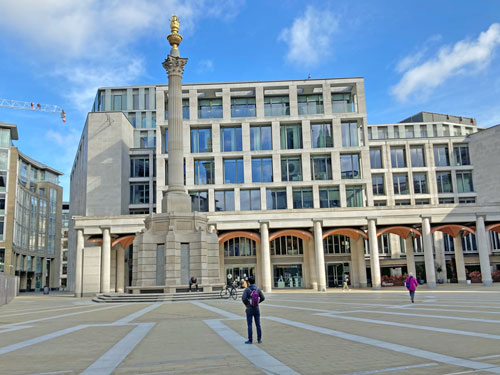
A large area north of St Paul's Cathedral was razed in the '40s, rebuilt in the '60s and generally hated by the '70s, so architects decided to have another go in the '90s. They focused the new commercial zone around a continental piazza with radiant paving and added colonnaded offices on three sides. The centrepiece is a Corinthian column topped by a flaming copper urn, a flourish which it turns out is a ventilation shaft for a service road concealed under the square. Artwork dotted elsewhere includes Elizabeth Frink's marvellous Shepherd and Sheep and Thomas Heatherwick's twisty shafts disguised as giant angel's wings.
Paternoster Square was one of the City's first pseudo-public spaces, a patch of urban realm owned by a private company free to make up whatever access regulations it chooses. Environmental protestors discovered this in 2011 when they tried to set up camp in the square and failed, so were forced to squeeze into the cobbled yard in front of St Paul's instead. I managed not to attract the attention of the roving security guard while taking an excessive number of photos, but only because the tiny handful of other visitors included a small child furiously cycling round in circles.
In other square-related news the Paternoster Chop House restaurant, where Channel 4 used to film First Dates, closed at the end of November and relocated to a garish yellow building two streets away on Old Bailey. Their former block (Warwick Court) has just begun a major internal refurbishment, hence the forced move, a fate also befallen by Goldman Sachs former HQ nextdoor. As yet there's no indication that the London Stock Exchange requires a similar decant, although its foyer does now look horribly tired. As for the maze of hospitality alleyways closer to the tube station, normally all katsu and chemists, the lack of lunchtime clientele has hit it hard.
Things don't get much better to the east of St Paul's, either architecturally or economically. One New Change is the Square Mile's only big shopping mall and is appropriately sited along Cheapside, the City's historic mercantile thoroughfare. Some have likened the 2010 building to a stealth bomber, its upper storeys having a metallic stripy brown sheen. We should perhaps be grateful that, as the building squats immediately behind St Paul's when viewed from Richmond, it wasn't allowed to be any higher. The roof terrace boasts excellent views back the other way but that's closed, so I made do with multiple reflections up the central mall instead.
The shopping complex was eerily empty when I visited because a closed shopping centre is no attraction at all. Dozens of doorways displayed notices apologising to non-existent customers and advising them to buy online. Calvin Klein's unit had been emptied of all stock and fittings. Signs for pre-January sales boasted about amazing savings. Escalators continued to beckon upwards to the gallery or down into echoing retail caverns. Nobody's bought a £19 burger from Gordon Ramsay's restaurant, the appropriately named Bread Street Kitchen, in months. If only the area still sold loaves it might have been a lot livelier.
I'd not properly registered the building between New Change and St Paul's before, a drab garrison that turns out to be the cathedral's choir school. Its sole redeeming feature is the former tower of St Augustine's, the remainder of the church having been destroyed in the usual way by flame and fire. The oak alongside is described by The Friends of City Gardens as the City's 'friendliest tree', which sounds like a good reason never to take their Top Ten Trees trail seriously. Here too are Festival Gardens, the City's contribution to the 1951 Festival of Britain, a rather nice raised lawn with spouty lions-head fountains. The Young Lovers statue is a 1969 addition.
Our clockwise circuit of St Paul's is nearly complete but there's still a block to go, the least distinguished redevelopment of all. Stepped piazzas thread awkwardly between oversized office blocks. A tiny pocket park provides benches for a dozen workers to have a fag or gobble lunch. The Old Change Bar & Kitchen is a multi-levelled modern pub with the look of somewhere a well-behaved hen party might have lunch. St Nicholas Cole Abbey is the ward's sole surviving church, recently rebranded St Nick's to attract the contemporary ecumenical type. And although Distaff Lane sounds like a historic backstreet it now looks anything but.
You can give Bread Street a miss, all eyes are on the cathedral anyway.
This is my local labyrinth, a chalk swirl in the grass with a single path to the centre. It sits on Scrapyard Meadow, a landscaped mound between the railway viaduct and Tower Hamlets Cemetery. Look out for it next time you're on a train out of Fenchurch Street. The labyrinth's eight years old, has a 'classical seven-circuit' design and takes two minutes to walk round. It's a lovely thing to have nearby, ideal for a contemplative stroll or for giving a small child something meaningful to run around, and is surrounded by wild flowers in the summer.
So here's my attempt at listing London's labyrinths, which I'm defining as walkable continuous paths with no dead ends. My list is mostly cannibalised from websites here and here, especially here. I've already written a post on London's five hedge mazes, so you'll not find Hampton Court etc listed below. I have not been able to check these in person.
I've walked past this sign most days for the last year.
For the last couple of weeks it's looked plausible again, but here we are on another 15th March and it's about to go back to being totally wrong.
Even that supposed 'next event' never happened. It was supposed to be West Ham versus Wolverhampton Wanderers on 15th March 2020, but that got cancelled two days previously along with the rest of the UK's professional football fixtures.
Subsequent events that never happened included West Ham v Chelsea (5th April), West Ham v Burnley (18th April), West Ham v Watford (2nd May) and West Ham v Aston Villa (17th May), not to mention St Louis Cardinals v Chicago Cubs (13th/14th June) and the Anniversary Games (4th/5th July). Sport has never been so cancelled.
But numerous events have been held at the London Stadium since last March. All those leftover matches got rescheduled behind closed doors. West Ham's 2020/21 season is three-quarters complete. Only one of this season's games had any spectators, the 3-1 defeat to Man Utd during London's brief flirtation with Tier 2, but nobody came back to update the "next event" sign to 5th December. I guess 2000 spectators, compared to the usual 60000, don't cause much parking disruption.
What did happen back in June is that West Ham circled their stadium with a ring of barriers. Each of the five bridges was affected along with all the other points where footpaths encroach upon Stadium Island. The idea was to keep inquisitive West Ham fans at bay when their team were playing and prevent illegal assembly, despite the fact there'd be nothing for them to see or even hear. But rather than removing the barriers after that weekend's football match they remained in situ. A small gap has been left open, most of the time, but every matchday it all gets closed off again for 24 hours.
This unecessarily blunt security system has been in place ever since. Some bridges have been semi-dead-ends for the last nine months. Big signs scream Access Closed, even when it isn't. The staircase near the bell is permanently blocked because nobody ever removes that panel. Desire line paths have appeared as people divert round this defensive wall. We have this beautiful park and then we have these crappy barriers and there's no sign of them ever being removed.
What's fascinating is that the Olympic Stadium was once at the heart of one of the most high profile security operations this country has ever seen, cunningly located on an island to prevent unwanted access by undesirables, and yet it was never deemed necessary to provide access points with permanent lockable gates. The fortress-like exterior of the stadium normally performs this defensive task, but during lockdown a new perimeter has been suddenly deemed essential to hold a few football supporters at bay a bit further back.
London Stadium is due to host five more football matches this season, while a single highly optimistic concert is booked in for 25th June. But it's unlikely any of these will trigger Newham's parking department to come round and update the date on the signs, so I fear I'll be walking past "Next event day 15th March" for several more months, a constant reminder of how utterly stuck we've become.
To celebrate International Women's Day last week, 23 sets of traffic lights across London had their green men swapped for green women. Bow Road got a set, opposite the police station. Interestingly there are at least four different designs.
They're certainly diverse, from one with a bun and high heels to one you wouldn't have known was a woman unless you'd been told. Indeed you wouldn't have known the usual design was a green man unless you'd been told, so a lot of the previous lack of diversity comes down to labelling.
Only the green men have been changed, so the red men continue to stare across the street unless someone presses the button. The green women then appear only briefly, and at less than 1% of the pedestrian crossings TfL maintain. Still, it's a start.
A brand new London bus route started yesterday, the 456. In normal times today's post would therefore be thrilling reportage of a backstreet ride from Crews Hill to Edmonton, but alas Enfield is off limits so you'll have to wait. In the meantime please note that the 456 is a metamorphosis of the former W10, an insignificant service that used to be London's second rarest bus route, which is an excellent excuse to update the new top 10.
London's ten rarest bus routes*
* scheduled TfL buses, in one direction, ordered by weekly frequency (no school journeys, no mobility services)
1)347Romford → Upminster → Ockendon
The 347 runs ever so occasionally along country lanes that scrape London's eastern boundary. A few cottages outside Harold Wood and some farms beyond the M25 benefit from its existence - the ultimate example of TfL's public service ethos. It's a very long wait if you miss one... although there are rural communities outside the capital who'd think "every two hours" was a magnificent service. Mon-Fri 4 buses, Sat 4 buses; weekly total 24 buses
2)389Barnet → Western Way 3)399Barnet → Hadley Wood
The 299 bus runs regularly between Muswell Hill and Cockfosters. Once the morning rush hour is over one vehicle flips its blind to become a 399 and nips round Hadley Wood to the shops in Barnet. Here it flips its blind again to become a 389 for the eight minute trip to the Underhill estate. Then it's eight minutes back to Barnet, and flip back to 399, and back to Hadley Wood, and flip back to being a 389 again. And repeat, but only until until the evening peak - both services are all sewn up by 3pm. Flipping infrequent. Mon-Fri 5/6 buses, Sat 5/6 buses; weekly total 30/36 buses
3)385Chingford → Crooked Billet
When they say Crooked Billet they really mean the big Sainsbury's close to what used to be Walthamstow Stadium. The 385 exists solely so TfL can claim that people living along the eastern edge of the Lea Valley reservoirs have a bus service (even if it is a bit sparse and packs up by 4pm). Mon-Fri 6 buses, Sat 6 buses; weekly total 36 buses
3)R10Orpington ← Knockholt ← Orpington (circular) 6)R5Orpington → Knockholt → Orpington (circular)
The southeast corner of London is remarkably rural, green and villagey. These minor routes penetrate the border with Kent, serving Cudham on the London side and Halstead on the other, via a variety of other obscure non-urban locations. The R10 goes one way round the big loop while the R5 goes the other, slightly more often. The 150 minute gap between services is the longest of any TfL bus route. Mon-Fri 6/7 buses, Sat 6/7 buses; weekly total 36/42 buses
6)H3Golders Green → Hilltop → Golders Green (circular)
The H3 minibus meanders round Hampstead Garden Village to the north of the Heath, along long residential roads where every householder owns a car. It pauses at the Spaniards Inn, nips up to East Finchley station, turns round beneath East Finchley Cemetery and then heads all the way back again. You probably wouldn't (and after 3pm, you can't). Mon-Fri 7 buses, Sat 7 buses; weekly total 42 buses
8)375Romford → Havering-atte-Bower → Passingford Bridge
Back to Romford for London's only one-and-a-half-hourly bus, introduced in 2008 as part-replacement for an Arriva service that linked Romford to Epping. The 375 trots infrequently to the edge of London, continues to the first practical turning point at Passingford Bridge and then heads back to Romford again. It no longer connects to anywhere useful but keeps the edge of Havering ticking over. Mon-Fri 9 buses, Sat 9 buses; weekly total 54 buses
9)N113Trafalgar Square → Brent Cross → Edgware
The N113 was introduced in 2012 as a parallel service to the N13, running to Edgware rather than Finchley, introducing an overnight service to the A41 corridor for the first time. It's the only N-prefixed bus to run just eight times a night. (The N28, N31, N33, N65, N72 and N250 run nine times, so they'd be joint eleventh) Mon-Fri 8 buses, Sat 8 buses, Sun 8 buses; weekly total 56 buses
10)X68Russell Square → West Norwood → West Croydon
Finishing off the top 10 is Central London's only express service. Eight buses into town during the morning peak and eight back again in the evening make for a unique commuting experience. Every Londoner with a keen interest in transport should probably give the X68 a go, if only the once. Mon-Fri 12 buses; weekly total 60 buses
• flu may be worse than usual next winter
• longer school day/shorter summer suggested
• Step 1: pupils in England return to school
• Step 1: care home residents allowed 1 visitor
• inevitable rise in risk of transmission (PM)
• US allows the vaccinated to meet without masks
• Nightingale hospitals to close next month
• Scotland to allow 4 to meet outdoors
• "don't think the pandemic is over" (CMO)
• 'false' covid tests hit school return
• impact of £37bn Test & Trace criticised
• SA variant found in Wandsworth
• homeless added to vaccine priority list
• NHS waiting lists at record high
• France eases rules on travel to/from UK
• no reason to stop using Oxford jab (WHO)
• Royal Mail to pilot Sunday parcel delivery
• Wales allows 4 to meet in gardens
• Italy tightens restrictions again
• insensitive policing of Clapham vigil
Worldwide deaths: 2,580,000 → 2,640,000 Worldwide cases: 116,000,000 → 119,000,000 UK deaths: 124,419 → 125,464 UK cases: 4,213,343 → 4,253,820 Vaccinations: 21,796,278 → 23,684,103 FTSE: up 2% (6630 → 6761)
I am now a jabbee.
I went to ExCeL yesterday and received my first vaccine dose.
So that's excellent.
Like many people I'd been waiting for an invite, assuming that someone would eventually get in touch and offer one, either by text or email or maybe via letter. Have faith, I thought, it will come. And eventually it did... but we'll get to that.
In the end I didn't wait for an invite, I logged onto the NHS Book a vaccination website as soon as the eligibility criteria reached my age group. I was impressed by the range of locations offered. Perhaps I got lucky because I'd logged on just after midnight, but the site offered me 30 different vaccination centres within 10 miles of home.
I could have gone to the Science Museum, the Francis Crick Institute or Battersea Arts Centre. I could have gone to hospitals in Greenwich or Westminster. I could have gone to a community centre in Loughton in Essex. I could have gone to high street pharmacies in Clapton, Woolwich, Tottenham, Eltham, Norwood, Palmers Green, Dagenham, Winchmore Hill or Streatham. Nowhere in Tower Hamlets was offered - my closest option was Westfield in Stratford. But I decided to pick ExCeL instead because I've been going on about it a lot, and because the interior's enormous.
I walked there. I even followed the designated walking route from Canning Town, if only to confirm that most of the signage is still incorrect or missing. Even the very first arrow opposite the bus station had peeled off and blown away. It was the first time I'd seen people walking in the opposite direction with stickers and post-vaccine documentation, but still not many people, indeed the queue outside ExCeL remained non-existent.
Just as I was walking up the steps towards the entrance a text message arrived. It was from my GP practice, inviting me to book my Covid-19 vaccination! My appointment is literally in two minutes time, I thought, I do not need this now, but thanks for eventually remembering. The invite system clearly works but one half doesn't know what the other half is doing, hence my GP practice had absolutely no idea what my NHS booking status was.
My confirmation email had told me to bring my booking reference numbers and a face covering, so I had. I'd written my eight-digit booking reference on a post-it so was feeling fairly confident when I presented it to the first smiley volunteer inside the main entrance. Thanks, he said, and do you have your NHS number too? I didn't because it wasn't in the instructions, neither had the number been included in my confirmation email even though it was part of the registration process.
You'll need your NHS number, he said, otherwise anyone could walk in off the streets with just a booking reference. I confess I did whinge at this point, politely, wondering why the onboarding process had been inadequately described. You can always use your phone to find your NHS number, he said, everybody has a phone. I had a comeback for this too, but was promptly invited to cheer up because this was a happy occasion and please carry on down the hall to gate N.
It felt strange to be back inside a building again, one that wasn't either home or a supermarket. And a massive building too, as I was reminded when I entered the main hall and saw the enormous queueing slalom stretched out ahead. It was fine, only twelve people were waiting in it and everyone had plenty of space... which was just as well when the person behind me turned out to have a cough. This was the queue for being checked in, which didn't look like a trivial process so it was going to be a ten minute wait.
I used the time to reply to the text message from my GP. They were offering me a choice of five locations, all in Tower Hamlets, including two in E3 within very easy walking distance of home. None had appeared on my original list, suggesting that GP consortia and the wider NHS are operating in two non-overlapping silos. I clicked the option for "I don't want to book right now" and when prompted to explain noted that I was currently standing in a queue to get my jab elsewhere so didn't need their kind offer thankyou.
Eventually the charming volunteer at the head of the queue directed over to table number 3. My booking reference was checked and I was asked to confirm my name and date of birth. I braced myself for NHS number hassle but no problem, the lady simply held up the screen on her tablet for me to photograph so I'd have the number to hand in the next room. Ten years ago she'd have had to scribble it on a bit of paper, but the advance of personal technology permitted a 100% hygienic solution. I think I got through the check-in process quicker than most.
Next I was off to my vaccination pod in the adjacent part of the hall. It felt like walking into a very small exhibition with no branding, a minor maze of white display stands. A smiling St John Ambulance volunteer welcomed me into my pod, or at least I assumed he was smiling because I couldn't see his lips move. I got to sit in the comfy chair and he checked various details including my NHS number. He also told me which version of the vaccine I'd be receiving, but I already knew it was AstraZeneca because I'd taken a photo of my personal details earlier.
We were then joined by a medical professional with the task of checking I knew what I was in for. She asked about medication and any current symptoms and even asked if I was pregnant because you cannot be too careful. I also got the lowdown on possible side effects and how best to counteract them (paracetamol, not ibuprofen), although I'm pleased to say I haven't had to act on her advice since. It was a longer preamble than I'd been expecting, which helps explain why ExCeL isn't a packed-out vaccine conveyor belt.
Finally it was time to roll up my sleeve for the jab. A syringe was unwrapped and I was given the usual warning that I might feel a sharp stab, but I didn't. The crucial few seconds passed without any discomfort and that was it, I was done. I received a couple of information leaflets and a card confirming which batch of vaccine I'd received, plus the legendary sticker it appears not everyone gets. And that was me all sorted, 25 minutes after walking in.
On the way out I passed waiting areas where anyone driving home was being asked to wait for 15 minutes, whereas as a pedestrian I was allowed to leave straight away. I also walked past several long aisles of empty space which, had things gone differently, might have been filled with patients on respirators or even used as a mass morgue. Instead I now had the vaccine inside me, the one I've been reading about since it was merely a pipedream and which might help get us out of this godawful situation.
I was particularly struck by how many people it had taken to direct me through the system, and also how cheery and helpful they'd been. I'm looking forward to meeting them again, or a different group of cheery helpful people, when I come back for my second dose at the end of May. The only thing I felt was missing was a nice cup of tea and a plate of biscuits on the way out, which is how British crisis management normally operates, but current circumstances alas mitigate against.
My successful day out didn't prevent me from receiving yet another text when I got home, this time from the NHS, telling me I was now eligible for a vaccination and inviting me to book one. If you haven't received your invite yet rest assured it'll come, maybe even after you've been jabbed, because they're sending out too many not too few. I was merely number 23 million and something, about halfway down the queue, so there's a lot more sharp stabs to come over the next few months... wherever you go to have yours.
(Sorry, we're into that period now, a year on from that fortnight when we tumbled inexorably from 'this is fine' to 'stay in your homes'. At the start it was life pretty much as normal, then the news worsened and the pasta ran out and the streets emptied and hey presto, life's been entirely atypical ever since. Expect a lot of wistful nostalgia across all forms of media everywhere as the anniversary plays out, sorry)
...I took a day trip to Plymouth.
(Sorry, you're not really interested in me. The cathartic thing is telling everyone what you last did a year ago, not listening to other people's experiences. The rest of us aren't especially interested in what you did either, so it works both ways, although there's probably some wider merit to being reminded how swiftly normality falls apart. I'm going ahead anyway, sorry)
Thursday 12thMarch 2020 was the day we moved from 'contain' to 'delay', the day the PM said many more families would lose loved ones and the day self-isolation was introduced. The UK's death toll was still in single figures. There was no reason not to hop on a train and travel 200 miles across country, not quite yet. The very freedom of it.
My diary confirms I had no major concerns, in part helped by catching a ridiculously early train. I was even early enough to spot the Circle line service that runs through Bow Road before six in the morning and took a blurry photo of it, thinking that to be the ridiculous rarity.
The 06.35 to Penzance was not a busy train. It had loads of empty seats, enough for me to abandon my reserved seat and pick another with as few people behind as possible. Obviously I sat on the left hand side of the carriage because I wanted the thrill of Dawlish, and Dawlish duly delivered. Only one bloke in the carriage coughed more than once and they got off at Taunton. I arrived in Plymouth at half past nine with a full day ahead.
Social distancing wasn't yet a thing, but it didn't need to be on a March weekday because the city wasn't in any way packed. I ticked off the city centre and waterfront, then caught a tiny ferry to Cornwall intending to sit outside but a heavy shower forced me into the cabin with everyone else. This didn't unduly worry me. Later I took the Torpoint Ferry and yes I avoided everyone else by going onto the upper deck, but that was only because I wanted the view and everyone else had seen it umpteen times before.
About the only thing I didn't blog about afterwards was my trip to Devonport, a lesser used station serving the naval dockyard. I would have gone to Dockyard station instead, a rare request stop, except it was fractionally further away and I was worried I'd miss my train across the Tamar Bridge. I thought I might blog about Devonport today but alas I didn't take any photos because the station was swarming with homeward-bound schoolchildren, and it's only a couple of platforms in a cutting so you're not missing much. The school run made this the busiest train of the day, but at the time still nothing perturbing.
I did cringe on the train back to London when someone plonked down in the seat next to me, despite plenty of free double seats, but thankfully they shifted before Exeter. The tube from Paddington was nigh empty because it was almost ten o'clock by now, so that was fine. And OK, there wouldn't be any toilet roll in the supermarket the following day and by Monday the Prime Minister would be telling us to not to travel, but that Thursday Britain still felt fairly safe and borderline normal.
(Sorry, we're into that period now, a year on from that fortnight when we tumbled inexorably from 'this is fine' to 'stay in your homes'. Expect a lot of wistful nostalgia across all forms of media everywhere as the anniversary plays out, sorry)
On Sunday, walking the last stretch of route 56 past the Barbican, I spotted a bus stop that shouldn't have been there.
Two things made me suspicious.
• I'd just walked past a normal bus stop and this one was unnecessarily close.
• The bus route numbers were written on the flag rather than on separate tiles.
I looked a bit closer and grew more suspicious still.
• The bus route numbers were listed in the wrong order.
• The bus stop's name on the end of the shelter was too small.
• The spider maps in the shelter were of an unfamiliar design.
• The bus timetables didn't look right either.
Someone had decided to install a fake bus stop with a fake bus shelter on the public highway. What's more the overall appearance was convincing enough to withstand broad scrutiny from a distance. You might think that as a devoted bus aficionado you'd definitely have twigged, but this Fake Bus Stop was actually the first photo in yesterday's blogpost and nobody said a word.
I only had a hunch what was going on because I'd read the yellow notice pasted up at the previous stop. 'This bus stop is closed from 0800 on Saturday to 2100 on Sunday', it said, 'for filming'. And yes there did appear to be a lot of caravan activity down the road opposite, and a couple of gentlemen in hi-vis on the other side of the road keeping a careful eye on passers-by.
I decided what I'd stumbled upon was a prop - a very big prop which at some point was needed as the backdrop for some filming. And this made me even more impressed by the effort they'd gone to.
The posters in the bus shelter included a logo for an organisation that could have been TfL, but legally definitely wasn't. Instead it envisaged a body called 'Travel In London', strapline Transport made easy, represented by an arrow pointing across a square. Not bad I thought, I could see that making it onto a longlist for a future iteration of a metropolitan travel executive. There was also a separate logo for 'Green London' with the G envisaged as a green shoot, which again is a perfectly plausible eco-friendly sub-brand. Full marks so far.
The bus timetables on the post were superficially OK but very much not in the usual format. Too colourful by half, no alternative listing for a Sunday service and in a somewhat dated layout. More importantly, once I peered closer, the 56's timetable supposedly ran from Archway to Blackfriars which is actually what route 4 does, because a lot of identical cut-and-pasting had been going on.
The spider maps were amazing because someone had gone to an awful lot of effort to pack them full of data while ensuring they were demonstrably not of TfL's usual design. The background was too grey, the bus stop blobs too large and there wouldn't normally be a separate 'Nightbuses from Aldersgate Street' version. But the coloured lines radiating from a central map appeared to be geographically similar, proper names had been used for bus stops elsewhere and the map had a lengthy list of destinations underneath. Someone had spent hours making this.
It all went wrong if you looked too closely. The designer had accidentally switched the 56 and the 76 on the map so that the coloured lines went to the wrong destinations. None of the lettered bus stops in the Route Finder appeared on the map. Cheekily the entire Destination finder had been populated by places you can reach by bus from Stratford rather than Barbican, so was full of 25s, 69s, 158s and 473s. The underlying information was very flawed indeed, but as a backdrop to two characters chatting in a bus shelter it'd look entirely convincing.
By this point one of the gentlemen in hi-vis had wandered across the road to find out why I was taking such an interest in the bus shelter. He was perfectly amenable, I suspect because all the action was now taking place around Charterhouse Square, and confirmed that yes it was a film shoot and the bus shelter was a prop. "They're very good these art studio people", he said, and given the level of effort expended I could only agree. It was only now that I noticed the bus stop post was being supported by five metal weights with 'props' scrawled on them, and that a strip of fabric had been laid across the pavement to cover up something written underneath.
Pushed further the security guard told me that all of this was for the benefit of an Apple TV series called Embankment, not that he expected I'd be able to watch it because hardly anyone subscribes. I sadly concurred.
When I got home I used Google to uncover what 'Embankment' was all about, and discovered it was actually a code name being used by the production team, not the show's title. What's really being filmed is Slow Horses, the first novel in a spy thriller series by Mick Herron, with Gary Oldman and Kristin Scott Thomas in the leading roles. The books focus on disgraced operatives relegated to work out of a separate office called Slough House which is located on Aldersgate Street near Barbican station, hence the filming here at the weekend.
My thanks to Jeff and his aggregated webpage keeping tabs on all things Slow Horses for revealing what the hell was going on, and for including additional photos. Had I been more familiar with the area I might also have noticed that a cluster of shopfronts on Aldersgate Street had been given a makeover, becoming an off licence and a fictional Chinese restaurant, but I'm afraid I only spotted the bus stop across the road. It's probably gone back to being a dockless bike parking space since Sunday.
One moral of this story is always to keep your eyes open, like Mick's spies, because you never know what clues you might uncover in an unassuming place. The other is that global multinational companies are happy to splash the cash on making bus spider maps nobody will ever use purely for artistic reasons, whereas TfL increasingly cannot be bothered to create the real thing despite the fact the maps have a genuine purpose. Bring on the Travel In London makeover, I say, and Transport made easy.
Route 56: Whipps Cross to St Bart's Hospital Location: London northeast, inner Length of bus journey: 8 miles, 1 hour
It's traditional around every birthday that I take a numerically significant bus journey. Fourteen years ago I took the 42 to Dulwich, thirteen years ago the 43 to Barnet, twelve years ago the 44 to Tooting, eleven years ago the 45 to Clapham, ten years ago the 46 to Farringdon, nine years ago the 47 to Bellingham, eight years ago the 48 to Walthamstow, seven years ago the 49 to Battersea, six years ago the 50 to Croydon, five years ago the 51 to Orpington, four years ago the 52 to Willesden, three years ago the 53 to Whitehall, two years ago the 54 to Elmers End and last year the 55 to Oxford Circus. This year, closely paralleling last year's journey, it's the 56 to Smithfield.
Except there's a problem, a big one, which is that I haven't been on a bus in almost a year. I last hopped on a double decker five days after my 55th birthday and I have no intention of breaching travel restrictions to maintain an annual tradition. I have therefore been extraordinarily fortunate that the entirety of route 56 lies within the envelope I can walk from home. Both termini are four miles distant and even the closest point isn't close, so it's a tough ask but it was doable. Thank goodness Streatham to Kingston is next year.
Rather than walk the whole route in one go I tackled it in three stages, one day for the Waltham Forest bit, one day for the Hackney/Islington bit and one day to finish it off. The weather was similarly dull each day so hopefully you won't spot the join in the photos. And because I was on foot I had more time to spot things and take notes which means my report is going to drag on a bit, so maybe put the kettle on before you start reading.
The 56 begins its journey at an ex-roundabout on the edge of Leyton Flats. The Whipps Cross Interchange was reimagined as a T-junction two years ago, leaving plenty of spare space what for could have been a bus station but ambition was low so we got a glorified layby instead. It's even been given a name, Phyppe Way, to commemorate John Phyppe who erected a wayside cross here in medieval times. Two flanks of bus stops face off across a tarmac chasm with no safe way to cross from one side to the other, which seems a serious omission, especially this close to a hospital. None of the bus shelters feature a spider map, despite one beingavailable, so good luck deciding which side of the divide you need to be. A few trees have been planted and a few boulders strewn around for landscaping purposes, but nothing that'd make you linger.
One passenger, appropriately masked, waits patiently for the double decker to open its doors. Eventually he steps aboard, waves a card at a reader covered by a sheet of clear plastic and walks back to one of the seats that's not been taped off. I'm not joining him because taking notes aboard a birthday bus ride does not constitute an essential journey, but in what follows pretend I'm sat in the front seat on the top deck looking down.
Off we go, westward and downhill past the uncatchily named City of London and North East Sector Army Cadet Force Headquarters. In its courtyard is someone tinkering with a landrover painted in camouflage colours, not that this'd help disguise it on the streets of E17. For the first three miles the 56 will be following the Lea Bridge Road, a thoroughfare so long that the houses at this end are in the high 800s. It's also been significantly upgraded to promote safe cycling, with a proper segregated lane all the way down to the Lea... which pedestrians have to be very careful not to accidentally stand in.
A hovis sign above the Prestige Pizza Academy confirms much about the evolution of food retail hereabouts. Outside Papa Johns I spy a row of seven parked mopeds, their rear wheels slightly elevated and silently rotating. One shopfront features the title SPY SHOP in enormous letters, a brazen reveal which makes me suspect it's not frequented by the genuinely undercover. Ahead is the crossroads better known as Bakers Arms, named after the former pub, and thankfully not after the Paddy Power betting shop which now occupies the building. The ex-Barclays on the opposite corner is up for let so could easily turn into something similar.
It's at this point that the 55 bus route joins us from Walthamstow which means the next two miles are a direct repeat of last year's birthday travelogue. The 48 also journeyed this way before TfL withdrew it, so I apologise for any excessive déjà vu in what follows.
On our right is the London Master Bakers Benevolent Institution, an Italianate quadrangle of almshouses behind an ornate set of gates, whose flats were transferred to council control in the 1960s. The queue for the Halifax stretches out of the door and around the corner. Pigeons peer down from the Overground bridge before a rumbling freight train displaces them. The prevailing smell, even though it's well before lunchtime, reminds me of suboptimal chips. The phone box at the end of Shrubland Road still displays an advert for a Gregg's Festive Bake.
A 56 double decker pulls up and disgorges two passengers while taking on one more. The lower deck is empty other than three friends sat on the back seat. This is the busiest I've seen any of the passing buses and suggests that continuing operations must be haemorrhaging money.
This section of the street is an amalgam of small shops and residential terraces, mostly the former, selling everything from grilled fish to bath fittings and basmati rice to electric gates (but no longer fireplaces because that shop's being gutted). One notable building is half mosque, the remainder Tesco with a gym-stroke-sauna stacked on top. Lea Bridge Library is closed, "a difficult decision" apparently, to spare resources during the pandemic. I don't for one moment believe that either Royal Burgers or Crown Pizza have the Queen's patronage.
Further apologies are required at the junction with Church Road because this is the point where route 58 crosses our path so I'll be back to mention the millennium clocktower again in 2023.
Here Lea Bridge Road dips more convincingly downhill, aiming towards an anomalous trio of white towers in the middle distance. Within a very short stretch of road the advertised food offering embraces German, Turkish, African, Polish, Italian, Romanian and English. The Dagenham Brook is easier to spot from the upper deck than at ground level. The Hare and Hounds pub says it misses you all and that the building is fully alarmed. The big Aldi is missing nobody, judging by the state of its car park. Those white towers turn out to be a hideous residential development called Motion, but I already knew that because I came this way last year.
Before we cross the first strand of the Lea we pass Lea Bridge station, barely five years old but with a new entrance already in the pipeline. Two police officers are having a chat with a driver parked up in the entrance to the nature reserve. A woman with a trolleyful of scrap takes one item over to the roadside, smashes its glass panel to smithereens and returns the metal frame to her stash. Over at the Lea Valley Ice Centre, which has all the allure of an oversized Nissen hut, a dozen picnic tables have been upended against the corrugated exterior. A passing 56 boasts perfectly distanced passengers - one upstairs, one downstairs.
The Princess of Wales pub changed sex in 1995, having previously been a Prince. I can't work out why a cyclist is careering towards me along the pavement when there's a perfectly decent cycle lane, except I've just passed from Waltham Forest into Hackney which means there abruptly isn't. Instead the 55 and 56 have their own bus lane, a faded once-red strip, and cars and bikes can go hang. The road rises slowly past greenspace dotted with daffs, plus a granny peeling off a scratchcard, until Lea Bridge Road finally comes to a halt at a big roundabout.
Finally the 56 gets a road to itself, a unique stretch that'll never crop up on any other route. Make the most of the next paragraph and a half.
At Clapton Pond we turn off the high street between the dry cleaners and the chemist, bearing off down the evocatively-named Cricketfield Road. Alas there hasn't been a grass oval nearby for yonks, and even The Cricketers pub on the corner has been renamed the Mermaid. A black cat pads across the road and then follows us down the street by leaping walls between front gardens. These belong to fine 3- and 4-storey villas which'd be much more pleasant places to live if only they didn't face constant cut-through traffic.
We pass the southeast corner of Hackney Downs, the last decent-sized open space en route, and a Victorian church now occupied by a denomination so evangelical their minister is apparently a Bishop. Here the local housing changes abruptly to bulky interwar LCC blocks, each behind railings so that nothing runs amok on their lawns. A man wearing a red beanie hat careers down the pavement desperate to catch a 56 stuck at the lights, and succeeds because the driver's a) alert b) good at her job c) not exactly overwhelmed with other passengers.
At the foot of the slope is Pembury Corner, a complex five-way junction where traffic waits patiently on all arms but one. A substantial proportion of that traffic is red buses dillydallying round the centre of Hackney, because this is what happens after a main shopping street gets pedestrianised. Three police cars zip through on a red light, sirens blaring, followed by an ambulance heading somewhere altogether different. Most of those waiting at the bus stop outside Hackney Downs station want the 30, not the 56. The gloomy undercroft beneath the platforms is seemingly a good place to grab a coffee or a cab.
This is Dalston Lane, some of whose villas have survived from Georgian times when this was a rural idyll on the up. NavarinoMansions are instead Edwardian, a substantial quartet of Art Nouveau blocks built to accommodate 300 Jewish artisans. Ironwork letters on a wall at the end of Wayland Avenue announce that this was once Margett's Corner, named after the long-gone Margett's jam factory which lay behind. The road ahead is very mixed... newbuild, oldbuild, builders yard, freehouse... not to mention Beryl's Bikes who appear to be doing a roaring trade in London's most cycle friendly borough.
The foothills of gentrification arise as we dogleg our way into Dalston. Shops have names like Silk Stocking, Wondrous Theatre and The Picklery, and are stocked with nice-to-owns rather than need-to-haves. Through one window I spot an artisan operative packing six vegan brownies into a fancy cardboard box ready for posting, delivery price £18. Opposite the Overground station one shop hopes to sell packs of three colourful face coverings as part of a Back To School offer. But any illusion of affluence is shattered by the crowd lingering at the bus stop, their cheap black masks tucked beneath their scruffy beards as they neck another Red Bull.
The 56 continues to nudge west before it heads south, in deliberate contrast to the 55 which does the opposite. This means following the Balls Pond Road, once a laughably downbeat thoroughfare but no longer so. It now boasts a deli flogging beetroot lattes, a cafe with a window stacked full of oatmilk and a taproom with a mural depicting a bear clutching a glass of red wine. Some houses look run down, others perfect enough to appear in a Sunday supplement. The lady who works in the costume studio has stepped out today in matching floral headscarf and wellies.
Essex Road is a broader thoroughfare and also where we start the social climb towards Islington. It's longer than I remember and takes its time to develop a consistent character. For every hipster barber there's a fruit-fronted minimart, for every elegant crescent a bank of flats, and for every gastropub a catering-sized bag of burger buns dumped on the pavement. The Canonbury Vets practice is proud to offer 'weekly dog socialisation parties'. An electric scooter whips down the bus lane.
Beyond the station the middle classes come shopping. I spy fishmongers, furnishers and florists, not to mention holistic day spas, yoga studios and a butcher selling prime cuts via a table placed in his doorway. It's here that the very first spider map of the journey appears - Islington Angel edition - ending five miles of shelters with empty frames where it looks like spider maps used to be. London Buses' cartographic decline is alas well underway.
Sir Hugh Myddleton's statue is currently surrounded by a ring of winter pansies as it stands guard over the junction with Upper Street. I'm pleased to say that the raised paving slab over which I tripped flat on my face has been lowered back to pavement level. The pavements are busy here, or at least busy for 2021, with shoppers, joggers, smokers, builders, chatters, chewers, pushers and striders. A double decker 56 attempts to pull in outside the tube station as half a dozen passengers cluster by the middle door, impatient to alight. Only one passenger stays on board because the Northern line's by far the better way out.
The Angel Islington public house still exists but only as a Wetherspoons, not the Monopoly-friendly original. Here the 56 turns sharp left down City Road but only because the one-way system doesn't allow it to fork left instead. We pass the J Smith and Son clocktower and the finest houses on the journey, then triangulate down a mundane sidestreet where the Dogs Trust has its HQ. London is a city of close contrasts, as Goswell Road is about to exemplify. Broad but minor, a place of work but also somewhere to call home, it's a lot quieter than you'd expect for the southern end of the A1.
Music is blaring out from a balcony at Turnpike House, inexplicably not St Etienne but something indeterminately urban. At Kennedy's the £4.95 British Pie Week special comes with mash and onion gravy. The Zaha Hadid Gallery is based in a building with no architectural oomph. Anyone needing an Indian visa needs to queue here or queue in Hounslow. The former Hat and Feathers pub is being used as a heritage sticking plaster on the nose of a tediously newbuild hotel.
Oh look it's the 55 again, crossing our path as it heads somewhere considerably more central. None of the 56s on Goswell Road have a single passenger on board.
At last the edge of the City appears, heralded by the crescent facade of the Golden Lane estate. At ground level two staff from Barbican Fruiters and Greengrocers are laying out crates of fruit and veg outside the window of Cliffords Hairdressing For Men. The concrete towers of the Barbican rise up from a concrete plaza above a concrete podium. It's here that I stumble upon a fake bus stop complete with fake bus shelter, a feature so unexpected that it deserves its own post on the blog tomorrow. We're nearly at our destination, so best not extend today's verbose reportage unnecessarily.
We wiggle through a checkpoint on the edge of the Ring of Steel and circle past the current entrance to the Museum of London. Ooh look that's St Paul's Cathedral, the first building en route an international tourist would have recognised. Our final task is to head up Newgate Street to the Old Bailey, then turn off up Giltspur Street where this bus terminates. My hospital to hospital journey is complete.
Any straggling passengers are chucked off bang opposite the entrance to St Bart's, although if they've come to visit Prince Philip they're a week too late. Other local sights in this quiet City backwater include an ambulance station, a Premier Inn and Smithfield Market. And although I'm glad I walked here it would have been three hours quicker on the 56, and I'd hate to make a habit of this every year.

Today is my printer's 20th birthday.
Route 56: Whipps Cross to St Bart's Hospital