London's bridges are changing, in reaction to recent terrorist attacks.
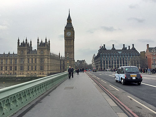
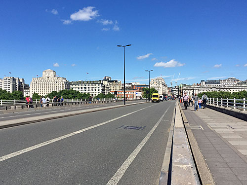
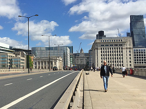
This was Westminster Bridge in March.
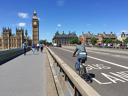
This is Westminster Bridge today, with added Hostile Vehicle Mitigation Barriers.
These were installed last weekend along the full length of the bridge, to protect pedestrians from vehicles driven by anyone with murderous intent.
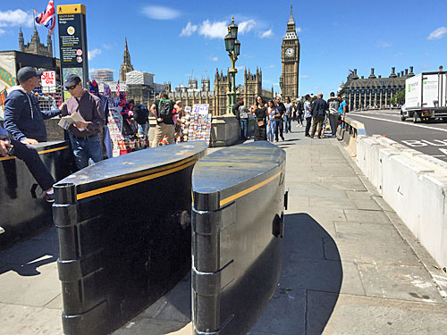
Vehicles are prevented from entering either end of the pavement area by streamlined metal barriers, of the kind that have been used around Parliament for many years.
Pedestrians are no longer able to cross the bridge, except at either end.
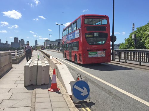
The same thing has happened on Waterloo Bridge.
The new barriers have a temporary feel, but there's no telling how long they might remain, nor whether a more permanent arrangement will be introduced.
Pedestrians used to be able to cross the bridge at any point, via the central reservation. This is no longer possible.
The bridge may be safer for pedestrians but the cycle lane is now about half its previous width, making it more dangerous for cyclists.
A more disruptive installation has taken place on Blackfriars Bridge.
Both entrances to the North-South Cycle Superhighway, and the pavement either side, have been blockaded with heavy metal barriers.
Cyclists are only able to ride through the obstruction in single file, which is causing hold-ups at peak periods.
Here's one cyclist pedalling through the wrong gap to overtake a slower cyclist.
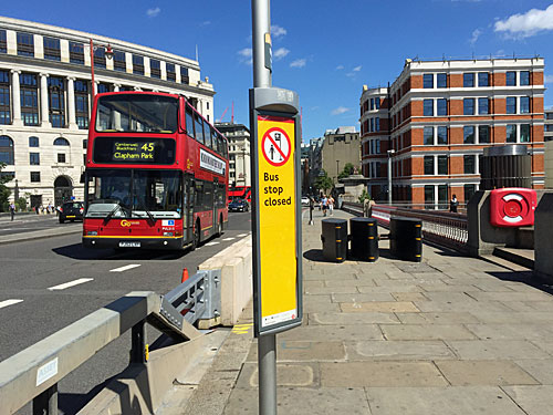
Meanwhile two bus stops on the bridge have had to be closed, because the barriers mean it's no longer possible for passengers to get on board.
The only advice for would-be passengers is a generic notice saying "Please use next available stop", with no indication where that is, or how far.
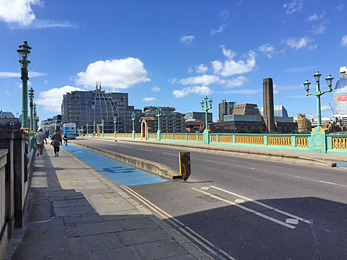
Oddly at Southwark Bridge, the next road crossing over the Thames, no changes have been made.
The only barrier is a low concrete ridge about a foot high, installed a few years ago as part of the segregation of Cycle Superhighway 7.
Concrete blocks have not been added at either end of the bridge, so it remains perfectly possibly to drive a vehicle up onto the pavement/superhighway for its entire length.
Presumably Southwark Bridge isn't deemed famous enough for terrorists to consider it a target.
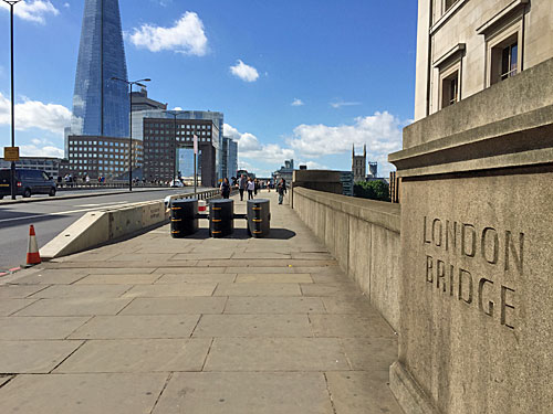
London Bridge, however has been swiftly barriered off.
The full width of the bridge used to be potentially accessible to pedestrians, cycles and rogue vehicles. Now cars are kept to the road and pedestrians are restricted to the pavement.
However, the barriers have been erected in a bus lane, which is now too narrow to be easily used by buses.
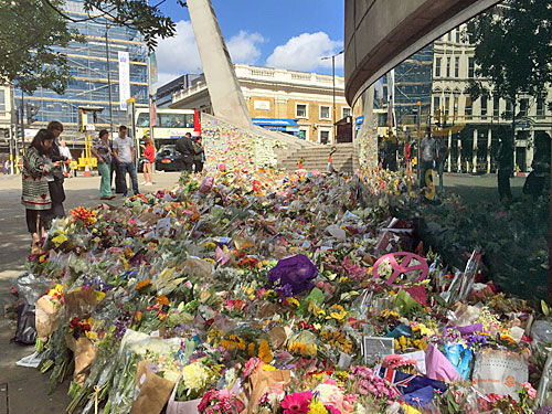
At the southern end of the bridge is a poignant reminder of why these barriers have been deemed necessary.
If two famous bridges can be targeted by terrorists, who'd bet against a third?
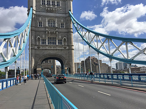
Even Tower Bridge has been given additional protection.
There have been safety barriers across the central span, where the bridge rises, for many years.
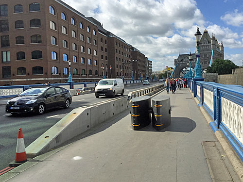
What's new are these barriers on the northern approach, where the bridge runs along the edge of the Tower of London's moat.
They're not exactly scenic, compared to the ironwork, but they do prevent vehicles from mounting the pavement.
They also prevent buses from opening their doors.
Two bus stops have been closed until further notice, and again the advice provided is less than helpful.
Inconsistently, there are no barriers on the southern approach.
There are also no barriers at thousands of other spots across London where a vehicle could drive into pedestrians and cause carnage.
This extra protection has served to move the problem elsewhere, and made our bridges harder to use and less safe to cycle across. Let's hope these hasty obstructive barriers won't become a permanent fixture.
The SNP's majority of 21 in Perth & Perthshire North would have been wiped out if just 11 people who voted for the SNP had voted Conservative instead. Not voting one way brings the majority down to 10, and then voting the other way creates a Conservative majority of 1.
Here are the next seven most marginal Conservative losses.
Had these seven majorities also swung to the Conservatives instead of Labour then the Conservatives would have had 326 seats out of 650, which is technically a majority. And for that to happen, what's needed is for half of those forming the majority to switch from red to blue.
Adding the switcher figures for all eight constituencies gives a total of 399.
399 voters choosing to back Theresa rather than the opposition would have raised Tory support sufficiently to create a majority Conservative government.
Caveat: Sinn Féin never turn up at Westminster, so the winning post is effectively 323. And 323 seats is a target the Conservatives could have reached with just 75 more votes!
However the figures fall, the fact remains that there are fewer than 400 voters on whose choice the outcome of this election hinged. If you changed your mind in Perth, Dudley, Crewe or Canterbury, one of those people could be you... and you changed the future.
21:59 The polls close in one minute's time. Is Theresa May heading for a landslide, or has Jeremy Corbyn inspired a Labour surge which'll hold her in check? It'll be the former, surely... 22:00 Bloody hell, what happened there? The exit poll shows the Conservatives on only 314 seats, which is less than they got in the last election, which is miles off what the opinion polls had been predicting. If that's correct then... oh blimey, let's all pick ourselves off the floor and work out what this means. 22:30 The pound has collapsed two cents already. The markets hate uncertainty. 23:00 Newcastle declares, beating Sunderland to the first result, with a 2% swing to Labour. A swing to Labour, golly. 23:45 The other Sunderland seat suggests a swing to the Conservatives, so maybe they're doing better than expected, which is still worse than expected, maybe, it's all still really unclear. 00:25 If you're reading this in the morning you probably have a good idea what's happened. We're still not really sure. 00:50 With early results trickling through, it looks like the Conservatives might be doing well in the north of England while Labour are doing better than expected in the south, which is opposite to the way things used to be, but might reflect the Leave/Remain divide. Maybe. 01:15 More results, better for Labour than expected, not that much was expected. Theresa can't be enjoying this. 01:40 In results thus far, a 1% swing from Conservatives to Labour, which nobody would have believed four hours ago. Someone just mentioned a minority Labour government for the first time, though still not entirely convincingly. 02:00 London is going heavily red. The North and Midlands might be turning bluer. Scotland's SNP yellow is slipping away. But how will it all add up? 02:15 The BBC forecast nudges up to 322 for the Conservatives - still short of an overall majority, but within practical touching distance. 02:40 Jeremy's leadership looks safe, Theresa's premiership much less so. And what of Brexit? Huge questions, no answers. 02:45 There goes Nick Clegg, because Coalition kills... but straight afterwards Cable comes back. 03:15 In Islington, Jeremy's majority is greatly increased. In Maidenhead, Theresa easily outflanks Elmo and Lord Buckethead. 03:30 University towns have seen huge swings to Labour. Paul Nuttall's UKIP challenge disintegrates. 04:00 With 200 seats still to be called the forecast is C318 L267 SNP32 LD11, which looks to be a Parliamentary mess, but a few more seats either way could realign the final outcome. 04:15 The sky is brightening blue. The country isn't. 04:20 Alex Salmond loses his Gordon seat. The Home Secretary is enduring a tight recount. 04:30 Projected vote share is Con 43% Lab 40%. The final poll of polls said 44% 36%. The last time the two main parties both topped 40% was 1970. 04:50 Michael Portillo is long gone, but Enfield Southgate flips back from Conservative to Labour again. 04:55 Simon Hughes fails to retake Bermondsey and Old Southwark. The Home Secretary narrowly survives in Hastings. 05:00 Will the DUP's ten MPs ally with the Conservatives (318?) to prop up the government? 05:15 Jeremy Corbyn has delivered a much better result than expected (with the support of an invigorated youth vote), although is nowhere near winning (so has failed). 05:20 Theresa May called an election to confirm her mandate, but has thrown away her majority and probably won't be around for long. But who will replace her? (Oh God not Boris) 05:30 On mornings like this, it's so hard to decide when to grab some sleep.
08:30 Right, what happened there? Blimey, what a mess. 08:32 OK, so Thurrock (maj 345) just about stayed blue, Zac Goldsmith squeaked back in Richmond Park (maj 45) and Kensington remains too close to call. Labour's vote share in the capital looks like being around 50%. 08:35 The Conservatives look like they'll fall half a dozen seats short of an overall majority, and "the PM has no intention of resigning". Yeah right. 08:55 Here comes that coalition of chaos they warned about, led by the people who warned against it. 09:00 Likely electoral calculus... Con+DUP=318+10=328 ... not strong, not stable. 09:30 Mathematically the ideal coalition would be a Conservative/Lib Dem coalition, but hard experience will prevent that from happening. 10:30 The DUP appear to have come to an agreement with the Conservatives, based on unspoken (but crucial) NI-related conditions, so Theresa May will be able to go to the Palace to ask the Queen to form a government. 10:40 UKIP leader Paul Nuttall resigns. 12:00 Theresa May's election gamble has backfired, just as David Cameron's referendum gamble backfired. No Tory will be keen to ask voters again soon... but expect to be asked again soon.
6♦ Chingford/Walthamstow The former boroughs of Chingford and Walthamstow were once destined to merge, that is until Leyton was added to create what we now know as Waltham Forest. The chief river hereabouts is the Lea, but I've chosen to walk the length of another which starts in Epping Forest, and (conveniently) flows through the two boroughs in question.[8 photos]
THE UNLOST RIVERS OF LONDON The Ching Chingford → Highams Park → North Circular (6 miles)
[Ching → Lea → Thames]
The Ching, obviously, is a river in Chingford. Less obviously the river got its name from the town rather than the town getting its name from the river. In its upper half the Ching is easy to follow, and rather pretty. In its lower half, alas rather less so.
The Ching drains a central part of Epping Forest, specifically the woodland between Chingford and Loughton. The chief feature at the source is Connaught Water, an artificial lake dug out by hand in 1880 to keep the marsh in check, and shallow enough to be used for paddling in and hiring out rowing boats. These days the main action is around the lake rather than on it, with pleasure seekers enjoying a half hour circuit from the car park past numerous brazen waterfowl. It's peak youngling season at the moment, which necessitates stopping at regular intervals to coo over nuzzled ducklings and cygnets waddling up the path.
The Cuckoo Brook, a minor tributary, joins just below the lake and marks the official dividing line between Essex and London... a function then taken over by the Ching itself. It crosses Ranger's Road, at this point a trickling channel lost in nettles, fairly close to Queen Elizabeth's Hunting Lodge and Chingford's other historical treats. A footpath runs alongside with the river mostly screened from sight, and instead the buttercup expanse of Whitehall Plain to enjoy. Bumblebees traffic from flower to flower and magpies hop down from old oaks - this corner of only-just London is a charmer.
South of Whitehall Road it's again hard to realise the Ching is there, not unless you cut into the trees to discover a stream weaving below thick beech cover. The main path remains open but rutted, with occasional muddy dips which suggest boots are a must-have in the winter months. One ivy-clad tree is currently bedecked with pale stacked fungi, revealed on the neighbouring stump to bear a striking resemblance to freshly-flipped pancakes. Another tree by the golf course bears a single Vote Labour poster, not that it'll swing the clubbers' vote, and Iain Duncan Smith is sure to be returned here today.
The Ching's finest stretch is undoubtedly through Highams Park, initially as a natural stream with textbook meanders and riffles, should any local geography classes be planning a field trip. Beyond a couple of footbridges the water broadens out to form a long artificial lake, dammed at its southern end by landscape designer Humphrey Repton for the benefit of the manor house on the ridge. The lake and its surroundings were bought for the Forest Conservators in 1891, hence the continued existence of alder, pollarded hornbeam and willow around the perimeter path, and yellow iris and flowering lilies on the water. A splendid amenity to have on one's doorstep, and another active waterfowl retreat.
By Hale End the river has retreated to a deep channel on a shallow gravel bed, occasionally littered with bollards, trolleys and a selection of European-brewed lagers. Along Vincent Road it skirts a fresh-mown common before disappearing behind buildings for the first time, including a delightful terrace with a variety of mosaic-samples across sequential gables. I wouldn't have thought to risk the subsequent brambly scramble along the backs of garden fences at Brook Park Crescent had not the West Essex Ramblers walked it previously. "The path is at first overgrown but does improve", they reassured, although I saw plenty of evidence of the former and none of the latter.
At River Walk a stream-side alleyway ducks beneath the Overground, enlivened by the mural of a giant owl on the end house. Further road walking confirms that Highams Park is a jolly pleasant place to live, and then a cycleway between a school and a sports field leads to the most jarring sight of the entire walk. A condensed patch of new housing has been squeezed into a rectangular enclosure, with multi-storey terraces packed close to narrow stacked balconies. All is not quite finished, although delivery companies are already unloading for the earliest residents... and hang on, that looks like a Tote board.
The Ching, it turns out, runs in a culvert alongside what used to be Walthamstow Stadium and is now the housing estate the developers threatened. 292 homes now fill the space where hares ran, dogs bolted and generations of punters enjoyed a flutter, and all that remains is the iconic neon facade up one end, and the Tote building and dog kennels at the other. The latter look rather splendid, having undergone 'sensitive refurbishment', and are now fronted by sufficient raised earth beds to act as 'pocket allotments' for 7% of the residents. But the apartment blocks in the centre could be anywhere, and in no way "truly enhance and celebrate the historic character of the stadium", except in the developer's pipedreams.
The final opportunity to walk alongside the Ching is a paved path connecting two supermarkets. One's the enormous Sainsbury's opposite the stadium and the other's a slightly smaller Morrisons, joined by a municipal cut-through past nettles, sports grounds and buzzing pylons. This emerges into part of the Chingford Hall Estate, a modern creation whose shopping parade is two-thirds takeaways and whose pub is already boarded up. At the far end of Ching Way are a pair of dragon mosaics and a plaque unveiled in 1994 by the Rt Hon Lord Tebbit of Chingford C.H., plus a deliberately tall brick wall to block out the roar of the North Circular immediately behind.
Enjoy the view from heights of the A406 footbridge (Docklands tick, Shard tick, Gherkin tick, Ally Pally tick) because the Ching's last quarter mile is somewhat desolate. It emerges from culvert alongside an overgrown back lane where lorry drivers sleep, it skirts the rim of the Banbury Reservoir past a compound guarded by an angry dog, it nips round the back of a barricaded Victorian pumping station, and it ends alongside a truly grim road despoiled by mountains of trash unloaded from skip hire trucks. A break in the concrete banks of the Lea beneath a chain of pylons marks the point where the Ching finally disgorges its load - an unsightly end, and to think, it started so well.
I grew up in the Green Belt just outside London. We liked to call Croxley Green a village, even though it had a tube station, not least because it was entirely surrounded by fields. To the west was the pastoral Chess Valley where the sticklebacks twitched, to the north rolling arable land as far as the eye could see, and to the south and east a protective strip of woodland and moorland along the Grand Union Canal. The village green ran for almost a mile from a farm and a duckpond to the parish church, and every summer the residents came together to garland a Revelsprincess with a crown of flowers.
In truth rural life was an illusion. Only a handful of Croxley's ten thousand residents worked on the land, the rest of us leading cosy suburban lives along Metroland avenues with a library, two secondary schools and five parades of shops. The parish church was late Victorian, thrown up to serve a few streets when Dickinson's paper mill opened, and the Revels (as Betjeman cruelly observed) was "a tradition dating back to 1952". And yet our lives were subconsciously coloured by the presence of an agricultural envelope - the knowledge that in whichever direction you walked you'd always reach unbuilt-up land before you reached either of the towns nextdoor.
The Green Belt is the subject of a new book by John Grindrod, called Outskirts, in which he explores the evolution and influence of the city fringe. John's previous book Concretopia focused on post-war planning, whereas the follow-up starts a little earlier and concentrates on the setting, not the buildings. Within its 300-odd pages John dissects the British obsession with the countryside, unpicks the secrets of the Green Belt and muses on what it was like to grow up in Croydon on the last road in London.
Specifically John grew up in a gabled semi in New Addington, in Fairchildes Avenue, where one side of the road was housing and the other was the Green Belt. A long wedge of mid 20th century estate covers the upland, whereas the adjacent land remains fields and deep wooded valleys, occasionally scarred with the detritus that urban fringe dwellers throw away. This had once been the landscaped grounds of a great mansion before being pencilled in for housing, but Green Belt legislation was enacted in the 1950s and the vista was saved. John tells how civil servants were sent out in cars around London to mark on maps the precise edge of all existing development, and this became the sacrosanct green belt boundary we know today.
I went to listen to John last night in conversation at Waterstones in Piccadilly, reading extracts and discussing themes with Catherine Croft, Director of the Twentieth Century Society. He touched on how the idea of a Green Belt came about, and the awkward legacy it leaves today. He rued the decline of town planning as a career, as councils now rely (surreptitiously) on private developers to extend their housing stock. He explained how the peripheral nature of his upbringing had affected family life, in a home where cats and comedy were the staple basis of conversation. And he signed my copy of the book on the way out. I read the Croxley chapter on the journey home.
As is John's style, the chapter weaves three narrative threads to tell a complete tale. There's John's visit to Croxley to meet a former resident, born when the satellite town was new and planning rules were lax and laissez faire. There's a summary history of the London County Council's early investigations into the preservation of an outer undeveloped zone, and similar moves around other UK cities. And there's a series of anecdotes from the Grindrod backstory, because this is very much a partial autobiography, observing how the family's everyday life related to the built and unbuilt environment. As with Concretopia, it makes for a fascinating and often humorous read.
I will at this point declare an interest, and say that John interviewed me for the book as well. He mentioned he was trying to base a chapter on Croxley, and I mentioned I grew up there, and we met up in Foyles cafe for a chat. I recalled what it was like to live in a pseudo-village, and some of the quirks of the neighbourhood, and John recorded our conversation to play back later. We're both children of the outskirts, so we had plenty to say. John also interviewed other residents, and it's one of these whose reminiscences form the backbone of the Croxley chapter, not me. But I'm still chuffed because my Dad was a friend of this particular family, and they lived in the same road as us, so the whole thing still feels unexpectedly personal.
I'm looking forward to reading the rest of the book, and finding out more about Letchworth, Chelmsley Wood and John's mum Marj. If you're reading this you're probably target audience too, whether your interest is policy, property, place or a prosaic portrayal of a 70s childhood. A lot of us grew up in the Green Belt, and its legacy continues to affect us all.
A place which, on a certain date at a certain time, you should not be.
A place which will live in infamy, whose name will be spoken of in sadness in the years to follow.
A place which, simply by being there, will end or change your life.
A place where action, or inaction, will be the difference between seeing tomorrow or not.
A place where random people will be going about their normal lives; standing talking, sitting quietly, walking with family, out with friends, sightseeing on vacation, enjoying a meal, going to school, heading to work, heading home, boarding a bus, cycling by, with beer or cigarette or newspaper or phone in hand, whatever...
...and then in a split second, or as events unfold, lives will never quite be normal again.
There will be tales of heroism as well as loss. Character will be tested, instinct will kick in, miraculous stories will be told. The terrible event will bring out the very best in people, as well as forcing us to reflect on the very worst.
We cannot foresee where this place will be.
We think we can, but that's because we base our predictions on the past. We add pavement protection to bridges, we remove litter bins from public places, we rifle through handbags on the way into a museum, we erect body scanners at sporting events, we ask you to take your keys and small change out of your pocket, we turn schools into fortresses, we circle public buildings with bollards, we erect rings of steel, we send armed police to station concourses, we ban liquids on flights, we lock cockpit doors, we make life that little bit more difficult for everyone to dissuade someone from exploiting the weaknesses of the past.
This place will be somewhere else, somewhere we haven't thought to protect, or somewhere we cannot.
Any pavement, any street, any shop, any mall, any bar, any restaurant, any park, any match, any concert, any library, any museum, any riverside, any bridge, any subway, any train, any bus, any journey, any suburb, anywhere.
When your weapon is a car, every road is a potential crime scene. When your weapon is a knife, any public place will do. When your bomb is primed and ready, you can remain outside the venue rather than trying to take it in. When armed police are standing where you were thinking of initiating your atrocity, you can walk a short distance away and do it anyway. Killing people is surprisingly easy, but thankfully almost all of us are programmed never to consider it.
We do all we can to reduce the possibility, but we cannot design risk out of daily life.
The absolute vulnerability of this place will, however, be obvious with hindsight.
We should have installed more cameras, we should have added barriers in the cycle lane, we should have patted people down on the way in, we should have stepped up patrols, we should have reported the suspicious behaviour, we should have spotted the equipment being purchased, we should have read a chain of emails in advance, we should have followed up one piece of intelligence amongst thousands, we should have taken their obvious hatred seriously, we should have intervened with education during formative years, should have, couldn't have, didn't.
This place will claim its victims anyway, as is its destiny, whenever that may be.
The date will hopefully be far into the future, but it could be next year, next month, this afternoon.
Such terrible incidents are thankfully rare. Over the last decade, almost none. This year, too many, but not many.
We remember the handful of atrocities that were unspeakably successful, but it's easy to forget quite how many tens of thousands of times we went about our normal lives and nothing happened.
There is a place in London which, on a certain date at a certain time, you should not be. Some people will be there. It would be ghastly if you were there. You almost certainly won't be.
We cannot live our lives in fear, or terror has won.
7♠ Wembley Two former boroughs came together to make the London borough of Brent, namely Wembley and Willesden, with Wembley to the west of the river Brent and Willesden to the east. Having only visited Willesden a couple of weeks ago, my deck of cards then dealt up the other half, so back I went. And what I wanted to know this time was, what the hell is going on around Wembley Stadium?[10 photos]
Around Wembley Stadium
The new Wembley Stadium opened 10 years ago, a fortress of steel and glass overtopped by a signature arch. Its arrival has triggered a whirlwind of regeneration, as Brent council and a tranche of developers seek to transform the surrounding area, with much swept away and much more yet to come. If you've not visited for a while, it's quite a shock.
What's growing here is an 85 acre neighbourhood called Wembley Park, a name harking back to the landscaped Georgian gardens and Metroland pleasure grounds that once covered the site. You'll hunt in vain for a recreational expanse of grass today, the 'park' the developers have in mind being more of a mixed-use events destination stacked with boxes for sleeping in.
The view from the tube station hasn't actually changed too much since 10 years ago. The offices at this end of Wembley Way were already in place, along with a low-brow low-slung Curry's, but the hotels just beyond are more recent. Eventgoers now pause for coffee and muffins where previously they'd have grabbed burger and chips, and the tiled Live Aid mural in the subway has been plastered over with adverts for concierged apartments.
Looking the other way, back from the podium, the residential revamp appears much more dramatic. Those mundane blocks on the right are student accommodation, because hutches are where the money is, while the liftshafts rising on the left belong to the exclusive Alto Apartments.
On this very spot just five years ago the last remnant of the British Empire Exhibition lingered on, the Palace of Industry, living out its last days as a distribution hub for Yodel. Betjeman adored it, but who needs memories of the 1920s when the mortgaged of the 2020s need somewhere to live?
Wembley Arena is now the sole listed survivor hereabouts, built for the 1934 Empire Games, its pristine white frontage rippling with silent adverts for Coca Cola, Uber and a Steps concert in November. I should say that officially this is the SSE Arena, while the stadium itself is 'Wembley Connected by EE', these alphabetical brand appendages deemed essential to finance buildings which spend 95% of their time echoingly empty.
A little further round is the London Designer Outlet, opened four years ago to purvey past-it fashions to the populace of northwest London at knockdown prices. This triple-decker mall acts as the thriving hub of the new Wembley when there isn't an event on, drawing crowds who pick over trainers, handbags and Le Creuset, drop in for a movie and, most importantly, hang out at one of the high concept chain brand restaurants that fill the upper floor.
In prime position on site is Brent Civic Centre, the council's payback from the developers, a large glass box containing municipal offices and a replacement library, topped off with a ribbed-drum meeting space. Anyone can pop inside for a sitdown on the atrium terrace, a book or (weekdays only) a cheap cup of tea. Meanwhile the dayglo compound of artificial football pitches out front has vanished, the fun is over, because such prime land was always going to be flats.
The Sunday Market's also long gone, and the surrounding car parks are slowly being eaten away. And yet look down from the eastern rim of the stadium podium and almost nothing has altered, the adjacent trading estates still very much a going concern. Warehouses, workshops and commercial units proliferate, from meatpackers to vanfixers, because Brent's small businesses still need somewhere to make a living... for now.
For the most unexpected view of Wembley Stadium, double back to the opposite side of the railway and find the entrance to Sherrins Farm Open Space. This is a genuine and longstanding recreational amenity, a local park for very local people, even if the slope and roughcut grass make the surface less than ideal for anything better than a kickabout.
In the surrounding avenues Wembley's Metroland survives unscathed. Betjeman would recognise the hedges, bay windows and leaded lights, if not the Asian families who now make up over 80% of the inhabitants. Looking at their sturdy spacious homes with gardens, it's easy to conclude that they're Wembley's true winners, not the cash-rich incomers being packed into highrise boxes on the premier side of the tracks.
A lot of London borough boundaries follow rivers, actual or lost, for part of their length. This is an attempt to list them all. It won't be complete or correct.
THE NORTH DOWNS WAY[Day 2] Guildford to Westhumble(13 miles)
There are no designated start/finish points on the North Downs Way, but walking Day2 from the Wey valley to the Mole valley is pretty much a given. It's also, I'm afraid, a bit dull. Not totally, there are some excellent bits, but far too much of the walk is through woodland without much of an overview of where you actually are. That's good news on a blisteringly hot day, like the one I had, because you can hide from the sun for most of the walk. There were a couple of times when I nearly stopped to slap on some sunblock, but then the path sidled back under cover and my cream would have been entirely unnecessary. For thirteen long long miles.
From the Wey footbridge, and cattle lumbering by the waterside, the path wiggles off across the marshes to reach a recreation ground and a residential road called Pilgrims Way. This (and the path that extends beyond) follows an ancient track used by the Canterbury-bound, rutted and rising slowly between birches and pine. During a brief break from woodland a hawk flies above, ponies graze and a man with a low-slung OS map strides past. A geological sign that we're on the Greensand Ridge is underfoot, the path resembling an orange sandpit as it climbs to a stunning contoured hilltop. The sole building up here is St Martha's Church, an 18th century rebuild now used as a wedding venue - hopefully the semi-panoramic views make up for difficulties in getting the guests up and down.
With this ticked off, the North Downs Way nips across Wealden fields to join the North Downs proper. The view from Albury Downs is splendid, the path crossing a stretch of grassy scarp from which successive sweeps of southern hills retreat into the distance in pastel shades. The increasing presence of picnickers and dogwalkers hints at the existence of a car park behind the trees, and there it is, plus a visitors centre and cafe counter to serve them all. It was here at Newlands Corner in 1926 that Agatha Christie famously abandoned her car and disappeared, whereas today you're more likely to find motorbikers, horseriders, cyclists, even firemen dropping in for a break and a burger lunch.
Almost nobody heads across the A247 to follow the drove track into the trees, because there's nowhere to spread out a rug or sprawl, merely four miles of forest-walking ahead. During this time the only people I pass are two young hikers at opposite ends of the muscle spectrum, and a quartet of school-age boys with sleeping bags poking out of their rucksacks, enjoying a little light techno to fill the time. The villages of Shere and Gomshall go entirely unnoticed at the foot of the slope, bar a couple of lone fingerposts, while the occasional sign reveals that the National Trust lay claim to the upland. I don't usually mind walking in woodland, but insufficient variety caused this section to drag somewhat.
At last the path descends slightly and narrows, opening out onto Blatchford Down for a much-missed vista across tumbling chalk grassland. Here too are cattle, hopefully out of sight but potentially massing stubbornly on the upper path as if to dare you to approach. Keep an eye open for a succession of abandoned pill boxes, of the wartime kind, and for other walkers... I went a full hour without seeing a single one. At White Down Lease the NDW crosses its first public road for three miles, a narrow empty lane barely wide enough for a car, and a reminder of how completely the scarp of the North Downs inhibits transport links. All the main routes run parallel down below, including the Dorking-Guildford railway which interrupts the birdsong backdrop twice an hour.
The path clings to the 190m contour over gnarled birch roots and an intermittent carpet of tiny blue and yellow woodland flowers. At one point I came face to face with a deer on the track, which stared briefly and then withdrew into the foliage to stare some more, before engaging full retreat. At the foot of Ranmore Common a brief break in the treeline reveals the glorious view that deciduous cover hasn't previously allowed you to see. The town of Dorking spreads out ahead, the spire of its parish church appealingly dominant, while across the valley on the Greensand Ridge a tower in a forest clearing marks the top of Leith Hill, the Home Counties' highest peak.
Ranmore is the first settlement resembling a village in over ten miles, though technically a collection of buildings to support the local mansion, Denbies, which has been artfully hidden behind a screen of topiary. Its most impressive hanger-on is the church of St Barnabas, a scaled-down 'cathedral' in High Victorian Gothic designed by George Gilbert Scott. The Denbies estate now supports one of England's largest vineyards, and for a brief spell the North Downs Way follows a private track immediately above descending trellises of emergent grapes. But only brief, as the final descent into Westhumble alas eschews the winery and visitor centre for another shielded woodland path.
Day 3, I can assure you, is a much more satisfying hike.
For a blog that's notionally about London, I'm sorry I haven't written about London very much lately. There is a good reason for this, which is that I haven't been in London very much lately. A week ago I went to the West Midlands, over the bank holiday weekend I was in Norfolk, on Wednesday I went to Southend and yesterday I was in Surrey. But today I am in London and intent on staying here, so I thought I'd liveblog my day to wrench the narrative firmly back to the capital.
07:00 I am still asleep. 07:40 Woken by the noise of an email. Kettle on. 07:44 Delete email. Drink mug of tea. 08:11 Noises I can hear outside - a baby crying, birdsong, planes flying over, demolition work. 09:00 Mulling a bath. 09:30 I weigh less this morning than I have for the last twenty years. I blame the long walks. 10:07 This time yesterday I was in Chessington, sat in a bus shelter, listening to two pensioners debating at length where an ambulance and a police car might be going. Today I am at home having another cup of tea. 10:44 Sun's gone in. 11:16 Two of the timetable panels at Bus Stop M went missing a couple of weeks ago, and are still missing. The only timetable that remains is for the N205 nightbus, which is a fat lot of use. 11:49 Considering a third cuppa. 12:08 Nextdoor are bashing the wall rhythmically. 12:22 Nearly left the house in a t-shirt with a melted Magnum stain down the front. 12:29 It's nice out. Two groups of workmen are having their lunch sat outside the McDonalds drive-thru by the Bow Roundabout.
12:33 These five parking spaces on Bromley High Street can only be used two hours a week, during Friday prayers at Bow Central Mosque.
12:41 The staff in my local pharmacy always look really surprised when I say I have to pay for my prescription. In ten years I've never seen anyone else paying for theirs. 13:15 Mmmm, toast. 14:02 Taking the rubbish out. 14:07 Struggling to open the next binbag on the roll. 14:14 Workmen are gingerly demolishing the empty commercial block attached to the listed Georgian building at 223 Bow Road. 14:26 I've arrived at the supermarket during the post-mosque rush. 14:38 We daytime shoppers get a choice selection of reduced foodstuffs to choose from while the rest of you are at work. 15:00 Home lugging four bags of groceries just before it starts raining. 15:32 Enjoying a cup of tea (and a 60%-off Welsh cake) as a mighty thunderstorm breaks. 15:58 Spectacular monsoon now limping to a close. 16:21 Checking the rainfall radar to confirm that the next storm will hit Barking, not Stratford. 16:26 The Friday evening jams are building up on approaches to the Bow Roundabout. 16:36 West Ham's lower stadium seating has been removed and laid out on the tarmac behind Pudding Mill Lane station. 16:55 Pop into bookshop. Check something. Exit bookshop. 17:11 Safely home again before the next round of rumbling and rain. 17:48 London Open House guidebooks are now available for pre-order (the code GUIDE17 gets you 10% off, if you want to save 70p). 18:15 With less than a week until the General Election, my entire haul of delivered leaflets is one from Labour and one from the Lib Dems. Thus far there is no evidence of the Conservatives running any form of campaign in Bethnal Green and Bow, not even on social media. 18:37 Roast Chicken & Pancetta Bake, plus carrots, mushrooms and peas, since you ask. 19:00 Start writing about another trip I made outside London, so you can read that tomorrow.
The least used station in... Norfolk BUCKENHAM (Annual passenger usage: 134)
Thus far I've visited the least used stations in Berkshire, Hertfordshire, Greater London, Essex, Bedfordshire, Surrey, Buckinghamshire and Kent, each of them with fewer passengers than the station before. But Norfolk takes things to another level, with a station that averages less than three passengers a week, and is currently the 13th least used station in the entire country. You might have expected Norfolk's crown to go to Berney Arms, the isolated Broadland halt two miles from the nearest road, but that's seven times as busy as nearby Buckenham. Allow me to try to explain why, starting with the timetable.
from Norwich
to Norwich
Monday - Friday
no trains
no trains
Saturday
1018
1620
Sunday
0949 1149 1549 1711
1018 1039 1239 1639
Buckenham is a weekend-only request stop, with just one opportunity to visit on Saturdays and four on Sundays. It sits on the remote Wherry Line through the Broads east of Norwich, a few miles before it forks one way to Lowestoft and the other to Great Yarmouth. The River Yare meanders close by through open marshes, while a short distance away is the village of Buckenham, a cluster of a dozen buildings on what passes for a hill round here. Alone in the middle of a field stands the flint church of St Nicholas with its octagonal tower, and abreast the narrow lane leading down to the river is a station where almost nobody goes.
Two do-it-yourself level crossing gates block the lane, with a platform leading off to either side. The eastbound runs alongside the old station house, now a three bedroom bungalow with a bouncy trampoline out back, and very few nosey passengers to interrupt residential privacy. Look out for the ¾-milepost partway down, the yellow tactile strip protecting passengers from the rush of daily non-stoppers, and hoops for two bikes should anyone ever choose to use them. But a slow handclap for whoever turned up and replaced the timetable on the noticeboard last week, because it's for the line between Lowestoft and Ipswich, not this line, and hence of no use whatsoever.
The westbound platform is harder to reach, accessed two minutes up a trackside footpath leading off into the marshes. A small green shelter has been provided, plus a separate row of metal seats, between them sufficient to accommodate an entire month of Norwich-bound travellers. If you're here at dusk you can sit and watch the rooksandjackdaws rising from the wires to swoop above the woodland of BuckenhamCarrs, although you should make sure you have alternative means of transport because you've probably missed the last train.
If searching for a reason why rail travellers might visit this isolated spot, one answer is the RSPB reserve alongside at Buckenham Marshes. Follow the lane half a mile down to the river's edge where a wooden hide looks out over acres of grazing land and drainage ditches. For the finest spectacle come in late autumn or winter to see England's largest flock of bean geese together with up to ten thousand wigeons. In May the main action is the herd of cows and calves lumbering beside the dirt track, and the steady procession of yachts and motor cruisers on the Yare enjoying a stately Broadland jaunt.
The RSPB have a larger reserve one mile up the road at Strumpshaw Fen. I say road, but again it's more of a lane, and blocked to traffic by a locked level crossing which is another barrier to raising passenger numbers. One further level crossing then leads back across to the visitor centre, where volunteers take your entrance money, flog badges and update sightings on the whiteboard. The first hide gives some idea of what to expect, looking out over an open lake surrounded by reeds, and perhaps a couple of marsh harriers freewheeling above the scrape.
A lengthy circuit heads down to the river's edge and back, via two further hides. Again the local duck population isn't at its peak at this time of year, but those that are here are noisy, and I did spot a Chinese water deer resting in the nettles. Much more exciting was the yellow flash I saw briefly above the fenland boardwalk, which belonged to the UK's largest native butterfly, the swallowtail. This very rare beast feeds off milk parsley, a delicacy only to be found in the Norfolk Broads, and takes to the wing in late spring and summer. How glorious then to spot a second in the long grass by the railway line, aided and abetted by a crowd of visitors surrounding it with large-lensed cameras.
Come to Strumpshaw on a Sunday between Easter and September and you can visit the Strumpshaw Steam Museum, a mechanical heritage collection in agricultural sheds round the back of a farm. Here you'll find traction engines, beam engines, threshers and 1930s fairground rides, plus a 28-seater North Sea escape pod because hell why not? The Christie Cinema Organ lights up and plays nostalgic tunes if there's an organist at the keys, while outside is a narrow gauge railway circuit pulled by a diesel disguised to look a steam engine. This is normal for Norfolk.
Come to Strumpshaw over the Spring Bank Holiday weekend and you get to enjoy the annual StrumpshawSteam Rally, a three-day mass gathering of vintage vehicles and grease-faced enthusiasts. Traction engines of all sizes putter around the site and showground, their owners beaming broadly, and often with the wife or kids or dog in a trailer on the back. Meanwhile thousands wander between the stalls to track down tools or t-shirts to take home, or top up on ale and chips before returning to watch the parade. It is the very epitome of an English day out, and one more reason why Buckenham station deserves more than its handful of annual visitors.

Vote2017: The morning after
The least used station in... Norfolk