LONDON A-Z An alphabetical journey through the capital's museums Pollocks Toy Museum
Location: 1 Scala Street, W1T 2HL [map] Open: 10am - 5pm (closed Sundays and bank holidays) Admission: £5 Brief summary: vintage miniature toybox Website:www.pollockstoymuseum.com Time to set aside: about an hour
If you've got kids and want to take them round a museum full of toys, go to the Museum of Childhood in Bethnal Green. But if you're child-free and would like to remember your own far distant childhood, try Pollocks. The museum's tucked away in the backstreets of Fitzrovia, in the shadow of the BT Tower. Two characterful houses, one Georgian, the other Victorian, have been interlinked and packed with long-past playthings. Every nook and cranny has some childlike treasure crammed inside. It's a bit like Emily's shop from Bagpuss, except that nothing springs to life while you're not watching.
On stepping through the front door, I thought I did a fantastic job of ignoring the Eurovision personality stood chatting to the bloke on the till. Yes, that was definitely, you know... but I politely avoided enquiring about bloc voting and instead passed to the right through the shopkeeper's magic portal. The staircase was lined with glass cases, all the way up to the second floor and beyond, including a selection of American toys (North, South and Central) and some early 20th century card and boardgames. Most looked charmingly old, but a few were disturbingly familiar. I deduced that some of the games my grandparents had got out whenever the young me came to visit were far older than they looked. They don't make ludo boards like that now, but they did then, right down to the tiny mis-shapen dice. As for the archaic Pik-a-Styk box, many's the time I'd played with the clump of painted pointed wooden rods inside.
First room, boys' toys. A case of things to build with (anyone else remember Bayko?), another of shiny metal spacecraft-y robot things, and a third of miniature locomotives. The Ever Ready Electric Train set, for example, included a Morden-bound tube train for 66 shillings and ninepence (battery not included). In another case was a selection of penny toys bashed out in tin for a few marketplace coppers, while rather more traditional was the care-worn rockinghorse resting above the fireplace. Young scientists would no doubt have preferred playing with a twirly gyrospcope, or else some of the fine collection of magic lanterns and zoetropes - for the more visually inclined.
Upstairs again, to a room filled with Mr Pollock's trademark toytheatres. Benjamin Pollock lived in premises on Hoxton Street in pre-trendy Shoreditch, and fed a thriving market in miniature stagecraft during the long years before the dawn of wireless. His renowned toy shop moved from Hoxton to Scala Street in the 1950s, evolving more into a museum, which is why you'll now find Sooty, Sweep and Sue alongside scenes from tiny Shakespeare. I lingered awhile in this room, because I suspected that there were quite a lot of dolls coming up beyond the next set of stairs. I was right.
Wax dolls, rag dolls and china dolls - each no doubt delightful in their own way, but two roomsful all staringforward through glassy beady eyes were quite sufficient to give me the shivers. Rather more endearing were the Edwardian teddy bears, their owners long since passed away, as well as an unthreatening uncensored shelf of jet blackgolliwogs. The intricacy of dolls house design drew some admiring glances, although more from passing adults than passing children. Modern youngsters seemed keen to drag their parents around the museum as quickly as possible (or maybe they assumed there'd have to be a room containing a Wii and PSP eventually, although there wasn't).
The museum contains a wonderfully diverse collection of old toys, both historically and geographically, all with an emphasis on the traditional rather than the perfect. If you're of a certain age there's plenty here to stir the memory (ooh look, a Tri-ang kitchenette) (oh boy, a Chad Valley Give-a-Show Projector). And there's a rather nice toyshop at the end, which I suspect I'll be returning to before Christmas in search of unusual stocking fillers. As it was I left Pollocks feeling unexpectedly old, and yet also delightfully young. by tube: Goodge Street
It's eight years since I got the keys to my flat, ready to start a brand new job in London. The toilet needed a really good scrub, the previous tenant had a letterboxful of unopened bills, and my TV reception was appalling. I loved it.
It's seven years since I was taken out to discover the joys of total Bank Holiday weekend clubbing. The music was tuneless thumping, the crowd was on a totally different planet and the temptation was ignorable. I left early.
It's six years since I had to fight off the unwanted attentions of one of my office colleagues. She was unnecessarily flirty, and mildly over-motherly, and occasionally inappropriately tactile. I believe she's still married.
It's five years since I regularly overdid my hours at work. Loads of stuff needed doing, and I thought it was essential I hung around late to do the lot. It took me a while to work out that going home was more important.
It's four years since I took a week off work to spend time with some friends who then studiously ignored me. They were too busy socialising with new mates, and I was only a temporary sideshow. I've never wasted a week's leave since.
It's three years since I packed all my work-stuff into boxes ready to change desks. I'd shifted desks several times previously, and I've shifted desks umpteen times since. I'm still not entirely sure why it's so often necessary.
It's two years since I spent the weekend with my parents - sleeping on the floor of the spare room, going out for the day to a Tudor stately home, and dining on roast beef and lemon meringue pie. Some combinations are unbeatable.
It's one year since I cleared the living room so that some painters could come round and re-magnolia it. They bish-boshed the walls, and slop-slapped the ceiling, and I brewed lots of tea. I can still see the spot they missed.
It's less than 24 hours since bosses at work announced a significant number of redundancies. I'm OK, thanks for asking, for the time being at least. But I wouldn't dare guess what might be happening in my life one year from now.
On the hottest day last summer, TfL measured the temperature at both ends of several central London tube platforms. Then they took a map of the underground and coloured the lines inbetween those platforms (red hot, green cooler) rather than colouring the stations themselves. The result looks pretty, but isn't a valid way of recording the data. Look at this snippet (on the original map) between Monument and Tower Hill stations, for example. The platform temperature at Monument (eastbound) is orange (approx 30°C), but somebody's decided that it must have got variably cooler along the tunnel to Tower Hill - and that's totally unverifiable. The black-background map, dumbed down by graphic artists at The Times, is far worse because it smooths out most of the station-by-station nuances (eg around Angel or Tottenham Hale). It also fails to mention that the colour-free sections (eg west of Monument) might be because no data was recorded, not because they were cool. Never trust a map that says "Tott. Ct, Road", that's what I say. Still, some people will believe anything if it looks pretty enough.
So I thought I'd abuse the map's information even further by compiling a headline-grabbing but 100%-unverifiable list of London's sweatiest tube lines.
St Swithun's Day results(40 days on): Hasn't the weather been awfully wet this summer? Well, yes and no, and I have the data to prove it. I've been checking the weather every day since Wednesday July 15th to see if at least one raindrop fell on London, or not. It chucked it down back on St Swithun's Day, so the superstitious amongst you might have expected 40 days of rain, but that's not quite the way it turned out...
My data shows that exactly half of the last 40 days have seen rain, and exactly half have stayed dry. That's more damp days (50%) than the long term average (30%) might predict, but by no means a complete washout. So far August has been noticeably drier than July, which is great news if you've been off work recently. Rain has also tended to avoid Saturdays and Sundays, on the whole, whereas every single Thursday since mid-July has been wet. Don't go blaming a dead archbishop for this, and don't blame global warming either. Our weather is merely very good at being random, and next summer's pattern will almost certainly be completely different. In the meantime it's fingers crossed for the bank holiday weekend (and best pack both suncream and a brolly just in case).
Contrary to popular opinion, London isn't a elliptical city. It isn't circular-ish, it isn't approximately round, and it isn't egg-shaped. London would be roughly ovallish were it not for that long wiggly river snaking across the middle. The Thames splits the capital into two geographically distinct halves, and getting from one side to the other is often a lot harder than it looks. Not in very-central London, where crossing the river is a doddle, and not so much out west, where bridges are relatively regularly-spaced. But head out east, especially beyond Greenwich, and traversing the Thames is nigh impossible.
Oh no, London isn't elliptical, it's C-shaped. And heaven help you if you want to cross from one eastern arm to the other.
Tower Bridge is the easternmost point at which crossing the Thames is easy. Beyond that, much harder. There's the East London Line at Rotherhithe (sorry, closed until next summer, look elsewhere). There's the Rotherhithe Tunnel, which is OK if you have four wheels, a bit ropey on two, and possible (but highly unwise) on foot. Are there any buses through the Rotherhithe Tunnel? No there aren't, not any more, so public transport's not an option. The Jubilee line crosses the Thames a magnificent three times, so its contribution to linking London is excellent, but all that disappears when TfL schedule yet another weekend closure. At Greenwich there's a choice of DLR or foot tunnel, at least for the time being (although the council are planning a year-long closure of the foot tunnel in advance of the Olympics, which is very bad news for cyclists who aren't allowed on the DLR). The twin bore Blackwall Tunnel allows road traffic through, plus the 108 - east London's only Thames-crossing bus. Then there's a crossing bonanza at Woolwich (ferry, foot tunnel and DLR), but after that nothing until Dartford, and that's outside the capital's boundaries. Between Bexley on the south bank and Barking and Dagenham and Havering on the north, none shall pass.
I tried getting across the Thames yesterday, from the Leamouth end of Tower Hamlets to the Dome. Mistake. One lane each way of the Blackwall Tunnel was closed, creating lengthy tailbacks for road traffic. I couldn't get the Jubilee line because it was closed, and any DLR crossing would have required a ridiculously lengthy detour. So I thought I'd avail myself of the rail replacement ferry service. When the tube's buggered, folk at The O2 pay Thames Clippers to run a boat across from East India Pier every 10 minutes - which sounded like a good option. But, in a triumph of bad planning, East India DLR station was also scheduled to be closed, so the gate from the quayside to the pier was locked, and I had to take a badly-signed 15 minute diversion to find my way round to the pier from the Blackwall side. That was two boats missed. And, in an even bigger triumph of bad planning, East India station wasn't actually closed after all, so the locked gate was totally unnecessary (and annoying a heck of a lot of other people too). Whatever the O2's website may claim, North Greenwich is most definitely not "So Easy To Get To". Half an hour it took, to get from one bank of the Thames to the other. I could have walked it in five, if only there hadn't been a heck of a lot of water (and centuries of non-investment) inbetween.
It's a bit rubbish, really. Radial traffic in London works fine, but orbital connections go all pear-shaped when they reach the eastern Thames. Permanent river crossings out east have never been a priority, first because of the engineering skill required, and then because of the expense. More recently the environmental costs of any new crossing have come to the fore - a bridge would be cheaper but more damaging, a tunnel would be less damaging more more expensive. We may be getting a new Crossrail link within the next decade, but (several) otherplans remain on the drawing board mired in controversy. All of which leaves certain neighbouring London boroughs anything but neighbours. Because London is actually C-shaped, with a watery divide preventing millions of inhabitants from coming together.
Walking the Lea Valley 8: LOCKS-LEA Broxbourne → Waltham Abbey(5 miles)
If you fancy messing about in a boat on the Lea, head to Broxbourne[photo]. You can hire anything from a pedalo (for an hour) to a narrowboat (for the day), or (if you're feeling refined) go for a river cruise on the "Lady of Lea Valley". I resisted, even the special offer of a cream tea afloat, because none of these options would have deposited me any further down the valley. But the Broxbourne bend is a fine spot for a boating centre because there's a variety of interesting scenery nearby (wooded, meadowy, residential), plus a big riverside pub to recuperate in. And, more importantly, there are no nasty annoying locks close by to get in the way of horizontal watercrafting.
I followed the flotilla downstream, past some vole-filled freshwater marsh and a row of rich Essex houses with boats at the bottom of the garden. At King's Weir the Lea tumbled away to one side, and the towpath continued alongside the Lea Navigation. The artificialness of the waterway soon became clear - broad, arrow-straight and relentlessly featureless. A screen of trees hid the commuter 'burbs of Wormley and Turnford from view, with occasional views of bird-rich filled-in gravel pits inbetween. It was a relief when Aqueduct Lock finally appeared, if only because there'd be something different to stare at. I must say I wasn't expecting that something to be a bare-chested 30 stone man in a Viking helmet [photo]. He had more drooping wobbly bits than my brain could comfortably cope with, none of which were helping his boat party to negotiate to the lock. I moved swiftly on.
This was a lonely stretch, segregated from reality with only the occasional whizzed-by cyclist for company. A two-mile chain of wooden electricity pylons followed the towpath, their elevated cables prohibiting anglers from dangling any lines beneath [photo]. Another change in elevation broke the monotony, this time at Cheshunt Lock, and I took the opportunity to go and stare briefly at another water-filled gravel pit. Then on, past some very keen young canoeists, and a welcome bend at the turn-off to Cheshuntstation. Oh joy, more straight stuff, all the way down to Waltham Common Lock. There were five parallel streams here, and I was stuck on the non-meandering one.
Waterway 1 - Small River Lea: Precious little originality in the naming of rivers round here, eh? Waterway 2 - Lea Navigation: That's the straight one (here with a lot of geese, ducks and swans) Waterway 3 - Millhead Stream: This one feeds the picturesquecanalsystem of the Royal Gunpowder Mills (a fascinating and historic explosive attraction - do go visit) Waterway 4 - Old River Lea: The proper river (and wholly unwalkable) Waterway 5 - Cornmill Stream: On the west bank is the Cornmill Meadows Dragonfly Sanctuary (which is very pretty, but where I didn't see a single dragonfly). And on the east bank is the former GLC Arboretum (which contains my favourite mile-long meridian-followingfootpath between two granitestatues)
A big surprise after the bend at Cheshunt Marsh was the appearance of a sprawling contoured building site. Hillocks of earth had been piled up across a former overspill car park, with red-and-white striped cylinders dotted here and there like discarded slices of seaside rock [photo]. An information board by the footbridge revealed that this was the site of the London 2012White WaterCanoe Centre. There'll be four days of canoe and kayak action down the artificial course, and those cylinders are for the pumps to keep the white water flowing. Unlike the Olympic Park downstream, these facilities are scheduled to open for public use in 2011, with a separate intermediate course as well as the scary world-class rapids. It's early days yet - more of a mudpile than a lake and torrent - but an impressive watersports attraction awaits.
Waltham Abbey: I have a soft spot for the town of WalthamAbbey, because it's jam-packed with little but lovely things. It's only a short walk from Waltham Town Lock into town (you are now entering Essex), past the entrance to the aforementioned Gunpowder Mills to the doors of the medieval Abbey itself. Church services prevented me from getting inside, but the grounds were lovely, including the reputed grave of King Harold and a Meridian gateway at the entrance to the walled garden. The meridian was also marked on the pavement in Sun Street, not far from the small and almost-interesting Epping Forest Museum. Summer Sunday opening at the museum didn't seem to be drawing in the crowds, and the untouched pots of pens and scissors on the "children's activities" table in the garden told their own forlorn story. If you head for the town yourself, pick a sunny day, and remember there's just as much around the edge of town as in the centre. [tourist leaflet pdf]
And yes, that rumbling viaduct in the distance, that's the M25. London beckons.
Walking the Lea Valley 7: RYE-LEA Ware → Broxbourne(6 miles)
On the way out of Ware, the Lea evolves further. The Lee Valley Regional Park starts at the town bridge, stretching 22 recreational miles down to the Thames, so all the waterside signage is suddenly a lot better. There's a bend a little further along where the river finally turns to head south-ish rather than east, starting the long slog down towards Bow and the Dome. And it's here that the waterway splits - the official River Lea meandering one way, and the far-straighter LeeNavigation another. Walking alongside the latter is a whole new broad-gauge linear experience, and a world away from the narrow rippling channel experienced further up.
The valley's rather wider, and lake-ier, from here on [photo]. Along the next stretch are glimpses of various filled-in gravel pits - now the AmwellNatureReserve, whose hides are a great place (if you've brought binoculars) to watch for waterfowl and otters. Hidden behind the trees on the towpath side is the picturesque village of Great Amwell, through which the artificial New River runs - probably worth a brief detour across an unmanned level crossing. There's a greater flirtation with civilisation at St Margaret's/Stanstead Abbotts - two very-neighbouring villages separated only by the Lea. The Greenwich Meridian crosses the river above Stanstead Lock, known for its rare swingbridge (which allows those living in the lockkeeper's cottage to get their car out) [photo].
Rye House: The Island of Rye, surrounded by floodable marsh, has been a select spot for settlement since Saxon times. In 1443 a local nobleman built a fine brick manorhouse by the river here, most of which has long since crumbled, but the entire Rye House gatehouse still stands. It's no ruin, but a nigh-perfectly preserved example of high quality 15th century brickwork [photo]. Finest of all, especially to anyone with a camera, is the tall twisting 'Barley Sugar' chimney on the roof [photo]. And yes, it was possible to climb up there to take a closer look. First of all I had to cross the moat to meet with the gatehouse custodian, guarding her till (and the shop) from marauding invaders. I don't know if it's always the same lady, but the East Ender I met added to the experience by being chatty, forthright and fun. She took my £1.80 and then flicked a switch so I could listen to three wax dummies plotting to kill the King. Oh, yes, back in 1683 Rye House almost changed British history. King Charles II and his brother (King-to-be James II) were due to ride back from Newmarket through the estate, where conspirators planned a monarch-eliminating ambush. All might have worked perfectly if only the royal pair hadn't accidentally saved their own lives by returning home a week early. The Rye House plot could have been fictitious, but its ringleaders were swiftly dispatched nevertheless. After a dash of 'history' on the vaulted ground floor, I ascended to 'architecture' level where it was possible to admire the rendering close-up and learn a bit more about brickery. And then the roof. I love a good roof, especially when I've got it to myself and there's a decent view. Here I could gaze across nearbyHoddesdon, and another nearby bird reserve, plus a large caravan park where the Showmen's Guild store fairground rides over the Winter. That droning buzz to the south was the sound of speedway at the Rye House Stadium, home to the Rye House Rockets (I'm only related to one of them, apparently). All this (plus a station on the doorstep, a decent riverside pub, and rumours of nearby dogging) makes Rye House a compact yet fascinating spot. Add it to the list of places you now know you haven't been.
The Lea continues southward, past the Speedway circuit [photo] and a pylon-infested power station, to be joined by the largest tributary of all - the Stort. That's the river which flows down from Bishops Stortford, obviously, and its also been canalised to enable navigation by narrowboat. There were a lot of boats on the Lea as I walked down, almost as many as there were bikes on the towpath. At Feildes Weir Lock a 50th birthday party (afloat) was in full swing, with the party girl identifiable by a cheap plastic sash and a rather more expensive glass of bubbly.
The next weir was possibly the most picturesque on the whole river [photo]. Dobbs Weir has three long V-shaped notches, which greatly increase the length over which the water can tumble [photo]. They used to be much loved by daredevil canoeists, but British Waterways have now locked them away in lieu of expensive repairs. The area's long been loved by anglers (Isaak Walton included), not just the flat river above but also the weirpond below. Britain's largest chub was landed here (it's been beaten since), and there were plenty of would-be record breakers lining the banks when I wandered by. A favourite haunt of families who never walk more than 200 yards from the car park, I thought, aided and abetted by the presence of a fine pub plus waterside terrace. But that's Essex for you. For the next five miles or so, one's bank's Hertfordshire and one bank's Essex, and it's here at Dobb's Weir that a bridge carries the towpath from the former to the latter.
A leafy curved stretch followed, with the three extensive lakes of Nazeing Meads screened off behind the trees. I'd not have noticed them, nor their watersports, nor the cucumber-packed glasshouses beyond, if I hadn't stepped off the towpath for an inquisitive scout-round. My detour allowed a merry stag party barge the opportunity to overtake, until I caught up with them again at Carthagena Lock[photo]. The lockkeepers here keep a particularly fine cottage, with hanging baskets across the lower gates and a "ring the bell for service" kiosk hidden round the back. Negotiating the descent slowed the floating revellers just long enough to give me a decent head start into Broxbourne, where their journey terminated. Messing around in boats may be a lot of fun, but it sure isn't fast.
» See a canal-boater's view of today's walk (in reverse) here and here.
LONDON A-Z An alphabetical journey through the capital's museums Old Operating Theatre
Location: 9a St Thomas's St, SE1 9RY [map] Open: 10:30am - 5pm Admission: £5.60 Brief summary: Victorian amputation garret Website:www.thegarret.org.uk Time to set aside: up to an hour
St Thomas's Hospital hasn't always been on the banks of the Thames opposite the Houses of Parliament. It arrived there 150 years ago from the area just south of London Bridge, selling up to make way for a new mainline rail terminus. The hospital's existing facilities were either transferred or demolished, except for one section that was entirely overlooked. High in the roofspace above a neighbouring church, two rooms were locked and abandoned and forgotten. One was an apothecary's garret, and the other was the female wing's operating theatre. A century later they were both rediscovered, and later lovingly restored, and now 21st century Londoners can take a look back into squeamish medical history.
You're looking for a church tower near the top of Borough High Street, SE1. Entrance is via the front porch up a surprisingly twirly spiral staircase. You'll emerge in the museum'sshop above the porch (small, but intriguingly stocked), then progress into the exhibition space proper. Don't be expecting something huge - this is a church roof after all - but there's plenty of old medical stuff stuffed inside.
Room one is dark and atticky, and used to be where the apothecary stirred up salves and lotions. This is the Herb Garret, more than 300 years old, and it's laid out with exhibition cases intermingled with bowls of crushedplantlife. You can tell you're somewhere clinical by the green glass bottles, and the leech is a dead giveaway that this is old school medicine. Where else in London is there a "history of the syringe", or indeed the explanation that suppositories used to be made from cocoa butter to help them melt away more easily? A variety of stuffed animals (and animal bits) are on show to educate visitors about some of the more unusual cures, although herbal solutions were far more common. Our ancestors were far more plantly-wise than the current pill-popping generation, and would think nothing of taking elderflower or willowbark in the absence of tamiflu or aspirin.
An adjoining corridor contains a selection of 19th century surgicalinstruments. This being adjacent to a ladies' ward there's a varied collection of forceps (ulp), and also some intimate tools that'll make your eyes water. Lithotomy (the removal of bladder stones) was one of the more common operations performed here, without incision, so there was only one way those pebbly interlopers were being squeezed out. Don't even think about it, move on.
The remaining room is the old operating theatre itself. More an amphitheatre really, with horseshoe terraces surrounding the central space beneath the skylight. A lot of medical students used to attend to observe the operations, this being a teaching hospital, and the (mostly destitute) patients had no cause to complain because they were getting their treatment for free. Don't expect gleaming surfaces, the room had a wooden floor because nobody at the time knew any better. Professional surgeons might have worn a special jacket to keep the blood off, but hygiene was still several years from attaining importance. If the patient died they died, and at least someone had had a go at trying to save them.
Attend at two o'clock on a Saturday afternoon and there's an added treat - a surgical demonstration on the Old Operating Theatre's old operating table. It's an amputation, of course, this being another unpleasantly common mid 19th-century operation. Any compound fracture back then inevitably led to infection, gangrene and death, so chopping off the afflicted limb gave the accident-prone patient the best chance of success. Stick your hand up when asked and you too could volunteer to lie back and lose a bit of yourself. The best doctors at the time could whip your leg off in less than 30 seconds (see this saw, it is very sharp isn't it, imagine that cutting through you six times, that's all it took). There'd be students holding you down in lieu of anaesthetic, and a gag in your mouth to ensure you didn't disturb any church services down below. No such agonies today (and smile, today's volunteers also get a commemorative badge for their services).
You'll leave the museum with some of idea of why life expectancy has increased over the years, and with renewed respect for generations of medical and nursing staff. Our much-loved NHS may have its roots in philanthropic hospitals like St Thomas's, but that doesn't mean you'd ever want to have been operated on here. So try not to stumble on the spiral staircase back down to the street, because there's a lady upstairs with an amputation kit and she knows how to use it. by tube: London Bridge
I received a flurry of emails from readers over the weekend all saying much the same thing - they're fencing off the bridge on the Greenway, your photo series is buggered. So I went along to check, and they were right.
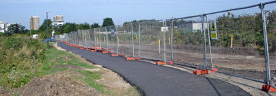
The bridgetop itself is about 20 metres long and 10 metres wide, topped with tarmac, and a convenient way of covering over the enormous sewerpipe beneath. The bridge hasn't been completely sealed off - it's still perfectly possible to get from one side to the other. But the half nearest the stadium has been entirely fenced off, temporarily at least, so that the surface can be completely upgraded and made lovely before the Olympics begins. And this means my stadium viewpoint is in quarantine, and the arena stadium view is through a metal mesh, and my series of identically-sourced photographs is indeed stalled.
There's been very similar upgrade work underway on the Greenway south of Stratford High Street for the last couple of months. First one side of the carriageway gets ripped up and the vegetation trimmed back (with any key plantlife screened off so that contractors don't destroy it by mistake). Next a strip of extremely ugly tarmac is applied, which will allow pedestrian and cycle traffic to continue while the major upgrade is underway. Then the opposite half of the sewertop gets a rather lengthier makeover, laid out with arty cobbles and recycled brickwork for long-term legacy requirements. I went along to the public consultation which set out the Greenway plans, so I'm fairly confident the 2012 lot will do a good job, but for the time being it's a right ugly mess.
Much the same change now appears to be happening on the half-mile stretch alongside the Olympic stadium, but with a handful of key differences. Change is happening quicker, because this is a crucial section used by workers making their way to "Team Stadium". A towering green portakabin has been erected up at the railway end, presumably as somewhere to take official visitors when showing them the view. Three mysterious bus shelters have been added - one near the bridge, one near the Lea and one outside the workplace entrance inbetween. Those bus shelters have got me worried, because they suggest that somebody's planning to run a bus inbetween them, on a route that was once a quiet backwater cyclepath. We'll see.
And over by the edge of the Greenway bridge, alongside the official diamond geezer viewpoint, something new is being installed. I'm not quite sure what it is yet, because only the lowest level is semi-complete. So far there's a long wooden platform, along the entire length of the bridge, presumably because it's a more stable place to stand than the original narrow muddy ledge. But it's not yet clear if the structure's heading higher to become something more private, more security-conscious - to be some sort of 'official' viewing platform rather than just a random place to stand. If it's the former, at least TV crews will soon have somewhere better to film. If it's the latter, I'll be taking no more photos to add to my monthly collection.
Ah well, maybe two-years-worth is a good place to stop. Now that the Olympic Stadium's so far advanced, almost all of the major change has happened already. There won't be much more evolution to catalogue over the next three years, so why waste my time (and yours) with a series of nigh identical photographs? I'll see how long this Greenway evolution takes, and whether the end result is viewpoint or barrier, before making my decision.
Most of us take being British for granted, having had no say whatsoever in the country of our birth. But, for some people, choosing to become British is a very big deal, and not to be undertaken lightly. There are a lot of hoops to jump through. You have to have lived in the UK for at least five years (various technicalities apply). You have to be able to speak English (other home nation languages acceptable). You have to pass a ridiculously difficult "Life in the UK" test that 99% of British nationals would fail (go on, try it). You have to be of good character (no nasty criminals please, because the Daily Mail wouldn't approve). And you have to want to reside in a country full of fish and chips, queues, drizzle, wonky teeth and various other national stereotypes. At £720 per application, plus costs, only a solvent Anglophile would ever apply.
Yesterday I attended my first ever British Citizenship ceremony. It wasn't my own, but that of a fellow blogger to whom I've been electronically attached for years but had never previously met. Did I want to come along to the ceremony as one of the two permitted guests? Hell yes, thank you, much obliged, how very polite of you, how very British. And so I turned up at a London Town Hall yesterday morning, not quite so smartly dressed as my new acquaintance, to see how the entire event worked. And to applaud at all relevant moments, obviously.
There's a lot of paperwork involved in getting through the event. You have to bring the invite letter and various other forms of ID (not a UK passport, because you haven't got one of those yet). These get cursorily checked on the way in, and then scrutinised more carefully about three quarters of an hour later by scrupulous municipal staff. And inbetween you just sit in the waiting room and wait. Oh yes, there's a lot of hanging around before anything important actually happens. The invite said that refreshments would be provided, and I had visions of a traditional British buffet of sausage rolls, curled up sandwiches and Victoria sponge. No such luck. Some coffee, some tea bags, a few cartons of generic fruit juice and a pile of biscuits - still traditionally British, but not in a very exciting way.
At this particular ceremony there were just over 20 foreigners becoming non-foreigners. A very mixed bag, from people you would have known were new to the country to people you'd never have guessed weren't actually born here. An elderly Afro-Caribbean couple wore their Sunday best, including almost matching hats, while others wore headscarves or flowing canary dresses indicative of the country they were leaving behind. As names were called out so that participants could file into the Council Chamber, it appeared that Monday was "surnames A-D" day. As guests we followed along shortly afterwards to take our seats on the party benches. It was slightly surreal to hear the Beatles 'She Loves You' playing over the loudspeakers as we entered, but what better group to use as background music?
The Citizenship Coordinator leading the ceremony had split his charges into two groups - believers on the right and atheists on the left. Those in the first group would get to swear their oath of allegiance to God and the Queen, while those in the second merely had to solemnly affirm the same. Her Majesty was in attendance via a regal portrait in a gold frame, elevated on an easel above head height where she would look good in the souvenir photos. There was some preliminary spiel about community-mindedness and the qualities of Britishness, as if these were somehow properly defined, and then a council dignitary gave a speech about much the same things. One of the best things about this moment, she argued, is that from now on you'll be able to vote in council and general elections. With 2010 approaching, good timing.
A bit of "repeat after me" completed the formal induction (congratulations, you're now officially British), and then everybody stood for the National Anthem. "It's pitched a bit high" said Councillor Smith, as official absolution for not joining in, although most people at least mouthed the words. Just the one verse, no need to overdo things. And finally everyone was called up one by one to sign yet another piece of paper - the official certificate - and to get their photograph taken holding it alongside a beaming Citizen Smith. It was a very informal ceremony, with guests needing no encouragement to rush around snapping photographs throughout, and even a breast-feeding baby in the front row to celebrate true British tolerance.
We queued up at the end for the £10 professional photograph, dispensed almost instantly from a red machine at the back of the council chamber. And then back out into the street - for two of us no change, and for one of us as a very proud fresh citizen. We hunted down a traditional British pub in the High Street, and drank a unspoken toast to inclusion, diversity and pride. Welcome to Briton, mate. I don't know what you did yesterday lunchtime, but I bet it wasn't anywhere near as significant.
Walking the Lea Valley 6: PROPER-LEA Hertford → Ware(2 miles)
Despite being Hertfordshire born and bred, I'm relatively unacquainted with its county town. So when I strode in along the Lea, I was surprised to get a feeling that the place seemed strangely familiar. And then the Shire Hallclock struck two, and that's when the penny suddenly dropped. Trumpton... Hertford's suspiciously like Trumpton. The town centre is a relatively un-wrecked grid of backstreets lined by quaint-ishbuildings - most of them shops, but also including the oldest Quaker meeting house in the world. There are higgledy-houses and meandering alleys, and there are oddly-shaped squares and regimented terraces. There are statues, of the sort beneath which a flower seller might sit, and there are proper greengrocers that sell non-shrink-wrapped fruit and vegetables. It really wouldn't have surprised me to see six lads from the local fire brigade come gliding round a corner at any minute. OK, so the clock didn't perform a merry dance on the hour, and I'm sure Trumpton never had a giant Waitrose tucked away in an ugly brick mall round the back of the bus station. But as generic Betjeman-friendly county towns go, Hertford's survived better than most.
It's in Hertford that the Lea changes, irreversibly, from a tame stream to a deep river. Earlier I'd always thought I might be able to wade across it, but from here on it's proper drownable. The town centre is also the upper limit of the navigable Lea. Set off in a narrowboat from the quayside behind Hertford Museum and you could, if you wanted, chug all the way down to the Thames [photo]. There's a particularly pretty urban section alongside Folly Island, where a row of flower-bedecked cottages face directly onto the river [photo]. Unfortunately the best view is not from the Old Barge pub nextdoor, it's from the tacky terrace of a modern Starbucks on the opposite bank (beside the aforementioned Waitrose).
I headed downstream across the top of a lengthyweir - a popular place for preening ducks, but also home to a number of speculative riverside developments [photo]. Out here in Hertford, there's a premium for a Lea-view address. Then out of town towards the Navigation's uppermost lock[photo], the first of about 20 between here and Bow Creek. From the lower gates there was a fine view out across King's Mead - the 250 acre water meadow that separates Hertford from Ware. The land's never been ploughed, and is maintained as commonland for grazing and as a nature reserve. It's probably quite bleak in the middle of winter, but in midsummer it made for a delightful panoramicstroll.
New River: When 17th century Londoners needed fresh drinking water, and the Thames obviously wouldn't do, an ingenious entrepreneur called Sir Hugh Myddelton turned instead to the Lea. He funded the construction of a 20 mile artificial channel from just-below-Hertford all the way down to Islington, following the contours of the land to avoid any necessity for pumping. The head of the New River is on King's Mead, inside a remote-looking house-type building, with a sluice inside to divert water away from the natural stream [photo]. From here it runs across the meadows towards the edge of the valley (and some additional springs), before running pretty much parallel to the Lea at least as far as the M25. One day, honest, I'll run a detailed feature on the NewRiver and its lost meanders through North London. For now, however, I continued along the proper Lea (and under the A10 KingsmeadViaduct) into the town of Ware.
Ware is an old coaching town, ideally located one day's ride from London on the Great Cambridge Road. It's famous for a couple of things. One is for being an 'hilarious' homonym ("Where are you from?" "Yes, Ware"), and the other is for once having an enormous bed. The Great Bed of Ware was a ten-foot-wide four-poster, carved out of oak around 1590, and capable of accommodating more than a dozen heavy sleepers simultaneously. It started out as an overnight attraction in a local tavern, but has since ended up in the Victoria and Albert Museum. The town's museum in the High Street therefore has to make do with showing a scrap of ripped coverlet, which quite frankly isn't as exciting. Nevertheless I rather enjoyed Ware Museum. It's a good example of just how much can be done with an extremely limited space, including a selection of Hertfordshire brickwork, a WW2 bunker and (at the moment) a geological exhibition on 'Chalk'. The nice lady volunteers who run the place are also charming (unless you're a bunch of irreverent 12 year olds, in which case they'll tut a lot after you've left).
The Lea hugs the town from the south, arriving beside the HQ of GlaxoSmithKline beside a strangely modern weir [photo]. Shortly afterwards the river crosses the route of Roman Ermine Street (but invisibly, so you'd never know), then continues round the back of a Franciscan Priory. Next are the picturesque Waregazebos - a series of white-painted summerhouses perched beside and above the riverbank [photo]. Some are more than 300 years old, while others are more recent additions installed by house owners who fancied a very different style of conservatory at the bottom of the garden. My camera loved them.
» If you're looking for an interesting day out from London, I can recommend a trip to Hertford and Ware (via the Lea inbetween). A bit of heritage, some independent shops and a nice walk - enough to keep you busy. For Hertford you'll need thesewebsites, for Ware thesewebsites and, for the bit inbetween, thesemaps. Visit Ware on a summer Saturday and you could even visit Scott'sGrotto - six underground chambers in a suburban street. But bring a torch.
Walking the Lea Valley 5: HERT-I-LEA Hatfield → Hertford(6 miles)
Mill Green Mill: There's been a mill on the Lea between Welwyn and Hatfield since medieval times. Around it grew a small village called Mill Green, and the the mill's now known (rather circuitously) as Mill Green Mill[photo]. Usual story - fell into disrepair in the early 1900s, restored by a team of volunteers in the 1980s, now run as a museum by the local council. And all rather lovely, apart from one tiny technicality which was that every single person who works there completely ignored me when I visited. The volunteer sitting out the front in a chair by the 'Open' sign, he ignored me. Neither was there anybody at the entrance desk - not that the mill costs anything to visit, but I could easily have walked off with all sorts of local goodies from the shop. Downstairs were a few tiny well-stuffed galleries, including the Miller's Kitchen, some stuff about local railways and a temporary exhibition on Murphywireless and television sets. Upstairs another volunteer was milling grain - properly with stones and spinning wheels and things [photo] - whilst explaining carefully to a father and young son how it all worked. As visitor number three, I didn't even get a nod. I slunk off to check out the millrace (dark and damp) before exiting to the delightful garden where cream teas were being served. I'm assuming that the scones were made from ultra-locally-sourced flour, but I felt 20 years too young to stop and find out, and nobody at the café entrance paused to entice me in. I suspect you might get rather more attention if you turned up.
Hatfield House: The young Princess Elizabeth (Tudor version) spent much of her childhood at the Royal Palace of Hatfield. The present Jacobean house dates from 498 years ago, and was built by her courtly favourite Lord Cecil. Today Hatfield House is a very popular tourist attraction (rather more so than Mill Green Mill), forever putting on big special events during the summer season to attract paying guests inside. I decided to give the place a miss, partly because of the £10.50 entrance charge, but also because of the three mile detour required to reach the other side of the wall from Mill Green. I missed out on seeing the 16 acreBroadwater, formed by a dam in the river Lea and landscaped with a spectacular oak backdrop. Instead I trudged along the A414 dual carriageway, following the estate boundary, as far as the Cecil family's sawmill [photo]. It still churns out profitable stacks of timber - including at some point (I suspect) the chopped-down remains of the oak tree beneath which Princess Elizabeth discovered she was Queen.
At the sawmill I took a risky decision and chose to abandon the official route of the Lea Valley Walk. This has been revised recently due to the closure of a permissive path (somewhere), which requires a detour to the suburbs of Welwyn Garden City followed by a featureless three mile walk along a disused railway. Not a scrap of river in sight, no thanks. Instead I took a delightful bridleway along the banks of the Lea, past secluded angling platforms and a plankless bridge [photo], with not a single other walker in sight. The surrounding cornfields were the first I'd seen harvested, and a reminder that summer's glories won't last forever. A faded sign on a farmyard post revealed that I was on the original LVW, which could only mean trouble ahead.
So then the grim bit. There was no footpath for a mile and a half, nor any sensible off-road detour, so I was forced to walk along a busy B-road avoiding all the traffic for 30 minutes. I strode carefully (swish) round a series of shielded high-hedged bends (swish), and was surprised by how many of the oncoming (swish) vehicles (swish) had personalised numberplates (swish) (swish). After Holwell Bridge the Lea was completely out of sight, either lost within the estate of an exclusive polo club or merely hidden inside a private wood. I was glad to finally escape from the road at Water Hall Farm... until I discovered that I was entering a rubbish tip and had to step carefully to avoid being mown down by huge yellow dumper trucks.
Eventually the rubbly hillocks gave way to grassy fields - the latter reconditioned from the former by the tip owners. I passed one of the Environmental Agency's official gauging stations - a weirside hut where the Lea's flow is constantly checked to alert the authorities of flood or drought. Then on up the valleyside ridge, beside fluffy teaselly hedgerows, for a fine view of distant Hertford nestling amongst the surrounding hills [photo]. Ah, I thought, this route sure beats trudging along a dull old disused railway. And then I reached the dull old disused railway (now the Cole Green Way) and reluctantly trudged along to its shady conclusion.
A railway viaduct (and a lone horse) [photo] heralded the outskirts of Hertford, followed swiftly by the stadium of the town's football team. I say stadium, whereas I really mean a couple of rickety grandstands and a few portakabin huts. Hertford FC aren't having the best start to their league season (played 2, lost 2), and you'll get some idea of their professional standing if I tell you that they've already been knocked out of the 2010 FA Cup. The Lea flows up the eastern side of the ground, where it then joins with its first major tributary - the Mimram. Bolstered by additional supplies, the river flows into the centre of town noticeably wider than before.
Hertford Castle: As many as four different rivers combine at Hertford, so it's been an important settlement for more than a millennium. A castle appeared around 1066, of the motte and bailey type, and its grassy mound is still visible beside the Lea today [photo]. A succession of royal owners took charge, and made regular visits, until Henry VIII finally upgraded the castle to a proper palace. Queen Elizabeth brought Parliament here when London was beset by plague, although King James I was less enamoured by Hertford (poor hunting nearby) and the palace left royal possession. The castellated 16th century building that survives to be called 'Hertford Castle' is really only the gatehouse. Today the building is used as council offices, and opened to the public once a month. The surrounding area is a lovely quiet spot [photo] - a patch of municipal parkland bang in the centre of town surrounded by an (unseen) busy ring road. If you worked nearby, this is surely where you'd bring your packed lunch for a Leaside nibble.
• Griff Rhys Jones is heading down the Lea for his BBC1 Rivers series at 9pm tonight. He'll be spending almost all of the programme visiting the lower half of the river - the bit I haven't reached yet.
Walking the Lea Valley 4: STATE-LEA Wheathampstead → Welwyn(4 miles)
It didn't take long to reach the outskirts of Wheathampstead, and then the relentless countryside began again. A fingerpost on the edge of town offered walkers a choice between "Lea Valley Walk, Waterend Ford" and "Meads Dell, Old Sewage Works". The direction of travel was clear. The footpath soon shifted away from the riverbank, now barriered off for the exclusive use of anglers, then nipped beneath a bypass into a silent field. Here was another fence, this time to protect water voles from human and canine attention - although most of the fuss appeared to be coming from a flock of swallows swooping down from overhead wires into the stream. Only a few elusive meanders were visible before the Lea emerged at a ford beside Water End Farm (mmm, Jacobean brick chimneys). A few inches of trickle slid beneath the road before rippling serenely onward into weedy shallows.
Brocket Hall: The great thing about public footpaths is that they sometimes take you right through the middle of places you wouldn't normally be allowed to go. In this case that's the grounds of a stately home, the 250-year-old Brocket Hall[photo]. Two Victorian Prime Ministers once lived here - Melbourne and Palmerston - and both are now commemorated by having golf courses named after them. The most famous recent resident is I'm a Celebrity celebrity Lord Brocket, who rose to fraudulent notoriety when he pretended some of his collection of Ferraris had been stolen. His financial downfall goes some way to explain why Brocket Hall is now a hotel and conference centre, seemingly packed with foreign golfers on my visit. I followed the Lea Valley Walk across the fairway and past the mainhouse, before deliberately heading off the main route to visit the lake. You have to visit the lake, it's landscaped gorgeousness [photo], and the most majestic the Lea ever gets at any point on its journey to the Thames. A Palladian bridge, a tumbling weir [photo] and lots of waterlilies - proof that the very rich and the very naughty get all the bestviews.
Several acres later the path emerged at Lemsford village, once described by Queen Elizabeth I as 'the prettiest village in England'. Currentevidence suggests that she may have been over-stating the case (but she lived only two miles away for much of her early life, and I guess she didn't get out much). The watermill's sort of pretty [photo], and was reputedly immortalised in the music hall song "There's an old mill by the stream, Nellie Dean". No, I can't say I have it on iTunes either. If you're out walking this stretch you might prefer to stop off at the riverside SunInn, not least because it's the first place for miles to sell Old Peculiar and chips. I resisted, and headed on through horsey paddocks over some rare stiles (one with an electric cable threaded under the lower step).
Next obstacle to cross, the A1(M). I missed the sign diverting me along half a mile of pavement, and instead followed the 'obvious' route through a letterbox-shaped tunnel beneath the motorway. Mistake. The river was high, the path was low, and on the far side the one had over-topped the other. No matter, I thought, it's a proper footpath, the water can't be that deep. It wasn't to start with, then the concrete surface fell away and I found myself treading in ever-deeper shallows. A series of rocky tiles and tottering bricks provided a part-submerged assault course for the final stretch [photo], and I was relieved that nobody was watching my cack-footed attempts to get across. Thankfully I didn't quite fall in, and my socks stayed perfectly dry as my walking boots convincingly proved their waterproofness.
Stanborough Park: Gouged out during construction of the A(1)M in the 1970s, two neighbouring gravel pits were later flooded to create this rather pleasantcountry park. There are two large lakes, the north for relaxed recreation and the south for sportier activities. Hundreds of Welwyn Garden City's younger residents were paddling around the edge of the north lake, many with those tiny dippy fishing nets you might once have used to trawl for sticklebacks. Others had taken to the water in rowing boats, in contrast to the more serious yachters on the southern lake. Here too were rather a lot of fishermen (and no fisherwomen, we've discussed that already), dangling their maggoty rods into the water attempting to ensnare the odd bream or carp [photo]. Between the two lakes another low underpass, this time safely dry, plus a café-cum-refreshment kiosk that sold me a scarily artificial orange ice lolly. All this plus the River Lea S-bending along the lakeside banks, before heading off south through a reedy nature reserve. I followed through an old brick tunnel beneath the East Coast Mainline, then on through quiet lanes towards Hatfield.

If you've got kids and want to take them round a museum full of toys, go to the Museum of Childhood in Bethnal Green. But if you're child-free and would like to remember your own far distant childhood, try Pollocks. The museum's tucked away in the backstreets of Fitzrovia, in the shadow of the BT Tower. Two characterful houses, one Georgian, the other Victorian, have been interlinked and packed with long-past playthings. Every nook and cranny has some childlike treasure crammed inside. It's a bit like Emily's shop from Bagpuss, except that nothing springs to life while you're not watching.
First room, boys' toys. A case of things to build with (anyone else remember Bayko?), another of shiny metal spacecraft-y robot things, and a third of miniature locomotives. The Ever Ready Electric Train set, for example, included a Morden-bound tube train for 66 shillings and ninepence (battery not included). In another case was a selection of penny toys bashed out in tin for a few marketplace coppers, while rather more traditional was the care-worn rocking horse resting above the fireplace. Young scientists would no doubt have preferred playing with a twirly gyrospcope, or else some of the fine collection of magic lanterns and zoetropes - for the more visually inclined.
Wax dolls, rag dolls and china dolls - each no doubt delightful in their own way, but two roomsful all staring forward through glassy beady eyes were quite sufficient to give me the shivers. Rather more endearing were the Edwardian teddy bears, their owners long since passed away, as well as an unthreatening uncensored shelf of jet black golliwogs. The intricacy of dolls house design drew some admiring glances, although more from passing adults than passing children. Modern youngsters seemed keen to drag their parents around the museum as quickly as possible (or maybe they assumed there'd have to be a room containing a Wii and PSP eventually, although there wasn't).
On the hottest day last summer, TfL measured the temperature at both ends of several central London tube platforms. Then they took a map of the underground and coloured the lines inbetween those platforms (red hot, green cooler) rather than colouring the stations themselves. The result looks pretty, but isn't a valid way of recording the data. Look at this snippet (on the original map) between Monument and Tower Hill stations, for example. The platform temperature at Monument (eastbound) is orange (approx 30°C), but somebody's decided that it must have got variably cooler along the tunnel to Tower Hill - and that's totally unverifiable. The black-background map, dumbed down by graphic artists at The Times, is far worse because it smooths out most of the station-by-station nuances (eg around Angel or Tottenham Hale). It also fails to mention that the colour-free sections (eg west of Monument) might be because no data was recorded, not because they were cool. Never trust a map that says "Tott. Ct, Road", that's what I say. Still, some people will believe anything if it looks pretty enough.
Contrary to popular opinion, London isn't a elliptical city. It isn't circular-ish, it isn't approximately round, and it isn't egg-shaped. London would be roughly ovallish were it not for that long wiggly river snaking across the middle. The Thames splits the capital into two geographically distinct halves, and getting from one side to the other is often a lot harder than it looks. Not in very-central London, where crossing the river is a doddle, and not so much out west, where bridges are relatively regularly-spaced. But head out east, especially beyond Greenwich, and traversing the Thames is nigh impossible.
Oh no, London isn't elliptical, it's C-shaped. And heaven help you if you want to cross from one eastern arm to the other.
I tried getting across the Thames yesterday, from the Leamouth end of Tower Hamlets to the Dome. Mistake. One lane each way of the Blackwall Tunnel was closed, creating lengthy tailbacks for road traffic. I couldn't get the Jubilee line because it was closed, and any DLR crossing would have required a ridiculously lengthy detour. So I thought I'd avail myself of the rail replacement ferry service. When the tube's buggered, folk at The O2 pay Thames Clippers to run a boat across from East India Pier every 10 minutes - which sounded like a good option. But, in a triumph of bad planning, East India DLR station was also scheduled to be closed, so the gate from the quayside to the pier was locked, and I had to take a badly-signed 15 minute diversion to find my way round to the pier from the Blackwall side. That was two boats missed. And, in an even bigger triumph of bad planning, East India station wasn't actually closed after all, so the locked gate was totally unnecessary (and annoying a heck of a lot of other people too). Whatever the O2's website may claim, North Greenwich is most definitely not "So Easy To Get To". Half an hour it took, to get from one bank of the Thames to the other. I could have walked it in five, if only there hadn't been a heck of a lot of water (and centuries of non-investment) inbetween.
Walking the Lea Valley
If you fancy messing about in a boat on the Lea, head to Broxbourne [photo]. You can hire anything from a pedalo (for an hour) to a narrowboat (for the day), or (if you're feeling refined) go for a river cruise on the "Lady of Lea Valley". I resisted, even the special offer of a cream tea afloat, because none of these options would have deposited me any further down the valley. But the Broxbourne bend is a fine spot for a boating centre because there's a variety of interesting scenery nearby (wooded, meadowy, residential), plus a big riverside pub to recuperate in. And, more importantly, there are no nasty annoying locks close by to get in the way of horizontal watercrafting.
This was a lonely stretch, segregated from reality with only the occasional whizzed-by cyclist for company. A two-mile chain of wooden electricity pylons followed the towpath, their elevated cables prohibiting anglers from dangling any lines beneath [photo]. Another change in elevation broke the monotony, this time at Cheshunt Lock, and I took the opportunity to go and stare briefly at another water-filled gravel pit. Then on, past some very keen young canoeists, and a welcome bend at the turn-off to Cheshunt station. Oh joy, more straight stuff, all the way down to Waltham Common Lock. There were five parallel streams here, and I was stuck on the non-meandering one.
A big surprise after the bend at Cheshunt Marsh was the appearance of a sprawling contoured building site. Hillocks of earth had been piled up across a former overspill car park, with red-and-white striped cylinders dotted here and there like discarded slices of seaside rock [photo]. An information board by the footbridge revealed that this was the site of the London 2012 White Water Canoe Centre. There'll be four days of canoe and kayak action down the artificial course, and those cylinders are for the pumps to keep the white water flowing. Unlike the Olympic Park downstream, these facilities are scheduled to open for public use in 2011, with a separate intermediate course as well as the scary world-class rapids. It's early days yet - more of a mudpile than a lake and torrent - but an impressive watersports attraction awaits.
Waltham Abbey: I have a soft spot for the town of Waltham Abbey, because it's jam-packed with little but lovely things. It's only a short walk from Waltham Town Lock into town (you are now entering Essex), past the entrance to the aforementioned Gunpowder Mills to the doors of the medieval Abbey itself. Church services prevented me from getting inside, but the grounds were lovely, including the reputed grave of King Harold and a Meridian gateway at the entrance to the walled garden. The meridian was also marked on the pavement in Sun Street, not far from the small and almost-interesting Epping Forest Museum. Summer Sunday opening at the museum didn't seem to be drawing in the crowds, and the untouched pots of pens and scissors on the "children's activities" table in the garden told their own forlorn story. If you head for the town yourself, pick a sunny day, and remember there's just as much around the edge of town as in the centre. [tourist leaflet pdf]
Walking the Lea Valley
On the way out of Ware, the Lea evolves further. The Lee Valley Regional Park starts at the town bridge, stretching 22 recreational miles down to the Thames, so all the waterside signage is suddenly a lot better. There's a bend a little further along where the river finally turns to head south-ish rather than east, starting the long slog down towards Bow and the Dome. And it's here that the waterway splits - the official River Lea meandering one way, and the far-straighter Lee Navigation another. Walking alongside the latter is a whole new broad-gauge linear experience, and a world away from the narrow rippling channel experienced further up.
Rye House: The Island of Rye, surrounded by floodable marsh, has been a select spot for settlement since Saxon times. In 1443 a local nobleman built a fine brick manorhouse by the river here, most of which has long since crumbled, but the entire Rye House gatehouse still stands. It's no ruin, but a nigh-perfectly preserved example of high quality 15th century brickwork [photo]. Finest of all, especially to anyone with a camera, is the tall twisting 'Barley Sugar' chimney on the roof [photo]. And yes, it was possible to climb up there to take a closer look. First of all I had to cross the moat to meet with the gatehouse custodian, guarding her till (and the shop) from marauding invaders. I don't know if it's always the same lady, but the East Ender I met added to the experience by being chatty, forthright and fun. She took my £1.80 and then flicked a switch so I could listen to three wax dummies plotting to kill the King. Oh, yes, back in 1683 Rye House almost changed British history. King Charles II and his brother (King-to-be James II) were due to ride back from Newmarket through the estate, where conspirators planned a monarch-eliminating ambush. All might have worked perfectly if only the royal pair hadn't accidentally saved their own lives by returning home a week early. The Rye House plot could have been fictitious, but its ringleaders were swiftly dispatched nevertheless. After a dash of 'history' on the vaulted ground floor, I ascended to 'architecture' level where it was possible to admire the rendering close-up and learn a bit more about brickery. And then the roof. I love a good roof, especially when I've got it to myself and there's a decent view. Here I could gaze across nearby Hoddesdon, and another nearby bird reserve, plus a large caravan park where the Showmen's Guild store fairground rides over the Winter. That droning buzz to the south was the sound of speedway at the Rye House Stadium, home to the Rye House Rockets (I'm only related to one of them, apparently). All this (plus a station on the doorstep, a decent riverside pub, and rumours of nearby dogging) makes Rye House a compact yet fascinating spot. Add it to the list of places you now know you haven't been.
The next weir was possibly the most picturesque on the whole river [photo]. Dobbs Weir has three long V-shaped notches, which greatly increase the length over which the water can tumble [photo]. They used to be much loved by daredevil canoeists, but British Waterways have now locked them away in lieu of expensive repairs. The area's long been loved by anglers (Isaak Walton included), not just the flat river above but also the weirpond below. Britain's largest chub was landed here (it's been beaten since), and there were plenty of would-be record breakers lining the banks when I wandered by. A favourite haunt of families who never walk more than 200 yards from the car park, I thought, aided and abetted by the presence of a fine pub plus waterside terrace. But that's Essex for you. For the next five miles or so, one's bank's Hertfordshire and one bank's Essex, and it's here at Dobb's Weir that a bridge carries the towpath from the former to the latter.
St Thomas's Hospital hasn't always been on the banks of the Thames opposite the Houses of Parliament. It arrived there 150 years ago from the area just south of London Bridge, selling up to make way for a new mainline rail terminus. The hospital's existing facilities were either transferred or demolished, except for one section that was entirely overlooked. High in the roofspace above a neighbouring church, two rooms were locked and abandoned and forgotten. One was an apothecary's garret, and the other was the female wing's operating theatre. A century later they were both rediscovered, and later lovingly restored, and now 21st century Londoners can take a look back into squeamish medical history.
Room one is dark and atticky, and used to be where the apothecary stirred up salves and lotions. This is the Herb Garret, more than 300 years old, and it's laid out with exhibition cases intermingled with bowls of crushed plantlife. You can tell you're somewhere clinical by the green glass bottles, and the leech is a dead giveaway that this is old school medicine. Where else in London is there a "history of the syringe", or indeed the explanation that suppositories used to be made from cocoa butter to help them melt away more easily? A variety of stuffed animals (and animal bits) are on show to educate visitors about some of the more unusual cures, although herbal solutions were far more common. Our ancestors were far more plantly-wise than the current pill-popping generation, and would think nothing of taking elderflower or willowbark in the absence of tamiflu or aspirin.
The remaining room is the old operating theatre itself. More an amphitheatre really, with horseshoe terraces surrounding the central space beneath the skylight. A lot of medical students used to attend to observe the operations, this being a teaching hospital, and the (mostly destitute) patients had no cause to complain because they were getting their treatment for free. Don't expect gleaming surfaces, the room had a wooden floor because nobody at the time knew any better. Professional surgeons might have worn a special jacket to keep the blood off, but hygiene was still several years from attaining importance. If the patient died they died, and at least someone had had a go at trying to save them.
Once a month, for the last couple of years, I've been up onto the Greenway bridge to take a photo of the Olympic site. The view's changed a heck of a lot over 24 photos, from a wasteland dotted with light industry to a structurally-complete world-class athletics stadium. I always go back to exactly the same spot (second span along, fourth post from the left, directly above the Marshgate Lane bridge). But my August 2009 photo isn't quite was I was hoping for, and I'm not convinced I'll ever be able to get precisely the same view again.
Much the same change now appears to be happening on the half-mile stretch alongside the Olympic stadium, but with a handful of key differences. Change is happening quicker, because this is a crucial section used by workers making their way to "Team Stadium". A towering green portakabin has been erected up at the railway end, presumably as somewhere to take official visitors when showing them the view. Three mysterious bus shelters have been added - one near the bridge, one near the Lea and one outside the workplace entrance inbetween. Those bus shelters have got me worried, because they suggest that somebody's planning to run a bus inbetween them, on a route that was once a quiet backwater cyclepath. We'll see.
Most of us take being British for granted, having had no say whatsoever in the country of our birth. But, for some people, choosing to become British is a very big deal, and not to be undertaken lightly. There are a lot of hoops to jump through. You have to have lived in the UK for at least five years (various technicalities apply). You have to be able to speak English (other home nation languages acceptable). You have to pass a ridiculously difficult "Life in the UK" test that 99% of British nationals would fail (go on, try it). You have to be of good character (no nasty criminals please, because the Daily Mail wouldn't approve). And you have to want to reside in a country full of fish and chips, queues, drizzle, wonky teeth and various other national stereotypes. At £720 per application, plus costs, only a solvent Anglophile would ever apply.
Yesterday I attended my first ever British Citizenship ceremony. It wasn't my own, but that of a fellow blogger to whom I've been electronically attached for years but had never previously met. Did I want to come along to the ceremony as one of the two permitted guests? Hell yes, thank you, much obliged, how very polite of you, how very British. And so I turned up at a London Town Hall yesterday morning, not quite so smartly dressed as my new acquaintance, to see how the entire event worked. And to applaud at all relevant moments, obviously.
The Citizenship Coordinator leading the ceremony had split his charges into two groups - believers on the right and atheists on the left. Those in the first group would get to swear their oath of allegiance to God and the Queen, while those in the second merely had to solemnly affirm the same. Her Majesty was in attendance via a regal portrait in a gold frame, elevated on an easel above head height where she would look good in the souvenir photos. There was some preliminary spiel about community-mindedness and the qualities of Britishness, as if these were somehow properly defined, and then a council dignitary gave a speech about much the same things. One of the best things about this moment, she argued, is that from now on you'll be able to vote in council and general elections. With 2010 approaching, good timing.
Walking the Lea Valley
Despite being Hertfordshire born and bred, I'm relatively unacquainted with its county town. So when I strode in along the Lea, I was surprised to get a feeling that the place seemed strangely familiar. And then the Shire Hall clock struck two, and that's when the penny suddenly dropped. Trumpton... Hertford's suspiciously like Trumpton. The town centre is a relatively un-wrecked grid of backstreets lined by quaint-ish buildings - most of them shops, but also including the oldest Quaker meeting house in the world. There are higgledy-houses and meandering alleys, and there are oddly-shaped squares and regimented terraces. There are statues, of the sort beneath which a flower seller might sit, and there are proper greengrocers that sell non-shrink-wrapped fruit and vegetables. It really wouldn't have surprised me to see six lads from the local fire brigade come gliding round a corner at any minute. OK, so the clock didn't perform a merry dance on the hour, and I'm sure Trumpton never had a giant Waitrose tucked away in an ugly brick mall round the back of the bus station. But as generic Betjeman-friendly county towns go, Hertford's survived better than most.
I headed downstream across the top of a lengthy weir - a popular place for preening ducks, but also home to a number of speculative riverside developments [photo]. Out here in Hertford, there's a premium for a Lea-view address. Then out of town towards the Navigation's uppermost lock [photo], the first of about 20 between here and Bow Creek. From the lower gates there was a fine view out across King's Mead - the 250 acre water meadow that separates Hertford from Ware. The land's never been ploughed, and is maintained as commonland for grazing and as a nature reserve. It's probably quite bleak in the middle of winter, but in midsummer it made for a delightful panoramic stroll.
Ware is an old coaching town, ideally located one day's ride from London on the Great Cambridge Road. It's famous for a couple of things. One is for being an 'hilarious' homonym ("Where are you from?" "Yes, Ware"), and the other is for once having an enormous bed. The Great Bed of Ware was a ten-foot-wide four-poster, carved out of oak around 1590, and capable of accommodating more than a dozen heavy sleepers simultaneously. It started out as an overnight attraction in a local tavern, but has since ended up in the Victoria and Albert Museum. The town's museum in the High Street therefore has to make do with showing a scrap of ripped coverlet, which quite frankly isn't as exciting. Nevertheless I rather enjoyed Ware Museum. It's a good example of just how much can be done with an extremely limited space, including a selection of Hertfordshire brickwork, a WW2 bunker and (at the moment) a geological exhibition on 'Chalk'. The nice lady volunteers who run the place are also charming (unless you're a bunch of irreverent 12 year olds, in which case they'll tut a lot after you've left).
Walking the Lea Valley
Mill Green Mill: There's been a mill on the Lea between Welwyn and Hatfield since medieval times. Around it grew a small village called Mill Green, and the the mill's now known (rather circuitously) as Mill Green Mill [photo]. Usual story - fell into disrepair in the early 1900s, restored by a team of volunteers in the 1980s, now run as a museum by the local council. And all rather lovely, apart from one tiny technicality which was that every single person who works there completely ignored me when I visited. The volunteer sitting out the front in a chair by the 'Open' sign, he ignored me. Neither was there anybody at the entrance desk - not that the mill costs anything to visit, but I could easily have walked off with all sorts of local goodies from the shop. Downstairs were a few tiny well-stuffed galleries, including the Miller's Kitchen, some stuff about local railways and a temporary exhibition on Murphy wireless and television sets. Upstairs another volunteer was milling grain - properly with stones and spinning wheels and things [photo] - whilst explaining carefully to a father and young son how it all worked. As visitor number three, I didn't even get a nod. I slunk off to check out the millrace (dark and damp) before exiting to the delightful garden where cream teas were being served. I'm assuming that the scones were made from ultra-locally-sourced flour, but I felt 20 years too young to stop and find out, and nobody at the café entrance paused to entice me in. I suspect you might get rather more attention if you turned up.
At the sawmill I took a risky decision and chose to abandon the official route of the Lea Valley Walk. This has been revised recently due to the closure of a permissive path (somewhere), which requires a detour to the suburbs of Welwyn Garden City followed by a featureless three mile walk along a disused railway. Not a scrap of river in sight, no thanks. Instead I took a delightful bridleway along the banks of the Lea, past secluded angling platforms and a plankless bridge [photo], with not a single other walker in sight. The surrounding cornfields were the first I'd seen harvested, and a reminder that summer's glories won't last forever. A faded sign on a farmyard post revealed that I was on the original LVW, which could only mean trouble ahead.
Eventually the rubbly hillocks gave way to grassy fields - the latter reconditioned from the former by the tip owners. I passed one of the Environmental Agency's official gauging stations - a weirside hut where the Lea's flow is constantly checked to alert the authorities of flood or drought. Then on up the valleyside ridge, beside fluffy teaselly hedgerows, for a fine view of distant Hertford nestling amongst the surrounding hills [photo]. Ah, I thought, this route sure beats trudging along a dull old disused railway. And then I reached the dull old disused railway (now the Cole Green Way) and reluctantly trudged along to its shady conclusion.
Hertford Castle: As many as four different rivers combine at Hertford, so it's been an important settlement for more than a millennium. A castle appeared around 1066, of the motte and bailey type, and its grassy mound is still visible beside the Lea today [photo]. A succession of royal owners took charge, and made regular visits, until Henry VIII finally upgraded the castle to a proper palace. Queen Elizabeth brought Parliament here when London was beset by plague, although King James I was less enamoured by Hertford (poor hunting nearby) and the palace left royal possession. The castellated 16th century building that survives to be called 'Hertford Castle' is really only the gatehouse. Today the building is used as council offices, and opened to the public once a month. The surrounding area is a lovely quiet spot [photo] - a patch of municipal parkland bang in the centre of town surrounded by an (unseen) busy ring road. If you worked nearby, this is surely where you'd bring your packed lunch for a Leaside nibble.
Walking the Lea Valley
It didn't take long to reach the outskirts of Wheathampstead, and then the relentless countryside began again. A fingerpost on the edge of town offered walkers a choice between "Lea Valley Walk, Waterend Ford" and "Meads Dell, Old Sewage Works". The direction of travel was clear. The footpath soon shifted away from the riverbank, now barriered off for the exclusive use of anglers, then nipped beneath a bypass into a silent field. Here was another fence, this time to protect water voles from human and canine attention - although most of the fuss appeared to be coming from a flock of swallows swooping down from overhead wires into the stream. Only a few elusive meanders were visible before the Lea emerged at a ford beside Water End Farm (mmm, Jacobean brick chimneys). A few inches of trickle slid beneath the road before rippling serenely onward into weedy shallows.
Brocket Hall: The great thing about public footpaths is that they sometimes take you right through the middle of places you wouldn't normally be allowed to go. In this case that's the grounds of a stately home, the 250-year-old Brocket Hall [photo]. Two Victorian Prime Ministers once lived here - Melbourne and Palmerston - and both are now commemorated by having golf courses named after them. The most famous recent resident is I'm a Celebrity celebrity Lord Brocket, who rose to fraudulent notoriety when he pretended some of his collection of Ferraris had been stolen. His financial downfall goes some way to explain why Brocket Hall is now a hotel and conference centre, seemingly packed with foreign golfers on my visit. I followed the Lea Valley Walk across the fairway and past the main house, before deliberately heading off the main route to visit the lake. You have to visit the lake, it's landscaped gorgeousness [photo], and the most majestic the Lea ever gets at any point on its journey to the Thames. A Palladian bridge, a tumbling weir [photo] and lots of waterlilies - proof that the very rich and the very naughty get all the best views.
Next obstacle to cross, the A1(M). I missed the sign diverting me along half a mile of pavement, and instead followed the 'obvious' route through a letterbox-shaped tunnel beneath the motorway. Mistake. The river was high, the path was low, and on the far side the one had over-topped the other. No matter, I thought, it's a proper footpath, the water can't be that deep. It wasn't to start with, then the concrete surface fell away and I found myself treading in ever-deeper shallows. A series of rocky tiles and tottering bricks provided a part-submerged assault course for the final stretch [photo], and I was relieved that nobody was watching my cack-footed attempts to get across. Thankfully I didn't quite fall in, and my socks stayed perfectly dry as my walking boots convincingly proved their waterproofness.